Leen Helmink Antique Maps
Antique map of South East Asia by Sir Robert Dudley
The item below has been sold, but if you enter your email address we will notify you in case we have another example that is not yet listed or as soon as we receive another example.
Stock number: 19891
Zoom ImageCartographer(s)
Robert Dudley (biography)
Title
Carta seconda Generale dell'Asia
First Published
Florence, 1646
This Edition
1661
Size
45.5 x 75.0 cms
Technique
Condition
excellent
Price
This Item is Sold
Description
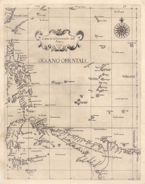
This north-oriented sea chart of the eastern East Indies and the western Pacific is drawn on Mercator's projection, a defining and, for its date, unusual feature of Sir Robert Dudley's Dell'Arcano del Mare, which was the first sea-atlas of any kind to apply the projection uniformly throughout. At a time when most printed charts still used plane constructions that distorted courses over distance, Dudley's consistent use of Mercator's projection, on which a line of constant bearing runs straight, made his charts true instruments for ocean navigation.
In its drawing the chart departs pointedly from the polished, smoothly drawn coastlines of the contemporary Dutch charts, which Dudley knew well and cited constantly; he chose instead the idiom of the Mediterranean portolans and the Portuguese roteiros, in which bays, headlands, and cliffs are strongly exaggerated and the coast rendered in a jagged, deeply indented line that throws the navigator's landmarks into relief. As the first sea-atlas compiled by an Englishman, the work makes this in effect the first chart of these waters drawn by an Englishman, albeit produced entirely in Florence. The second of Dudley's two general charts of Asia, it is the eastern half of a matched pair: drawn to the same scale and the same latitude span (about 27 degrees north to 11 degrees south) as the first general chart, which it adjoins and continues, the western sheet covering the Indian Ocean from Arabia to Sumatra and this one carrying the survey on from the China coast and Celebes across the Philippines and the Moluccas to New Guinea, so that together they form a continuous map of the whole breadth of maritime Asia. From China and the Mare della China at the upper left, an early appearance of that toponym, the chart runs down through the Philippines (I. di Fillipine), with Luzon (I. di Luçon) and Mindanao (Mindanae), to Celebes (I. Celebes), the northern Moluccas off Gilolo with the clove islands of Ternare and Tidore named in their cluster, Amboina, Ceram (I. di Seram), and Banda, and along the lower edge to Timor (I. Tinor) and the lesser Sundas. Eastward the chart runs out across the open ocean, named the Oceano Orientale, past the Ladrones or Marianas (I. di Ladrones ò di Las Velas), with the note Qui Finisce L'Oceano del Mare del Sur marking where the South Sea is reckoned to end, and a mid-ocean island wryly recorded as I. doue passò il Drago Inglese, the island where the English Dragon passed, a memory of Drake's Golden Hind.
The chart's most significant content lies in the lower right, where it sets down recent Dutch discoveries — and the nature of that material is itself revealing. The south coast of New Guinea, with its inland snow-mountain (Mt. di Neue, after the Dutch De Sneeuw Berch), derives from the 1623 voyage of the yachts Pera and Arnhem under Jan Carstensz, the coast charted by the chief pilot Arent Martensz de Leeuw; the snow-capped peaks of the central cordillera, sighted almost on the Equator and long doubted in Europe, were among the most remarkable reports of that survey. The coast is annotated Papuos ò tenuta per Isola Grande e nõ per terra Ferma (Papua, held to be a great island and not mainland), its further shore the Costa Incognita della Noua Guinea, with the legend Terra Scoperta dagl Olandesi recording the Dutch discovery, and the track of the 1615 to 1616 voyage of Jacob Le Maire and Willem Schouten is also marked (I. di Schouten, I. di Mair, I. Scoperta da Iacopo Mair Olandese nel 1616 con la Costa). The depth of this material is significant evidence about Dudley's sources. He engraves the full set of coastal toponyms that originated with the Carstensz expedition — among them R. Van Speult, R. Batavia, the Coen and Nassau rivers, and the bats'-island remembered in the note of giant bats on the companion chart of Celebes — yet the contemporary Dutch printed maps that carried the Pera discoveries into circulation (the wall map of Van Langren of about 1625, the Danckerts and Tavernier world map of 1628, the Hondius world map of 1630) show only the broad outline and a handful of names, not this complete toponymy; nor does any printed Dutch map carry the kind of working pilot's annotation that fills Dudley's seas — the notes of winds, currents, soundings, and climate, and above all the readings of magnetic variation. The variation figures are the most telling of all, for a compass-variation value could only be obtained by direct instrumental observation at sea and existed in no printed source whatever; each reading engraved here is a datum from a VOC pilot's own observation. That Dudley possessed both the full toponymy and these pilot-remarks, found together on no printed source, is clear evidence that he worked not from published maps but from a manuscript chart and first-hand pilot material — and the manner of his copying confirms it. He understood much of his Dutch source, translating its sense into Italian, as where de Leeuw's Drooghte or Drooge Bocht (the dry shoal) becomes Secca Lunga and the bats'-island is rendered by meaning; yet he stumbled over individual unfamiliar words, miscopying Keerweer (the Duyfken's turn-back cape) as ReerWeer and Vleermuijsen as Vluir Moyson, the very kind of slip a non-Dutch hand makes in reading an unfamiliar manuscript, and one no printed map would have produced. Unlike the charts of the little Duyfken, de Leeuw's chart is known from contemporary printed Dutch maps sources to have leaked early, the larger crews of the Pera and Arnhem making secrecy far harder to maintain, and once a single copy was abroad the intelligence could not be recalled.
This eastern chart also lays bare the strategic geography of the VOC's Asian trade. The narrow Strait of Buton, off the southeast of Celebes, reads clearly as the corridor by which the Dutch worked north from Batavia to the clove islands of the northern Moluccas and on to their northern strongholds of Formosa and Japan. The Philippines, by contrast, remained Spanish throughout: the Company planned more than once, notably under Governor-General Van Diemen, to wrest Manila from Spain but never succeeded, and the islands' lack of spices was reason enough not to press the attempt too hard.
This impression is of the second state, from the 1661 edition published by Giuseppe Cocchini, the cartouche bearing the engraved signature Lo2o beneath the title; like the companion first general chart of Asia, it carries in addition a manuscript numeral added in brown ink in an old hand (here 17), an uncommon feature not generally seen on other examples.
Rarity
Charts from the Arcano are rare and much sought after. The atlas was a vast and costly undertaking, running to several large folio volumes, and relatively few copies were ever sold, so that complete examples are exceedingly scarce and come to market only at long intervals: the last two to sell were the Nico and Nanni Israel copy, which realized 731,000 pounds at Christie's London in 2019, and before it the Frank Streeter copy at 824,000 dollars at Christie's New York in 2007. Individual charts accordingly appear only seldom.
Sir Robert Dudley (1573-1649)
Sir Robert Dudley was an English navigator, naval engineer, and cartographer whose great sea-atlas, Dell'Arcano del Mare, stands among the landmarks in the history of maritime cartography. He was born in 1573 at Sheen in Surrey, the son of Robert Dudley, Earl of Leicester, the favourite of Queen Elizabeth I, by Lady Douglas Sheffield. The question of his legitimacy, which turned on whether his parents had been secretly married, shadowed his entire life and was never resolved in his favour by the English courts; it would ultimately drive him from England altogether.
Dudley was educated at Christ Church, Oxford, where he developed the interests in mathematics, navigation, and naval architecture that would occupy him for the rest of his life. Inheriting considerable wealth from his father and his uncle, the Earl of Warwick, he turned in his youth to exploration. In 1594–95 he led an expedition of his own to the West Indies and the coast of Guiana, exploring Trinidad and the Orinoco delta in search of "El Dorado," a venture roughly contemporary with the better-known voyages of Sir Walter Ralegh, with whom his career bears comparison. He afterwards distinguished himself at the 1596 expedition against Cadiz, for which he was knighted.
On his return Dudley pressed his claim to his father's titles. When the suit failed and the matter was ordered suppressed, he left England in 1605, never to return. With him went Elizabeth Southwell, a young woman of the court who travelled disguised as his page; the couple converted to Roman Catholicism and married in Italy, a step that closed off any prospect of return to Protestant England, and much of his English property was forfeited.
Dudley settled in Tuscany, entering the service of the Grand Dukes Ferdinand I and Cosimo II de' Medici, whom he served as naval adviser, engineer, and shipbuilder; he is credited with harbour works at Livorno and the draining of marshland nearby. He styled himself Earl of Warwick and Leicester and Duke of Northumberland, titles he held to be his by right and which the Emperor Ferdinand II is said to have recognized, though they carried no force in England. Over his decades in Italy he gathered the navigational and astronomical learning of a lifetime into the work for which he is remembered.
Dell'Arcano del Mare, "Of the Secret of the Sea," was the culmination of that labour. Dudley had drafted the material over many years and it was at last published at Florence in 1646–47, when its author was in his seventies. It was an achievement of the first importance and a series of firsts. It was the first sea-atlas to cover the whole world rather than European waters alone; the first atlas of any kind to construct all its charts uniformly on Mercator's projection, in the form corrected by the English mathematician Edward Wright; the first to record magnetic declination; the first to set down prevailing winds and currents; and the first to expound the advantages of "Great Circle Sailing," the shortest course between two points on the globe. A defining visual consequence of the Mercator projection is that Dudley's charts dispense with the dense web of radiating rhumb lines found on traditional plane charts, retaining only compass roses, since on this projection a line of constant bearing is already straight and the old loxodromic network would be redundant and misleading.
It was also, in a carefully qualified sense, the first sea-atlas compiled by an Englishman. The earlier Mariner's Mirrour (London, 1588) is sometimes given that distinction, but although English in sponsorship and language — commissioned by Sir Christopher Hatton, translated by Anthony Ashley, and published in the Armada year — it was an adaptation of Waghenaer's Spieghel der Zeevaerdt, its plates engraved largely by Netherlandish hands (Theodore de Bry, Jodocus Hondius, and Johannes Rutlinger, with the Englishman Augustine Ryther), and it was confined to the coasts of Europe. Dudley's atlas, by contrast, was original in content and global in scope, the work of an Englishman throughout in its authorship and compilation, though it too, with a certain symmetry, was engraved abroad.
The charts of the Arcano are as celebrated for their artistry as for their science, and were the work of a single hand, that of the Florentine engraver Antonio Francesco Lucini (b. c. 1605–1610), a pupil of Jacques Callot and friend of Stefano della Bella who had already published views of Florence and scenes of the Turkish wars before entering Dudley's service. Lucini's spare and elegant baroque manner, with its flowing italic lettering "alla cancellaresca," sets the work apart from the dense ornament of the contemporary Dutch charts. In an introductory leaf he left a famous account of the labour involved, claiming to have worked on the plates for twelve years in seclusion in an obscure Tuscan village, consuming some five thousand pounds of copper.
In their cartographic style the charts are equally distinctive, and the distinction is deliberate. Dudley knew the polished Dutch sea-charts of his day intimately and cited them throughout, yet he did not imitate their smooth, "modern," filled-in coastlines. He drew instead in the older idiom of the Mediterranean portolans and the Portuguese roteiros, in which bays, headlands, cliffs, and river-mouths are strongly exaggerated and the coast is rendered as a jagged, deeply indented line. The effect is not a failure of accuracy but a different conception of what a chart is for: by enlarging the coastal features a pilot would look for from seaward, the drawing throws the navigator's landmarks into relief, in the manner of the manuscript sea-charts of the Mediterranean and Iberian traditions rather than the engraved atlases of Amsterdam. Behind the charts, too, lay sources of unusual quality. The atlas's claim to be among the first to record magnetic declination, and the prevailing winds and currents, was no mere editorial flourish: such data could not be had from any printed map, for a compass-variation reading or a current observation existed only where a navigator had measured it at sea. For distant waters Dudley must therefore have drawn on manuscript charts and the first-hand working papers of pilots — in the case of the East Indies, demonstrably on unpublished Dutch material, including a leaked manuscript chart of the 1623 Carstensz voyage to New Guinea and northern Australia, whose detailed coastal toponymy and pilot's annotations he reproduces though they appear on no printed Dutch map. The Arcano is thus a far rarer kind of compilation than its Italian imprint suggests: a work of original science resting on the confidential navigational intelligence of the age. A further trace of the period's unsettled conventions is the prime meridian: like other makers before the general adoption of Greenwich, Dudley reckoned longitude from an Atlantic island, here Pico in the Azores, where earlier traditions had variously used the Canaries or Fortunate Isles, the Peak of Tenerife, or Ferro.
Dudley died near Florence in 1649. The first edition of 1646–47 had appeared in three folio volumes of differing formats, so large that some charts had to be folded several times to fit; this shortcoming was remedied in the second edition, issued at Florence in 1661 by Giuseppe Cocchini, which gathered the work into two volumes of uniform atlas size, Book VI being the sea-atlas proper, with some 130 charts. In this second edition the charts appear in a second state, distinguished by a small engraved signature, "Lº.2º.", added to the title cartouches; first-state impressions, from the 1646–47 edition, lack this addition.
Related Categories
Related Items