Leen Helmink Antique Maps
Eighteen costume plates of the Indian Ocean world and Africa

Stock number: 19837
Image GalleryCartographer(s)
Carel Allard (biography)
Title
Indian Ocean City Views
First Published
Amsterdam, 1695
Size
22.0 x 28.0 cms
Technique
Condition
excellent
Price
$ 9,500.00
(Convert price to other currencies)
Description
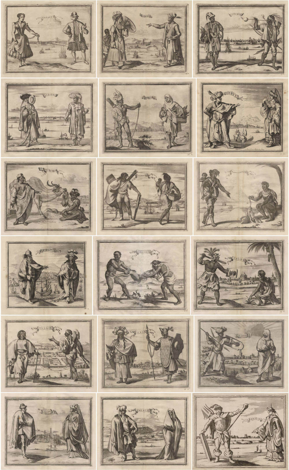
Thematic set of seventeen exceptionally important costume views, covering the Indian Ocean world and Africa, from Carel Allard's unobtainable Orbis habitabilis Oppida et Vestitus (The Towns and Costumes of the Inhabited World), the rarest of all town books. Plus one additional plate from a separate example (18 prints in total).
Eighteen copper engravings by Aldert Meijer, after designs by Johannes de Ram (1648–93). Each plate shows a male and female figure in local costume, set against a reduced city view, with the place name on a banner. Each plate ca. 22 × 27.5 cm (platemark), on sheets ca. 36.5 × 39.5 cm. Imprint: ex formis Carol. Allard cum Privil. or Cum Privilegio.
Pioneered by Allard, these are the first costume plates ever published as integral companions to a town book, rather than as incidental staffage, and they occupy a unique position in the history of European ethnographic illustration. As Old Master prints, their balanced compositions and graphic quality have made them among the most sought after Dutch topographic engravings of the period.
Description
A remarkable group of seventeen costume plates from Carel Allard's Orbis Habitabilis Oppida et Vestitus, the rarest of all European town-books and the first to systematically pair topographical views with corresponding costume plates, supplemented by one additional plate from a separate example (18 plates in total). Each engraving presents a man and a woman in local dress, set against a reduced view of their city or territory in the background, with the place name inscribed on a floating banner. The seventeen plates of the core set depict cities and peoples across Africa and the Indian Ocean world: the vast maritime network connecting the Barbary coast, West and Central Africa, the East African littoral, the Cape, the Arabian peninsula, Persia, India, Ceylon, and the East Indies, as seen through Dutch eyes at the height of VOC commercial expansion. The supplementary plate depicts Mongolia, extending the geographical range into Central Asia.
Allard's town-book, containing 100 numbered plates in all, was published in Amsterdam around 1695 with a foreword by the physician and antiquary Ludolph Smids (1649–1720), who invited the reader to "travel the world on foot, on horseback, by coach, or by sea, discoursing with remote peoples, admiring their costumes and ornaments, their churches and buildings" — all without leaving the comfort of his study. The costume plates were executed by Aldert Meijer (active 1686–88), largely after designs by the Amsterdam engraver Johannes de Ram (1648–93), whose pioneering collection of 48 plates (Colas no. 2480) first depicted costumes of the entire known world by pairing male and female figures against topographical backgrounds. De Ram was a somewhat more original artist and publisher than Allard; his collection, which must have appeared before his death in 1693, seems to be the earliest in this form. The background city views draw on multiple Dutch and other printed sources from the 1660s and 1670s, including travel accounts and geographical compilations published in Amsterdam by Jacob van Meurs and others.
What distinguishes Allard's work from its predecessors in the tradition of Braun & Hogenberg's Civitates Orbis Terrarum (1572–1617) is its systematic ethnographic ambition. Where earlier town-books placed costumed staffage figures in the foreground of city views as decorative elements, Allard elevated costume illustration to equal status, devoting separate plates to the dress and appearance of each people. As R.A. Skelton observed in his authoritative introduction to the 1966 facsimile edition, Allard was "so far as we know, the first editor of a town-book to couple topographical plates and corresponding costume-plates." The plates are executed in a free style with noticeable bravura, combining line-engraving and etching to achieve a vivid, expressive quality that sets them apart from the more formulaic costume illustrations of the period. The result is a uniquely lively visual record of how late seventeenth-century Amsterdam perceived the diverse cultures of the wider world.
The present core set of seventeen plates forms a coherent visual survey of the non-European world as Dutch merchants, navigators, and colonial administrators encountered it. The geographical sweep is extraordinary: from the Barbary states of North Africa (Tunis, Algiers, Marrakech) through the kingdoms of West and Central Africa (Benin, Loango, Congo, the interior), along the East African coast (Luanda, Mozambique, the Cape of Good Hope) and Madagascar (Fort Dauphin), across the Indian Ocean to the great trading emporia of western India (Surat, Goa, Cochin), the strategic island fortress of Hormuz in the Persian Gulf, the VOC stronghold of Batticaloa on Ceylon, and finally to Batavia, the capital of the Dutch East Indies. Together these plates trace the principal sea routes and commercial nodes of the Indian Ocean trading system in which the VOC was the dominant European power by the late seventeenth century.
The complete Orbis Habitabilis is of the utmost rarity. Only three copies are recorded in institutional holdings (Bayerische Staatsbibliothek, Munich; British Library, London; Library of Congress, Washington). The last copy to appear at auction was the incomplete coloured example from the collection of John Landwehr, sold in Hamburg in 2010 for €57,000 — notably lacking the highly valued costume plate of New Amsterdam (New York). Even individual plates from the work appear infrequently on the market: when that single New York costume plate was offered separately at auction (Swaen, 2010), it realised USD 12,320. The present uniform set of seventeen plates, preserving the coherence and context of the African and Indian Ocean sections, together with the supplementary Mongol plate, represents an exceptional opportunity to acquire a substantial portion of this celebrated work.
References: Phillips/LeGear 5385; Skelton, R.A., Introduction to facsimile edition (Amsterdam, Theatrum Orbis Terrarum, 1966); Koeman, C., Collections of Maps and Atlases in the Netherlands (Leiden, 1961); Hollstein I, 24, 53. Not in Lipperheide; not in Colas.
List of Plates
Plates 1–17: uniform set from the same binding. Plate 18: from a separate example.
Asia and the Indian Ocean
1. Batavia
Costume plate depicting inhabitants of Batavia (present-day Jakarta), capital of the Dutch East Indies and seat of the Governor-General of the VOC. The fortified city, founded in 1619 on the ruins of the Javanese port of Jayakarta, served as the nerve centre of Dutch commercial operations throughout maritime Asia. The background view shows the city's characteristic canals and fortifications. The figures display the hybrid dress culture of the colonial port, reflecting the diverse population of Dutch, Javanese, Chinese, and other communities that made Batavia one of the most cosmopolitan cities in the seventeenth-century world.
2. Goa
Costume plate of inhabitants of Goa, capital of Portuguese India and the Estado da Índia since 1510. Known as the "Rome of the East" for its magnificent churches, Goa was the most important European settlement in Asia before the rise of Dutch Batavia. By the time of Allard's publication, Portuguese power in the Indian Ocean was in decline, but Goa remained a major entrepôt and the seat of the Portuguese Viceroy. The figures wear the elaborate dress characteristic of the Indo-Portuguese elite.
3. Coichin (Cochin)
Costume plate of inhabitants of Cochin (present-day Kochi) on the Malabar Coast of southwestern India, one of the oldest European colonial settlements in the East. Originally a Portuguese stronghold established by Afonso de Albuquerque in 1503, Cochin was captured by the VOC in 1663 and became one of the principal Dutch factories on the Indian coast. The city was the centre of the immensely lucrative pepper and spice trade. The figures represent the costume of the local Malabar population.
4. Suratte (Surat)
Costume plate of inhabitants of Surat in Gujarat, the principal commercial port of the Mughal Empire and the gateway to the riches of Hindustan. Both the Dutch and English East India Companies maintained important factories at Surat, which also served as the main port for the annual Hajj pilgrimage fleet to Mecca and Jeddah. The city was among the wealthiest in the world during the seventeenth century, its markets handling vast quantities of textiles, indigo, spices, and precious stones. The figures wear the richly draped costume of the Mughal trading classes.
5. Mate Calo (Batticaloa Fort, Ceylon)
Costume plate of inhabitants of Matecalo, the Dutch name for Batticaloa on the east coast of Ceylon (present-day Sri Lanka). The site is associated with the dramatic events of 1602, when VOC vice-admiral Sebald de Weert and his men were killed by order of the local king after a diplomatic incident — one of the earliest violent confrontations between the Dutch and a South Asian ruler. The VOC subsequently established a fort at Batticaloa which became a strategic base for controlling the eastern coast of Ceylon and its cinnamon trade. The figures display Sinhalese costume.
6. Ormus (Hormuz)
Costume plate of inhabitants of Hormuz, the island fortress at the mouth of the Persian Gulf that controlled all maritime trade between the Indian Ocean and Persia, Mesopotamia, and the Levant. Under Portuguese control from 1515 to 1622, when it was captured by a combined Anglo-Persian force, Hormuz was one of the wealthiest and most strategically important cities in the early modern world. The background view shows the fortified island city with European vessels in the harbour. The costumed figures wear elaborate Persian-influenced dress with turbans. Plate numbered "5 a", with imprint ex formis Carol. Allard cum Privil.
East Africa and Indian Ocean Staging Posts
7. Het Fort Dauphin (Madagascar)
Costume plate of inhabitants of Fort Dauphin (present-day Tôlanaro) on the southeastern coast of Madagascar, established as a French colonial outpost by the Société Française de l'Orient in 1643. Named in honour of the future Louis XIV, the settlement was intended as a base for French operations in the Indian Ocean but was plagued by conflict with the local Antanosy people. It was abandoned in 1674 after a massacre of the French garrison. The plate reflects the considerable European interest in Madagascar as a potential waystation on the route to the East Indies.
8. Mozambique
Costume plate of inhabitants of Mozambique Island, the fortified Portuguese trading post on the East African coast that served as a crucial staging post on the Carreira da Índia, the sea route between Lisbon and Goa. The island's Fort São Sebastião, built in 1558, was the largest Portuguese fortification in East Africa. Mozambique was a key node in the Indian Ocean trading system, handling gold and ivory from the interior and serving as a provisioning point for ships rounding the Cape. The figures display the local costume of the island's cosmopolitan population.
9. C. D. Bona Esperance (Cape of Good Hope)
Costume plate of inhabitants at the Cape of Good Hope, where the VOC established a refreshment station under Jan van Riebeeck in 1652, which grew into a permanent settlement. The Cape served as the critical halfway point on the long voyage between the Netherlands and the East Indies, where VOC fleets could resupply with fresh water, provisions, and livestock. The figures likely depict indigenous Khoikhoi people, whose interactions with the Dutch settlers defined the early colonial history of southern Africa.
10. Loanda S. Paulo (Luanda, Angola)
Costume plate of inhabitants of São Paulo de Luanda, founded by the Portuguese in 1575 as the capital of their colony of Angola. Luanda was one of the largest European-controlled ports in sub-Saharan Africa during the seventeenth century. The Dutch West India Company (WIC) briefly captured and held the city from 1641 to 1648, and the plate may reflect Dutch intelligence gathered during this occupation. The figures display the costume of the local Angolan population.
West and Central Africa
11. Binnelandse Africanen (Interior Africans)
Costume plate depicting peoples of the African interior, a subject of intense European curiosity in the seventeenth century. Unlike the coastal subjects in this set, which were documented by direct observation from European merchants and sailors, knowledge of the African interior was largely based on second-hand reports from African intermediaries and Arab traders. This plate represents the ethnographic imagination of late seventeenth-century Amsterdam, filtered through the geographical compilations published by Jacob van Meurs and other Amsterdam printers.
12. Congo
Costume plate of inhabitants of the Kingdom of Kongo, one of the most powerful states in Central Africa and among the first African kingdoms to establish diplomatic relations with a European power when Portuguese missionaries arrived in the 1480s. The Kongolese court adopted Christianity and maintained embassies in Lisbon and Rome. The extensive seventeenth-century Dutch literature on the kingdom provided rich visual and textual sources for Meijer's depiction of Kongolese costume and customs.
13. Louango (Loango)
Costume plate of inhabitants of the Kingdom of Loango, situated on the coast of present-day Republic of the Congo, north of the mouth of the Congo River. Loango was a major trading state with extensive commercial networks connecting the coast to the interior. Dutch traders established a factory at Loango in the 1640s, and the kingdom became an important source of ivory, copper, and redwood for the Amsterdam market. The figures display the distinctive dress and adornment of the Loango court.
14. Benin
Costume plate of inhabitants of the Kingdom of Benin, in present-day southern Nigeria, renowned throughout Europe for its sophisticated court culture and the celebrated Benin bronzes. Seventeenth-century Dutch accounts provide some of the earliest and most detailed European descriptions of Benin City, including its broad avenues, royal palace, and elaborate ritual life. Dutch traders maintained commercial relations with Benin from the early seventeenth century, dealing principally in pepper, ivory, and textiles. The figures represent the elaborate ceremonial dress of the Benin court.
North Africa
15. Marocco (Marrakech)
Costume plate of inhabitants of Morocco (i.e. Marrakech), the imperial capital of the Saadian and Alaouite dynasties. The figures are dressed in characteristic Moorish costume, richly draped and turbaned. The background view shows the city with its distinctive walls and minarets.
16. Algiers
Costume plate of inhabitants of Algiers, the principal city of the Ottoman Regency of Algiers and the most formidable of the Barbary corsair states. Algiers was a constant concern for European maritime powers throughout the seventeenth century; the Dutch Republic maintained diplomatic relations with the Regency, and numerous Dutch captives were held in the city's slave markets. The background view shows the city's famous terraced hillside rising from its fortified harbour.
17. Thunis (Tunis)
Costume plate of inhabitants of Tunis, capital of the Ottoman Regency of Tunis and one of the great cities of the Islamic Mediterranean. Like Algiers, Tunis was a centre of Barbary corsair activity that directly affected Dutch and other European shipping. The Dutch Republic concluded several treaties with the Regency of Tunis during the seventeenth century to protect its commercial interests in the Mediterranean. The background view shows the city with its harbour and fortifications.
Supplementary Plate
Added: one plate from a different example of the same work, bringing the total to 18 prints.
18. Mongul (Mongolia)
Costume plate of Mongol inhabitants, plate 34 in the original sequence, signed A. Meijer fecit and bearing the Cum Privilegio imprint. The male figure is depicted as a warrior in a fur tunic and helmet, armed with a long sword and a large rectangular shield, his posture dramatic and assertive. The female figure wears layered robes and a pointed headdress. The background view shows a walled Mongol or Chinese city on a riverbank, with a junk under sail. The Mongol Empire and its successor khanates were a subject of enduring fascination in seventeenth-century Europe, fuelled by accounts of overland embassies and the diplomatic contacts maintained by the VOC and the Russian court. De Ram's original design for this plate draws on the extensive Dutch literature on Central and East Asian peoples published in Amsterdam during the 1660s and 1670s.
Rarity
Of utmost rarity, considered unobtainable and lacking in all collections.
Significance
These plates constitute one of the earliest systematic European attempts to document the dress, adornment and appearance of peoples across Africa and Asia, each set against a recognisable view of their city or territory, and they remain among the most visually compelling ethnographic records of the late seventeenth century Indian Ocean world.
If the maps and charts of the period are the seventeenth century equivalent of Google Earth, these costume plates are its Google Street View, placing the viewer on the ground among the people themselves.
Especially well suited for exhibition display, thematic presentations and education around early encounters.
Condition description
Sharp, well-balanced impressions from the copper plates, with generous margins throughout. No restorations or imperfections.
The supplementary plate of the Mongols with short margins and pasted onto another sheet.
Carel Allard (1648-1709)
CAREL ALLARD (1648 - 1709) was the elder son of Hugo or Huych Allard, an Amsterdam cartographer and mapseller with a shop ‘op den Dam'. From about 1645 Hugo was actively engaged in the production of printed sheet-maps, although he never published an atlas (the British Museum catalogues an atlas of 29 maps by him (Maps 39. f. 3), but examination of its history proves this collection to be an 'atlas factice'). Some years before his death in 1691, the business seems to have been taken over, at the same address, by his son and partner Carel, who on in October 1683 obtained a 15-years' copyright privilege from the States of Holland and West Friesland for unspecified 'maps, towns, portraits, and prints of all kinds' already published by him or to be published in the future. The miscellaneous character of Carel Allard's output as a 'kunstvercooper', implied by the terms of the privilege, is illustrated by inventories of his plates drawn up towards the end of his career, in 1706 and 1708. The maps which formed a substantial part of it were thought well of by J. G. Gregorii (1713), who considered Allard 'a skilful artist', but apparently more for the elegance of their design and illumination than for their scientific quality. The more discriminating Hauber (1724) and Hübner (1726) give no more than a passing mention to Allard and his maps.
After the expiration of his general privilege in 1698, Allard petitioned for its renewal in wider terms (the precise character of which is not clear), submitting the 'specification' of the maps for his Atlas Minor as a sample of his cartographic work. His application, twice made in 1699, was referred to members of the booksellers' guild as assessors, and their reports suggest that Allard did not enjoy particularly good repute in the print-trade. Examining the 'so-called (pretense) Atlas Minor’, as they contemptuously called it, they found that most of the maps to be included in it 'were made and published long ago, under privilege, by other print- and mapsellers’, and they noted that Allard had been in trouble both at Amsterdam and at Frankfurt (presumably at the book-fair) for distributing 'lewd and scurrilous drawings and prints'. Their recommendation was that the old privilege be renewed, but without the additional protection solicited by the applicant.
Before this, Allard seems to have embarked on the production of atlases and town-books. Their chronology is doubtful, all being undated. His Atlas Minor is usually ascribed by bibliographers, on internal evidence, to the year 1696; although the documents relating to the renewal of his privilege suggest that in 1699 it was still unpublished, there may have been an earlier edition. In 1707 two versions of Allard's Atlas Minor were advertised, the larger in two volumes with 260 plates, the smaller with 150 plates, besides his Atlas Major in three volumes with 521 plates. The contents of the Atlas Major exemplify his practice in atlas-construction, as observed by the assessors in 1699. Few of its maps were compiled or engraved by Allard or have his imprint; the majority are impressions of maps published by Visscher, Jansson and his successors, and De Wit. with some by Blaeu, Danckerts, Mortier, Schenk, Jaillot and others. Since the make-up of such an atlas depended on the mapseller's retail stock at the time of sale, it may be considered an 'atlas factice' notwithstanding its printed titlepages and tables of contents. A copy of the Atlas Major described by Tiele contained a map by Schenk dated 1705, so that it must have been on sale between that year and 1707. Allard's Magnum theatrum belli, of 57 maps, was constructed in the same way, drawing heavily on the production of Visscher and other publishers.
His book of towns and costumes, the Orbis habitabilis oppida et vestitus, is more homogeneous in character and personal in style. Although (as will be seen) its plates were largely — if not entirely - copied from earlier published work, there is little reason to doubt that its engravers worked under Allard's direction, if not in his shop, and that he imposed on the collection the unity and individuality which distinguish it. Pieter Schenk paid it the compliment of extensive plagiarism in his Hecatompolis sive ... oppida nobiliora centum (1702), copying from Allard's book no fewer than 47 views of towns and echoing its title in his own.
The publication date of the Orbis habitabilis oppida et vestitus is uncertain. We know only that (since 73 of its plates, including the engraved titlepage, bear the privilege statement) it must have come out between 1683, when Allard received his first privilege, and 1702, when Schenk produced his copies. Mrs LeGear (1958, describing Phillips 5385) supposes publication to have been before 1698, when the original privilege expired; but, as we have seen, the privilege appears to have been renewed in 1699, and later works by Allard, e.g. the Atlas Major, still carry the privilege statement. Hiler (1939), on the other hand, held the work to have been 'issued after 1700 and, it may be, as late as 1710', but without giving any reason. Of the two engravers who sign plates, Thomas Doesburgh is known to have been working 1683 - 1714, and Aldert Meijer 1686 - 88 (Waller 1938). The printed sources used for the views, such as the works by Olfert Dapper published in the 1670s, were mostly somewhat earlier. The likeliest date for the publication of Allard's town-book seems to be about 1695.
The typographic titlepage of the Orbis habitabilis oppida et vestitus names Carel Allard as compiler and editor, as well as publisher, of the collection; and his privilege is cited in the imprint. In the foreword in Latin and Dutch, Ludolph Smids (1649 - 1720), a Groningen physician and antiquary who had settled at Amsterdam in 1685, makes the customary claim that anyone using such a collection could, without leaving the comfort of his own study, 'travel the world on foot, on horseback, by coach, or by sea, discoursing with remote peoples, admiring their costumes and ornaments, their churches and buildings'. This is the keynote of the collection, already struck in its title. Curiously, Smids also signs the list of plates in Schenk's Hecatompolis (1702). In the long series of town-books, the illustration of topography and of social life had gone hand-in-hand ever since Georg Braun, the editor of the prototype, the Civitates orbis terrarum, had written in his foreword of 1572: 'We have introduced into the views of towns representations of the costumes of various nations'. This 'ethnographic' purpose, no doubt allied to a sense of pictorial effect, explains the figures or groups in national dress placed in the foreground of views and plans by Joris Hoefnagel and the other artists who, working in his convention, contributed to the Civitates and subsequent city-atlases. (Here, and in the similar vignettes engraved in the cartouches or margins of maps from Amsterdam workshops, we may suspect the influence of Dutch 'genre' painting). Carel Allard however was, so far as we know, the first editor of a town-book to couple topographical plates and corresponding costume-plates. In his collection, twenty-three of the subjects (making 46 plates) are represented by such pairs, the costumed figures in the second plate being backed, in all cases but three, by a reduced version of the same view as that presented, on a larger scale, in the first plate. Of the remaining 54 plates, 36 are views of towns, and 18 are costume pictures or characteristic 'genre' groups.
The 100 numbered plates are executed in a free style with noticeable bravura, using line-engraving and etching in combination. Of the costume-plates 36 are signed by Meijer, and the other five are almost certainly by him. Twenty views have Doesburgh's signature, and the remaining 39 are engraved in a style and with decoration indistinguishable from those of his signed plates.
For over two-thirds of the views, printed sources have been found without much difficulty, and it is probable that all were copied by Doesburgh from earlier engravings. Fourteen European views, together with one in Asia and one in America, are derived either from the collection Icones praecipuarum urbium totius Europae, published by Clement de Jonge in 1675, or from the closely similar (though more numerous) views in Frederik de Wit's Theatrum praecipuarum totius Europae urbium, undated but apparently of about 1690. For Asia, Africa and America the engraver of Allard's views drew heavily on the illustrated historical-geographical works of Olfert Dapper, published in the years 1670 - 73; these books supplied the models for four views in Persia, eight in Africa, and eleven in America. In copying 'Morocco' (Marrakech), Doesburgh mistakenly reversed the design, and he was followed in the error by Schenk's engraver. London is one of the three towns of which the view forming the background to the costume-plate differs from the larger view in the preceding plate; although both seem to be based on the same original, the larger view (like De Wit's) adds Wren's rebuilt, or projected, St Paul's and the Monument to the Great Fire.
The greater number of the costume-plates by Meijer are copies from a single source. This was a collection of 48 plates without title or date (Colas, no. 2480) by the Amsterdam engraver Johannes de Ram (1648 – 93), illustrating costumes of the world, with male and female figures paired on each plate against a topographical background. From this Meijer took no fewer than 34 of his designs. De Ram was a somewhat more original artist and publisher than Allard; his collection, which must have appeared before his death in 1693, seems to be the earliest in this form, depicting costumes of the whole world by pairs of figures; and it provided the model not only for Allard's plates but also for those etched by Caspar Luyken and published by Christoph Weigel at Nuremberg in 1703 under the title Neu-eröffnete Welt-Gallerie (Colas, no. 2189), with text by Abraham a Santa Clara.
It appears that after 1700 Allard's business did not prosper. His atlases seem to have had only limited success, no doubt (as suggested by Koeman 1961) because seventeenth-century cartography could no longer compete with the newer production of French workshops, which 'answered more effectively the demands for accuracy and modernity'; moreover, as recorded by Hübner (1726), German publishers were able to undercut the prices of the Dutch in the map-market. The evidence for the decline in Allard's affairs is to be found in documents printed by Kleerkooper and van Stockum (1914 - 16) and in an Amsterdam auction-catalogue analysed by Koeman (1961).
On 8 March 1706, Carel Allard conveyed to his sons Abraham and Hugo 'shop-goods', i.e. stock in trade, of a value equivalent to the patrimony to which they were entitled under a deed executed by him on 7 July 1683, two days before his second marriage, when they were still under age. Among the engraved plates in the stock thus transferred are listed some which can probably be identified with those of the Orbis habitabilis oppida et vestitus, namely, '56 steden', '40 dragten', and 'I titel tot het Stedeboek van 100'. On 7 August 1708 a quantity of maps and atlases by Amsterdam publishers (estimated by Koeman at no fewer than 10.000 sheets) were sold by auction in Jan Needer's rooms; among them are catalogued the 'Stedeboek van 100 steden en Dragten, in folio, C. Allard', besides his Atlas Major, Atlas Minor and 'Tooneel des Oorlogs'. Koeman suggests, with some reason, 'that we have to do here with the sale of the surplus stock of the publisher Carel Allard'. By this time Allard was in financial difficulties, of which Needer's sale was perhaps a consequence; for only a month later, on 7 September 1708, an inventory of the copper plates held by 'the administrator of the bankrupt shop (curateur over den insolventen boedel) of Carel Allard' was drawn up at the instance of the administrator himself and of Abraham Allard, who presumably wished to safeguard his own property from his father's creditors.
In 1709 Carel Allard died. Although Abraham remained in business as a map-engraver and publisher until his own death in 1725, many of his father's plates came into the possession of the Leiden publisher Pieter van der Aa. Those of the agreeable, if not very original, book of towns and costumes seem to have made in 1710, one more separate appearance over Van der Aa's imprint, if we suppose that they formed the nucleus of a collection recorded by bibliographers (but not seen by the present author) under the title Habillemens de plusieurs Nations, representez au naturel, en cent trente-sept belles figures (Colas, no. 1367). The plates were used for the last time, with plate-numbers deleted, in the vast corpus of prints published by Van der Aa in 1729 as La Galerie Agréable du Monde.
(R.A. Skelton)
Related Categories
Antique maps of the East India Company
Old Master Prints
Antique maps of Australia
Antique maps of China
Antique maps of the Philippines
Antique maps of Southeast Asia
Antique maps of India and Ceylon
Antique maps of Korea
Antique maps of the Middle East
Antique maps of Asia
Antique maps of Africa
Old books, maps and prints by Carel Allard


