Leen Helmink Antique Maps
Antique map of Russia by Ortelius

Stock number: 18761
Zoom ImageCartographer(s)
Abraham Ortelius (biography)
Title
Russiae, Moscoviae et Tartariae descriptio
First Published
Antwerp, 1570
This Edition
1571 Dutch
Size
35.4 x 44.2 cms
Technique
Condition
excellent
Price
$ 1,900.00
(Convert price to other currencies)
Description
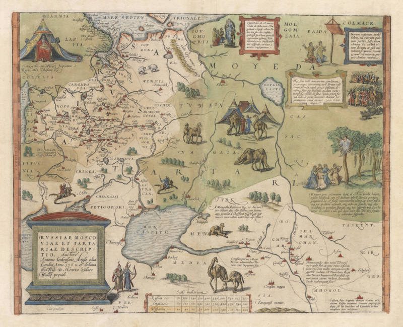
Antony Jenkins' spectacular map of Russia, issued by Ortelius.
"A map of 'Russia, Muscovy, and Tartary' by Anthony Jenkinson of the English Muscovy Company was engraved by Frans Hogenberg for Ortelius' 'Theatrum' in 1570 - with vignettes based on Marco Polo. Originally 'published in London in 1562', it stems from Jenkinson's journey to Bukhara in 1557-59. He went to Russia three more times, but into Asia (as far as Persia) only once more."
(Tooley & Bricker).
"Interesting folklore on eating, religion, and 'burial' of the dead in trees in texts and pictures."
(van den Broecke).
"This is the earliest surviving work based on the lost map of Anthony Jenkinson. An agent of the Company of Merchant Adventurers (Muscovy company), Jenkinson traveled in Russia from 1557 to 1560. He took regular notes during his travels; thus, much of this map is based on first hand observation. Jenkinson traveled from Archangel to Moscow (where he met Czar Ivan the Terrible) then via the Volga and Caspian Sea to Bukhara in present-day Uzbekistan, one of the cities on the ancient Oriental Silk Route. Jenkinson is believed to be the first European to cross Russia from north to south and the first Englishman to penetrate so far into Central Asia beyond the Caucasus in this period. On his return to England in 1560 he compiled detailed accounts of his expedition and also prepared a large-scale map on 4 sheets which was first published by Nicholas Reynolds in London in 1562. JenkinsonÔÇÖs original map was believed lost until a now seemingly unique copy came into the hands of the Library of the Polish University of Wroclaw in 1988. OrteliusÔÇÖ map replicates much of the detail and decoration found on the original Jenkinson map, with vignettes of camels, caravaneseri, the curious custom of burying the dead in the branches of trees, as well as amusing annotations on Russian and Central Asian folklore, religion, and eating habits. A vignette of Ivan the Terrible appears top left."
(James Hess).
"Title: RVSSIAE, MOSCO:/VIAE ET TARTA:/RIAE DESCRIP:/TIO Auctore/Antonio Ienkensono Anglo, edita/Londini Anno 1562 & dedicata/illustriss. D. Henrico Sijdneo/Walliei presidi. Cum priuilegio.
<= Image of Russia, Moscovia and Tartaria by Antonius Jenkins the Englishman, published in London in 1562, and dedicated to the most illustrious Lord Henricus Sidneus, leader of the Wallei. With privilege>
Zlata Baba, id est aurea vetula ab Obdorianis, & lougorianis religiose colitur. Idolum hoc sacerdos consultit, quid ipsis faciendum, quoue sit migrandum,imsumq. (dictu mirum) certa consulentib. dat responsa,certique euentus consequuntur
<= Zlata Baba, that is golden granny, is devotedly worshipped by the Odorians and Iougorians. The priest consults this Idol about what to do and where to go and (it is a wonder to relate) she gives clear answers to those consulting her, leading to certain outcomes>.
Horum regionum incole Solem,vel rubrum pannum pertica suspensum adorant. In castris vitam ducunt; ac oim animatium, serpentiu, vermiunque carne vescentur.ac proprio idiomate vtuntur
<= The inhabitants of this region adore the Sun or a red cloth hanging from a pole. They live their lives in fortresses and eat the meat of animals, snakes and worms, and they have their own language>.
Hec saxa hoim iumentorum camelorum pecorumque,ceterarumq. reru formas referentia,Horda populi gregis pascentis,armentaq. fuit; Que stupenda quadam metamorphosi,repente in saxa riguit,priori forma nulla in parte diminuta. Euenit hoc prodigium annis circiter 300. retro elapsis
<= This rock which has the shapes of people, cattle, camels and other animals and things was once a group of shepherds and their flocks who suddenly petrified in an amazing metamorphosis, without changing their previous appearance. This miracle took place 300 years ago>.
A mangusla Shayfuram usq. 20 dierum iter habent,sine ullis sedibus,cum summa aque penuria. A Shayura usq. Bogar,var itineris interuallum latrocinijs infestum
<= from Manguslato Shaijsure is a journey of 20 days without encampments and with an exceeding shortage of water. From Shaijsure to Bogar is a similar distance, infested by robbers>.
Corasan parva, a Rege Persico adiuvantibus Tartaris 1558 expugnata fuit
<= The small city of Corasan has been captured by the King of Persia with the assistance of the Tartars in 1558>.
Kirgessi gens cateruatim degit, id est in hordis.habetq. ritum huiusmodi.cum re divinam ipsoru sacerdos peragit,sanguinem,lac & fimu iumentorum accipit,ac terre miscet, inq. vas quoddam infundit,eoq. arborem scandit,atq. concione habita,in populum spargit,atq. hec aspersio pro Deo habetur & colitur. Cum quis diem inter illos obit,loco sepulture arboribus suspendit
<= The Kirgessen people live in troups or hordes. They have the following custom: when a priest performs a religious ceremony, he obtains blood, milk and dung of beasts of burden, and mixes it with earth. He pours this in a specific vessel and climbs a tree with it, and when there is a gathering, he spinkles it over the people, and this sprinkling is considered to be divine, and is worshipped. When someone of them dies, that person is hung up in a tree by way of burial>.
Shamarcandia olim totius Tartarie metropolis fuit,at nunc ruinis deformis iacet,una cum multis antiquitatis vestigijs. Hic conditus est Tamerlanes ille, qui olim Turcaru Imperatore Byasite captum aureis catenis vinctum,circumtulit. Incole mahumetani sunt
<=Shamarcandia was once the capital of all of Tartary, but now it has decayed to ruins, with many remnants from antiquity. Here Tamerlan lies buried, once the captor of the ruler of the Turks, Bayasid. He took him as a prisoner and abducted him, bound in gold chains. The inhabitants are Muslims>.
Cascara,hinc triginta dierum itinere orientem versus incipiunt termini imperij Cathaye Ab his limitibus ad Cambalu trium mensium interiacet.
<= Cascara. When travelling from here for thirty days, one reaches the borders of the Empire of Cathay <= China>. The distance between these borders and Cambala is a journey of three months>. "
(Van den Broecke).
Abraham Ortelius (1527-1598)
Abraham Ortelius is the most famous and most collected of all early cartographers. In 1570 he published the first comprehensive collection of maps of all parts of the world, the Theatrum Orbis Terrarum ("Theatre of the World"), the first modern atlas as we know it.
"Abraham Ortel, better known as Ortelius, was born in Antwerp and after studying Greek, Latin and mathematics set up business there with his sister, as a book dealer and ‘painter of maps'. Traveling widely, especially to the great book fairs, his business prospered and he established contacts with the literati in many lands. On one such visit to England, possibly seeking temporary refuge from religious persecution, he met William Camden whom he is said to have encouraged in the production of the Britannia.
A turning point in his career was reached in 1564 with the publication of a World Map in eight sheets of which only one copy is known: other individual maps followed and then – at the suggestion of a friend - he gathered together a collection of maps from contacts among European cartographers and had them engraved in uniform size and issued in 1570 as the Theatrum Orbis Terrarum (Atlas of the Whole World). Although Lafreri and others in Italy had published collections of ‘modern' maps in book form in earlier years, the Theatrum was the first uniformly sized, systematic collection of maps and hence can be called the first atlas, although that term itself was not used until twenty years later by Mercator.
The Theatrum, with most of its maps elegantly engraved by Frans Hogenberg, was an instant success and appeared in numerous editions in different languages including addenda issued from time to time incorporating the latest contemporary knowledge and discoveries. The final edition appeared in 1612. Unlike many of his contemporaries Ortelius noted his sources of information and in the first edition acknowledgement was made to eighty-seven different cartographers.
Apart from the modern maps in his major atlas, Ortelius himself compiled a series of historical maps known as the Parergon Theatri which appeared from 1579 onwards, sometimes as a separate publication and sometimes incorporated in the Theatrum."
(Moreland and Bannister)
"The maker of the ‘first atlas', the Theatrum Orbis Terrarum (1570), started his career as a colorist of maps. Later, he became a seller of books, prints and maps. His scientific and collecting interests developed in harmony with those of a merchant. He was first and foremost a historian. Geography for him was the ‘eye of history', which may explain why, in addition to coins and historical objects, he also collected maps. On the basis of his extensive travels through Europe and with the help of his international circle of friends, Ortelius was able to build a collection of the most up-to-date maps available.
The unique position held by Ortelius's Theatrum in the history of cartography is to be attributed primarily to its qualification as ‘the world's first regularly produced atlas.' Its great commercial success enabled it to make a great contribution to ‘geographical culture' throughout Europe at the end of the sixteenth century. Shape and contents set the standard for later atlases, when the centre of the map trade moved from Antwerp to Amsterdam. The characteristic feature of the Theatrum is that it consists of two elements, text and maps. Another important aspect is that it was the first undertaking of its kind to reduce the best available maps to a uniform format. To that end, maps of various formats and styles had to be generalized just like the modern atlas publisher of today would do. In selecting maps for his compilation, Ortelius was guided by his critical spirit and his encyclopaedic knowledge of maps. But Ortelius did more than the present atlas makers: he mentioned the names of the authors of the original maps and added the names of many other cartographers and geographers to his list. This ‘catalogus auctorum tabularum geographicum,' printed in the Theatrum, is one of the major peculiarities of the atlas. Ortelius and his successors kept his list of map authors up-to-date. In the first edition of 1570 the list included 87 names. In the posthumous edition of 1603, it contained 183 names.
Abraham Ortelius himself drew all his maps in manuscript before passing them to the engravers. In the preface to the Theatrum he stated that all the plates were engraved by Frans Hogenberg, who probably was assisted by Ambrosius and Ferdinand Arsenius (= Aertsen). The first edition of the Theatrum is dated 20 May 1570 and includes 53 maps.
The Theatrum was printed at Ortelius's expense first by Gielis Coppens van Diest, an Antwerp printer who had experience with printing cosmographical works. From 1539 onwards, Van Diest had printed various editions of Apianus's Cosmographia, edited by Gemma Frisius, and in 1552 he printed Honterus's Rudimentorum Cosmograhicorum... Libri IIII. Gielis Coppens van Diest was succeeded as printer of the Theatrum in 1573 by his son Anthonis, who in turn was followed by Gillis van den Rade, who printed the 1575 edition. From 1579 onwards Christoffel Plantin printed the Theatrum, still at Ortelius's own expense. Plantin and later his successors continued printing the work until Ortelius's heirs sold the copperplates and the publication rights in 1601 to Jan Baptist Vrients, who added some new maps. After 1612, the year of Vrients's death, the copperplates passed to the Moretus brothers, the successors of Christoffel Plantin.
The editions of the Theatrum may be subdivided into five groups on the basis of the number of maps. The first group contains 53 maps, 18 maps were added. The second group has 70 maps (one of the 18 new maps replaced a previous one). In 1579 another expansion was issued with 23 maps. Some maps replaced older ones, so as of that date the Theatrum contained 112. In 1590 a fourth addition followed with 22 maps. The editions then had 134 maps. A final, fifth expansion with 17 maps followed in 1595, bringing the total to 151."
(Peter van der Krogt, Atlantes Neerlandici New Edition, Volume III)
Related Categories
Related Items


