Leen Helmink Antique Maps
the 1599 Latin edition of Linschoten's Itinerary

Stock number: 19859
Image GalleryCartographer(s)
Jan Huyghen van Linschoten
Title
Navigatio ac Itinerarium Iohannis Hugonis Linscotani in Orientalem Sive Lusitanorum Indiam, descriptiones eiusdem terræ ac tractuum littoralium: Item, descriptio totius Guineæ tractus, Congi, Angolæ, & Monomotapæ, nec non navigationum Batavorum in Septentrionem, & descriptio totius Americæ & Occidentalis Indiæ, etc.
First Published
Amsterdam, 1599
This Edition
Amsterdam, 1599
Condition
Very fine
Price
$ 120,000.00
(Convert price to other currencies)
Description
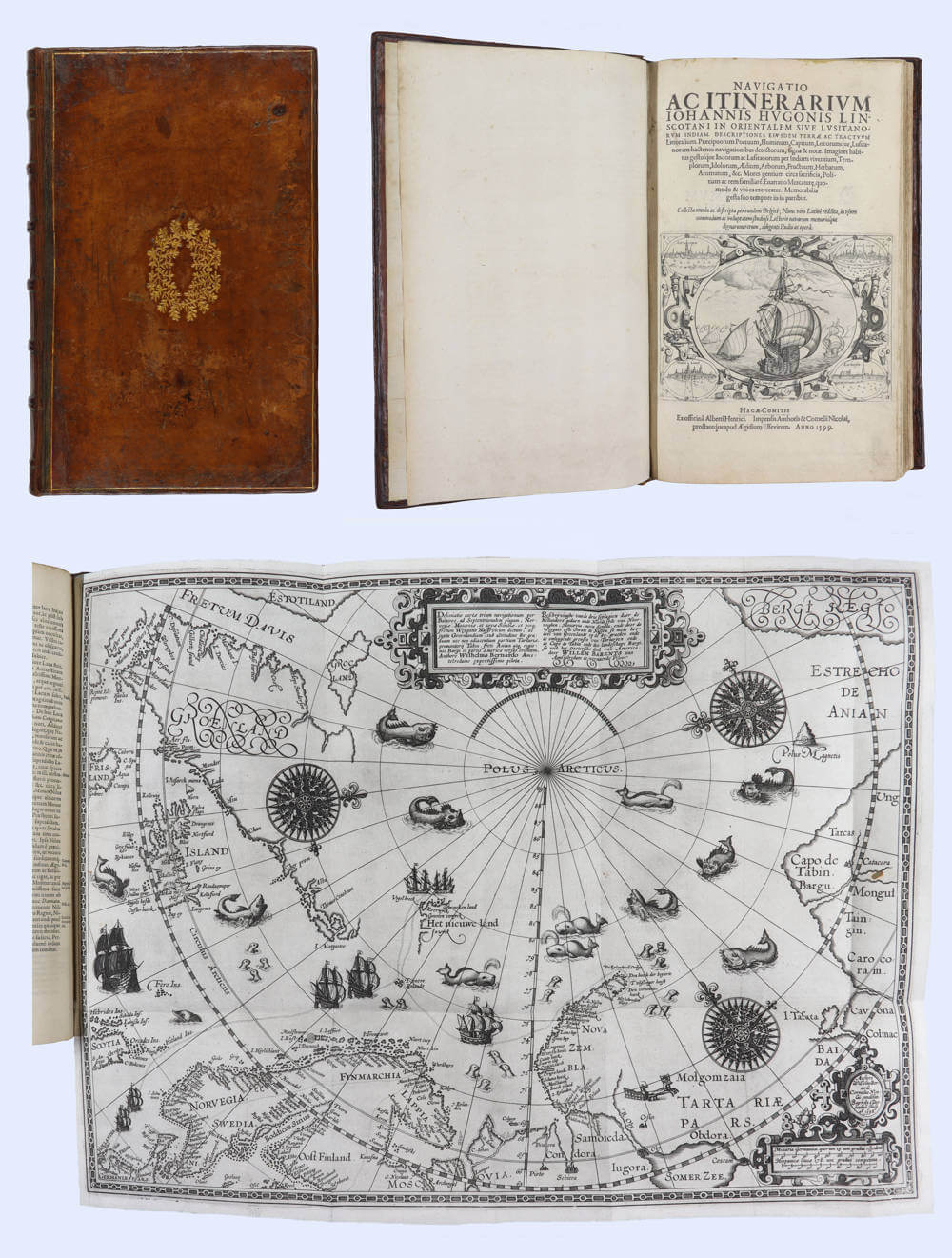
Quarto, 4 parts in 1 volume. First and only Latin Edition. engraved title, 42 engraved maps and plates, portrait of Linschoten, superb impressions of maps and views, original de luxe calf binding with gilted decorations. Very fine condition.
The celebrated 1599 Latin edition of Jan Huygen van Linschoten's "Navigatio ac Itinerarium Iohannis Hugonis Linscotani in Orientalem Sive Lusitanorum Indiam" is the first and only Latin printing of his seminal Itinerario (Dutch, 1596), and the most elaborate edition.
An abridged translation in four parts, it recounts Linschoten's six years in Portuguese Goa (1583?1589) and his Arctic voyages with Willem Barentsz (1594-1595). The work delivers unparalleled eyewitness descriptions of East Indian peoples, cultures, spices, and trade, together with precise Portuguese roteiros (sailing directions) that revealed alternative routes bypassing the Strait of Malacca, information critical to Dutch and English commercial expansion.
Lavishly illustrated with an engraved title, author portrait (with inset maps), 42 maps and plates (many folding or double-page, engraved by the van Doetecum brothers after Linschoten's drawings), and the landmark Barentsz Arctic map (only included here), it also covers West African coasts, America, and Spanish revenues. Extremely rare complete, this navigator's vade mecum broke Portuguese secrecy, informed the VOC's founding, and remains a cornerstone of early modern exploration literature and cartography.
Jan Huygen van Linschoten (1563-1611) served as the personal assistant and bookkeeper to the Archbishop of Goa from 1583 to 1589. After returning to the Netherlands, he issued his Itinerario in Dutch (1595/6). This 1599 Latin translation brought his invaluable observations to a wider European readership.
Printed in quarto, it features an engraved title, a full-page author portrait with four inset maps, and 42 engraved maps and plates (many folding or double-page) by the van Doetecum brothers. These include the double-hemisphere world map by Plancius, regional charts of the East Indies, Africa, and America, coastal views, and ethnographic plates showing Asian peoples, customs, flora, and fauna. Notably, this edition is the first and only that incorporates Willem Barentsz?s Arctic map from the 1594-1596 voyages in which Linschoten sailed.
Structured in four parts, the book offers Linschoten's firsthand account of Portuguese Goa, Indian society, customs, and the spice trade. A practical navigation guide provides detailed sailing directions derived from Portuguese pilots, detailing the Cape route and suggesting alternative passages such as the Sunda Strait. Additional sections cover Barentsz's Arctic expeditions and extend to the African coasts (Guinea, Congo, Angola, Monomotapa) and the Americas, with notes on Spanish colonial revenues.
Issued during the rise of Dutch seafaring power, the Navigatio ac Itinerarium delivered the navigational and commercial intelligence needed to challenge Portugal's monopoly on Eastern trade. Its maps and directions served as essential references for the Dutch and English East India Company. This enabled them to set sail for the Spice Islands and, ultimately, China and Japan, and was of such economic utility that, according to Church, and others, "it was given to each ship sailing from Holland to India" and soon became "the navigator's vade mecum for the Eastern seas" (Penrose).
Linschoten's detailed descriptions, maps and views are a unique cornerstone source for sixteenth-century Portuguese Asia.
Extremely rare when complete with all maps and plates. Cited as Sabin 41366. Subsequent editions and translations underscore its lasting influence. Fine contemporary copies are prized by collectors of travel, exploration, and early cartography.
Rarity
Extremely rare, even more so when complete with all maps and plates.
Significance
The best and most elaborate contemporary book about Portuguese India.
Condition description
Original de luxe calf binding with gilted decorations. Unusually fine condition.
Related Categories
Antique maps of the North Pole
Antique maps of the World
Antique maps of the East India Company
Antique maps of the Netherlands
Antique maps of Scandinavia
Old and Rare Books and Atlases
Antique maps of Australia
Antique maps of Japan
Antique maps of China
Antique maps of the Philippines
Antique maps of Southeast Asia
Antique maps of India and Ceylon
Antique maps of Korea
Antique maps of the Middle East
Antique maps of Asia
Antique maps of South America
Antique maps of America
Antique maps of Africa
Related Items


