Leen Helmink Antique Maps
Hugo Allard's rare map of the East Indies
The item below is on hold, but if you enter your email address we will notify you in case it becomes available, or if we have another example that is not yet listed, or as soon as we receive another example.

Stock number: 19787
Zoom ImageCartographer(s)
Allard
Title
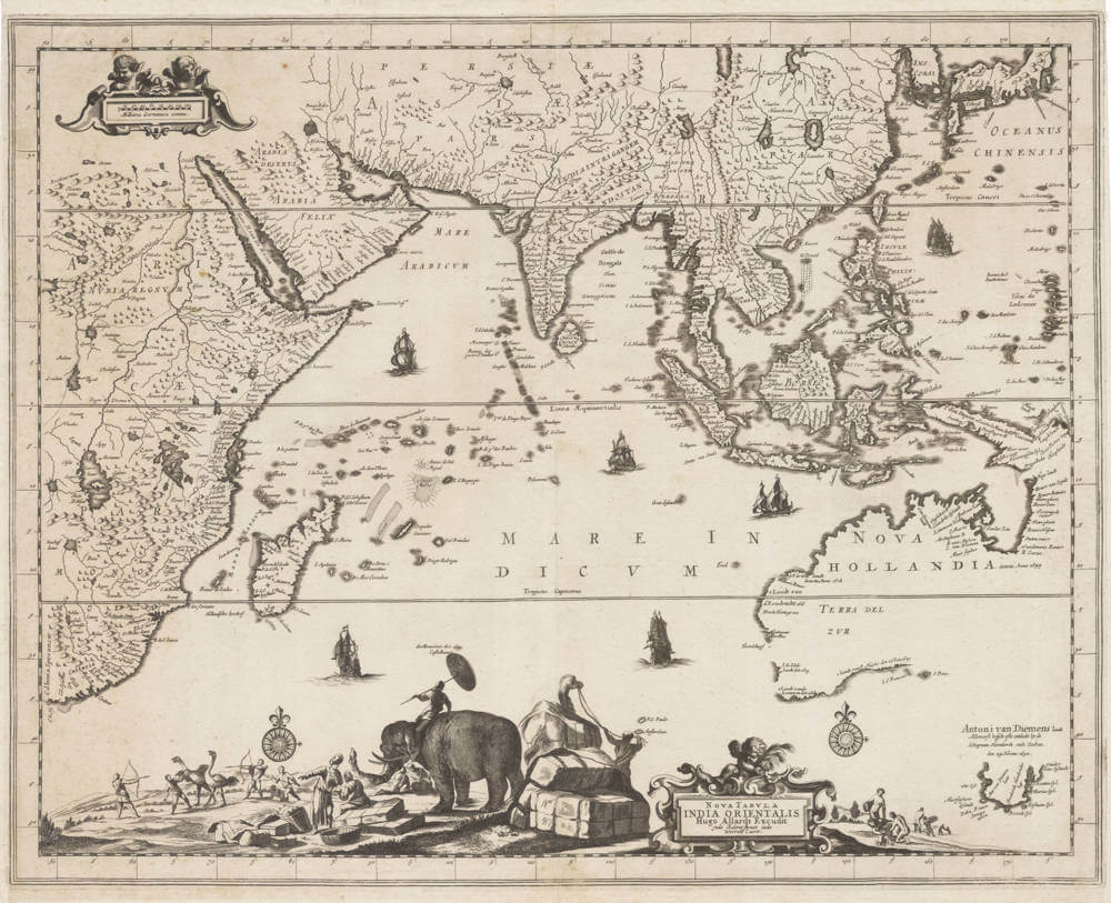
Nova Tabula Indiae Orientalis
First Published
Amsterdam, 1660
Size
56.2 x 44.7 cms
Technique
Condition
excellent
Price
This Item is On Hold
Description
Rare first state of 1660.
A highly spectacular and rare overview map of the East Indies, and a favorite of collectors.
Hugo Allard's exceptional map of the Orient is renowned for the decorative scenes along the bottom, resplendent with an elephant, camel, merchants and nomadic hunters chasing ostriches.
Here in the sought-after first state bu Hugo Allard Sr. The map was re-issued around 1697 in a second state with the impressum of his son Carel Allard.
The precise date is unknown, but it is considered to be from 1660, being one of the first printed maps to display the discoveries by Tasman.
The cartography of the East Indian islands: Insulae Indiae Orientalis
"The map is extremely decorative"
"A map that is much sought after by collectors"
(Parry)
Rarity
Allard's publications were sold as loose sheets and are therefore of greatest rarity. Few have survived and are prized by collectors. The map is lacking in most collections.
Significance
Hugo Allard's map of the East Indies "with the elephant" is famous and sought-after because of the spectacular ethnographic scenes. It is one of the earliest printed maps to reveal Tasman's discovery of Tasmania and the north coast of Australia.
Condition description
Strong and even imprint of the copperplate. No restorations or imperfections. An excellent collector's example.
Related Categories
Antique maps of the East India Company
Antique maps of Australia
Antique maps of Japan
Antique maps of China
Antique maps of the Philippines
Antique maps of Southeast Asia
Antique maps of India and Ceylon
Antique maps of Korea
Antique maps of the Middle East
Antique maps of Asia
Antique maps of Africa


