Leen Helmink Antique Maps
Anonymous world map after Petrus Plancius
The item below has been sold, but if you enter your email address we will notify you in case we have another example that is not yet listed or as soon as we receive another example.

Stock number: 19687
Zoom ImageCartographer(s)
Petrus Plancius (biography)
Title
Untitled world map in two hemispheres
First Published
Amsterdam, 1619
Size
40.0 x 56.5 cms
Technique
Condition
excellent
Price
This Item is Sold
Description
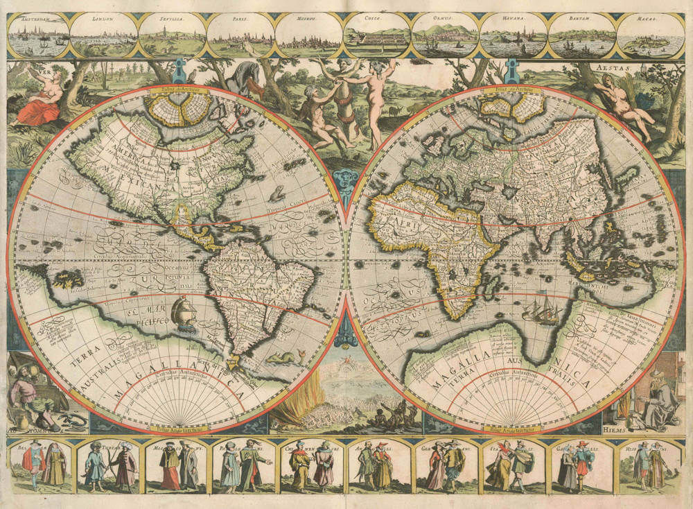
WORLD in two Hemispheres
Anonymous/Petrus Plancius, [c.1619]
Map of the world in two hemispheres, showing a reworked southern tip of South America after Le Maire’s voyage (1615–17). The borders were probably added when the copperplate was reworked. (Maritiem Museum ‘Prins Hendrik’, Rotterdam)
[Untitled map of the world]
– No bar scale
– [Amsterdam: c. 1619]
– 1 map: copper engraving; 40 × 56.5 cm (33.5 × 56.5 cm map only)
This map of the world is a compilation of Dutch origin. The map has no title, and no author or engraver is mentioned. The map image was copied almost entirely from Petrus Plancius’s 1594 map in two hemispheres with its characteristic four polar islands in the Arctic and the huge Southern continent forming a unit together with New Guinea. When compared with Plancius’s map, one of the few differences one sees is in the southern tip of South America, where the results of Le Maire’s expedition (1615–17) have been added. The reworking of the older copperplate can be clearly seen. The hemispheres, however, are framed by completely different decorative elements. Depicted in the central panel is the Temptation (top) and the Last Judgement (bottom), while in the corners, allegorical representations of the Four Seasons appear.
The map itself is framed by decorative borders at top and bottom, consisting of ten town views and paired national costumed figures. Top: AMSTERDAM; LONDEN; SEVILLA; PARIS; MOSKOU; CUSCO; ORUMS; HAVANA; BANTAM; and MACAO. Bottom: BELGÆ; TURCÆ; MOSCOVI; POLONI; CHINENSES; ANGLI; GERMANI; ITALI; GALLI; and HISPANI. These borders may have been added to the map later, perhaps when the southern tip of South America was reworked after Le Maire’s voyage.
Copies:
★ Berlin, Staatsbibliothek zu Berlin (B 3262)
★ Rotterdam, Maritiem Museum ‘Prins Hendrik’ (Engelbrecht Collection 100, in Casparus Lootsman, Nieuwe Water-werelt ofte zee-atlas, 1681)
★ Venezia, Biblioteca Nazionale Marciana
Literature:
Wieder (1925–33) II, p. 39, no. 39; Shirley (1983) no. 249
(Schilder Monumenta Cartographica Vol VI Map 5)
The Mapping of the World
Petrus Plancius — Anon (1)
Amsterdam?, c.1605.
400 x 565 mm.
[No title]
[Separate publication]
The actual date of this high-quality world map is uncertain, and it may be of composite origin. It bears no title, dedication, or indication of author. There are two hemispheres bordered by ten city views at the top and ten vignettes of paired national figures along the bottom.
The hemispheres themselves were recognised by Wieder as deriving from Petrus Plancius but the map was erroneously listed as a ‘reprint’ of Plancius’ world map of 1594, with identical title. The borders may have been added to the map later: perhaps when the land off the southern tip of South America was redrawn after 1617, as appears on all known copies of the map. One or two separate examples of the map are recorded, possibly from a re-issue in the Nieuwe Water Werelt of Caspar Lootsman, published in Amsterdam in 1681. Copies I have consulted in the Maritime Museum in Rotterdam and the Mellon Collection in Virginia both contain this map. It is not impossible that examples of the hemispheres in their earliest state may still turn up to substantiate the supposed original date of c.1605.
Biblioteca Nazionale Marciana, Venice, Vol: 70736 (168.d.24).
Wieder, vol. II, p. 39, item 39.
(Shirley map 249 plate 196)
Rarity
Of exceptional rarity. Lacking in all collections.
Significance
The map is only one of nine Dutch single-sheet world maps with decorated borders that were published in the 17th Century.
Petrus Plancius (1552-1622)
Born as Peter Platevoet in Flanders, Petrus Plancius studied abroad and became a theologian and a mapmaker.
He produced some globes and maps, including a well-known world map in 1592. He had a great influence on the Dutch Asian expeditions.
Early Years
Peter Platevoet was born in 1552 in the Flanders village of Dranouter. Little is known about his childhood, but it seems that his parents became Protestants. Platevoet studied theology, history, and languages in Germany and England. In England he probably learned about mathematics, astronomy, and geography. When he was older, Platevoet Latinized his name, as was the custom among savants at that time.
In 1576 he became a preacher in West-Flanders, a province in Belgium, and later that year he went to Mechelen, Brussels, and Louvain. In the 1580s he stayed in Brussels for a long time, but when the city surrendered to the duke of Parma, King Philip II of Spain’s governor-general in the Netherlands, in 1585 Petrus Plancius fled to the north. He lived in Amsterdam and became a pastor of the Dutch Reformed Church. From December 1585 until his death on 15 May 1622, he fulfilled his job as preacher. Plancius was a fervent Contra-Remonstrant and discussed many theological issues.
In addition to his thorough knowledge of the Holy Bible, he was well-grounded in the study of cosmography, geography, and cartography. He was not only one of the most talked-about preachers in the Dutch republic, but also one of the important mapmakers of his time.
Early Publications
Petrus Plancius was the first caert-snyder (map cutter) in the Dutch republic to produce waxed grid maps. Therefore, on 12 September 1594 he received a patent for the publication and distribution of the world map for twelve years from the States-General. He was, together with the Flemish engraver and map-maker Jodocus Hondius and the brothers Van Langren, one of the first makers of celestial globes in the Netherlands. His first globe was produced in 1589, a revision of an earlier celestial globe. Among his revisions were four additions to the southern sky: the two Magellanic Clouds (they were unnamed on the globe) and two new constellations, Crux and Triangulus Antarticus. Their positions were taken from reports of explorers.
In 1590 Petrus Plancius made five terrestrial maps for a Dutch edition of the Holy Bible. Two years later he made a well-known world map: Nova et exacta terrarum orbis tabula geographica ac hydrographica (New and exact geographical and hydrographical map of the world). This map contained celestial planispheres in the upper corners on which he added two additional constellations.
Asian Expeditions
Petrus Plancius was one of the driving forces behind the first Dutch expeditions to Asia, assisting with preparations and providing instruction. To avoid encounters with Spain and Portugal, which were already sailing to the East Indies around southern Africa, Plancius decided to try a northeast route around Asia. He supplied maps for the voyage and advised the fleet commander, Willem Barents, in celestial navigation. The northeast voyages of 1594 and 1595 were failures, but a third attempt was made in 1596. It was on that last expedition that Barents’s ship got stuck in the polar ice, and the crew had to spend the winter in Nova Zembla, an island northwest above Russia, in what came to be called the Barents Sea. Late in the spring of the next year, the crew was able to sail south in two small boats. Barents died on the return voyage; the survivors arrived at Amsterdam in November 1597, not having found a northeast passageway.
In 1595, together with Barents, Plancius published a book titled Nieuwe Beschrijvinghe ende Caertboeck van de Middelandtsche Zee (New description and map book of the Mediterranean Sea). In this work he designed a map that was engraved by the well-known globe- and map-maker Hondius.
Because the northeast sea route around Asia did not seem very promising, even before the third voyage a group of Dutch merchants had financed a southern expedition. Plancius again helped with the planning and used the opportunity to conduct scientific research. A theory in the late sixteenth century claimed that a compass needle’s variation from north (its declination) would enable one to determine longitude. Plancius developed his own theory to ascertain longitude at sea by means of magnetic variation. To test that theory during the southern voyage, Plancius taught junior merchant Frederik de Houtman how to measure and record compass declinations. It is known that the method developed by Plancius was used from 1596 onward by mariners.
Plancius also used the voyage to discover southern stars that were not visible from Europe. He taught navigators, especially Pieter Dircksz Keyser, but also other sailors, how to measure star positions with an astrolabe and instructed them to chart the southern sky. From ship records of 1596 it is known that the astrolabe was used to measure the declination of the southern stars.
The Dutch southern expedition, known as the Eerste Shipvaart, or First Voyage, set sail from the port of Texel in April 1595. It reached the East Indies in 1596 and returned to Texel in August 1597. Plancius asked Keyser, the chief pilot on the Hollandia, to make observations to fill in the blank area around the south celestial pole on European maps of the southern sky. Keyser died in Java the following year, but his catalog included 135 new stars arranged in twelve new constellations. Most of them were invented to honor discoveries by sixteenth-century explorers. They were first published on a 1598 celestial globe made by Hondius.
After the foundation of the VOC (Verenigde Oostindische Compagnie, or East India Company) in 1602, Plancius became its first mapmaker. During the first quarter of the seventeenth century, he seemed more interested in preaching than in cartography and cosmography. But still, some of his maps were published during that time. In 1607 he produced a large revised world map. In 1612 he created a celestial globe, and later he designed an Earth and another celestial globe (1614 and 1615), both brought out by the well-known publisher Petrus Kaerius. His contemporaries described him as one of the greatest geographers of his time.
Bibliography
A complete bibliography of Plancius’s work, with descriptions of much of his maps and publications, is Günter Schilder, Monumenta Cartographica Neerlandica, Vol. VII, Cornelis Claesz (c. 1551–1609): Stimulator and Driving Force of Dutch Cartography, Alphen aan den Rijn, Netherlands: Canaletto/Repro-Holland, 2003.
(encyclopedia.com)
Related Categories
Related Items


 by Ruscelli")

