Leen Helmink Antique Maps
Antique map of the World by Chatelain

Stock number: 19399
Zoom ImageCartographer(s)
Chatelain
Title
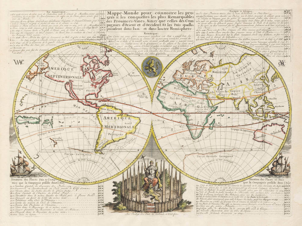
Mappe-Monde pour connoitre les progres & les conquestes les plus Remarquables des Provinces-Unies, Ainsy que celles des Compagnies d'Orient et d'Occident. Et les Pais quelles possedent dans l'un et dans l'autre Hemisphere
First Published
Amsterdam, 1719
Size
33 x 45.5 cms
Technique
Condition
pristine
Price
$ 1,250.00
(Convert price to other currencies)
Description
Attractive map of the World, in double hemisphere projection.
The map illustrates the successes of the Dutch East India Company (VOC) and Dutch West India Companie (WIC) throughout the world.
The geography shows Australia, Tasmania and New Zealand with the Tasman discoveries, a large unknown southland and California as an Island. The northern Pacific has a large companies land, extending from Asia to America.
A west india and east indiamen are shown at the lower corners of the map.
The sailing routes of the East India Company are drawn in, as well as the Pacific routes of the Dutch circumnavigators Olivier van Noord and Jacques LeMaire.
In the corners, 47 index numbers and grid coordinates refer to places on the world map where important Dutch events or VOC strongholds are located,
The center bottom shows the "Hollandse Tuin" ("Dutch Garden"), a metaphor for the highly defended low countries homeland. The Dutch lion is shown twice, once in the Dutch Garden and again in an emblem in the upper center.
A decorative world map from Chatelain's monumental 7 volume Atlas Historique, one of the most important works of the early 18th Century.
Curiously, it is the only world map that is dedicated to the Dutch East India and West India Companies.
Related Categories
Related Items


 by Ruscelli")
