Leen Helmink Antique Maps
Early navigation chart of Port Jackson
The item below has been sold, but if you enter your email address we will notify you in case we have another example that is not yet listed or as soon as we receive another example.

Stock number: 19541
Zoom ImageCartographer(s)
British Admiralty
Title
Port Jackson
First Published
London, 1859
This Edition
London, 1872
Size
63 x 96 cms
Technique
Condition
excellent
Price
This Item is Sold
Description
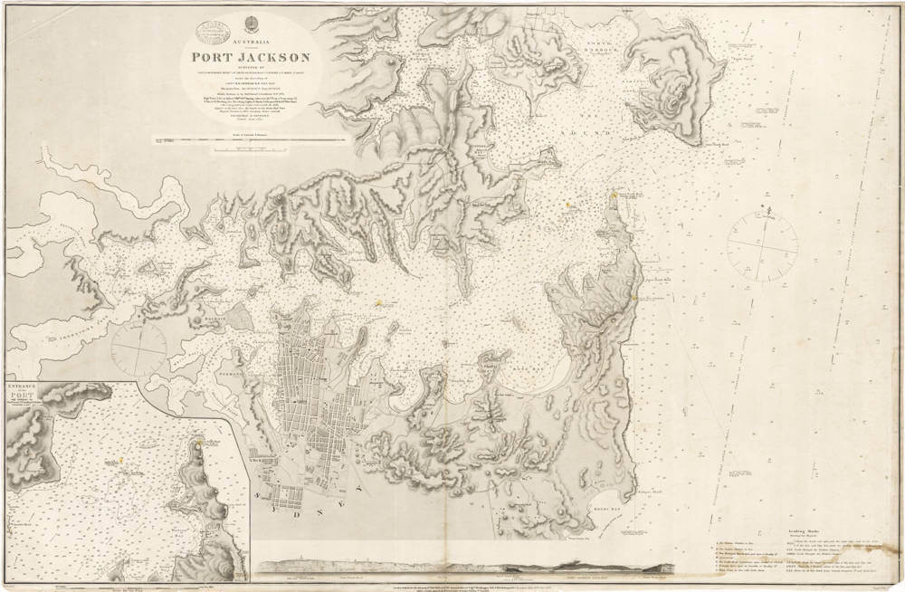
Australia - Port Jackson / Surveyed by Lieut. J. Hutchison etc ... 1857
Hydrographic Office
Price Three Shillings
With the oval shop stamp of "J. DONNE ADMIRALTY CHART AGENT And NAUTICAL BOOKSELLER 120 ELIZABETH ST MELBOURNE"
London Published at the Admiralty 11th Feb 1859 under the superintendence of Capt Washington R.N. F.R.S. Hydrographer.
Corrections June 1870. Dec 1872.
Engraved by J. & C. Walker
Very large and detailed navigation chart for Port Jackson (Sydney Harbour).
With a large scale inset chart of the entrance of the port in the lower left, as well as a profile view of the entrance along the bottom of the chart.
The chart has many soundings in fathoms, as well as magnetic bearings.
Condition
No restorations or meaningful imperfections. Very authentic look and feel. Clear signs of use, overall in excellent condition.
Related Categories
Related Items


