Leen Helmink Antique Maps
Unrecorded central title strip for wall map of the world by Romeijn de Hooghe and Johannes Loots.

Stock number: 19535
Zoom ImageTitle
Nova Totius Orbis Tabula
First Published
Amsterdam, 1707
Size
22.0 x 53.5 cms
Technique
Condition
excellent
Price
$ 3,750.00
(Convert price to other currencies)
Description
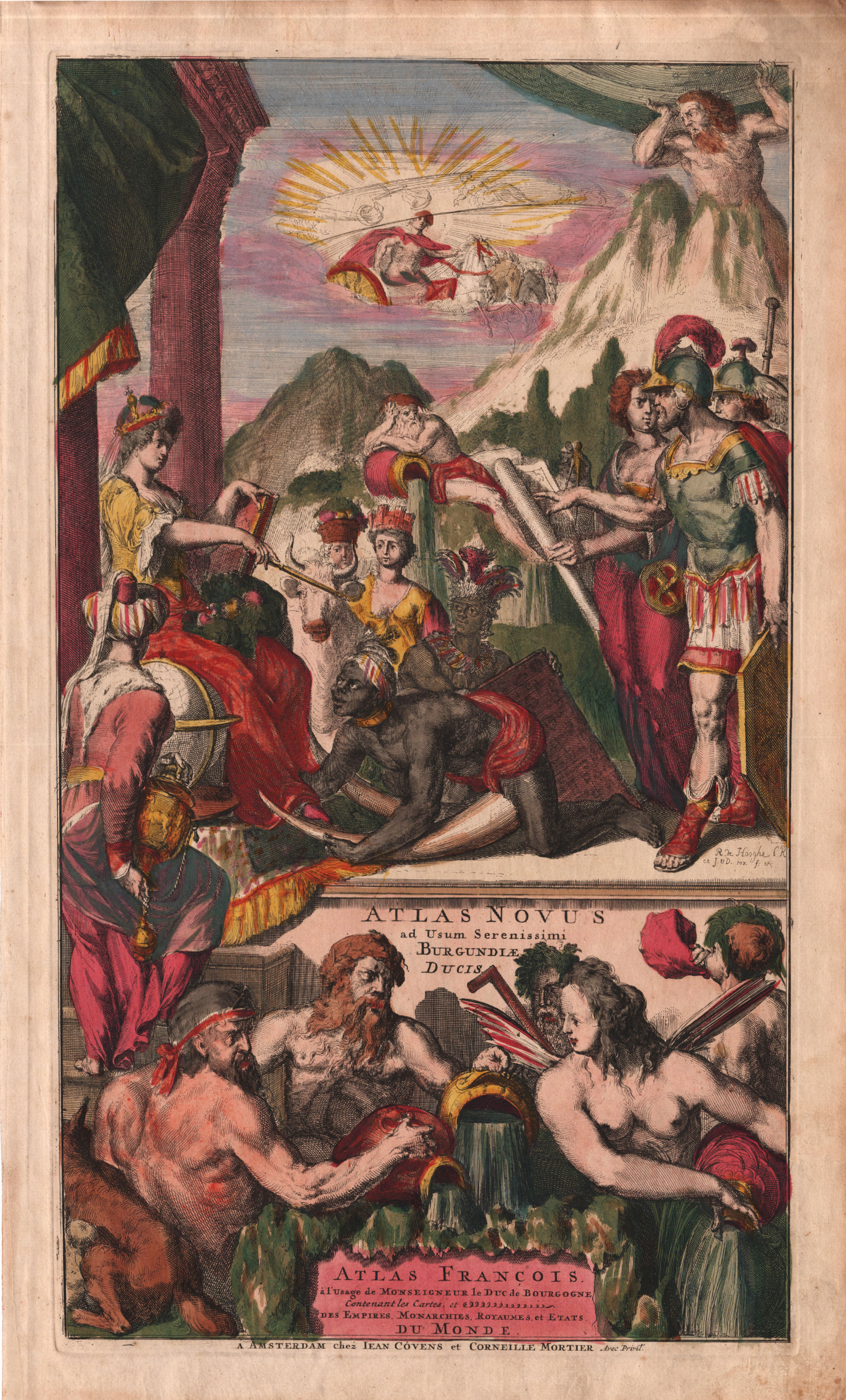
Large title strip segment for a wall map of the world by Romeyn de Hooghe
The strip was made for a wall map of the world by Romaijn de Hooghe and Johannes Loots of 1707 or 1708, which is only known in one incomplete example.
Copper plate etching.
Size of printed area height x width 22.0 x 53.5 cm.
The etching is the central segment (of three) of a title for a wall map of the world.
It has a banner with the words
N: TOTIUS ORBIS TABU[LA]
[ New map of the whole world ]
It shows an allegory of a Roman Europa with the classical stream/river gods (water deities) Donau, Rhine (with oak leafs) and Tiber. In the back to the right is Triton, God of the Sea, with a shell as his trumpet.
The "Kangaroo" at the left is the wolverine that suckles Romulus and Remus, founders of Rome.
At the left is part of an allegory of Asia (with camel).
The identical allegorical scene is found on a title page of Covens and Mortier, signed by Romeijn de Hooghe, published around the same time.
The evidence that it belongs to the wall map is strong:
- Both are etched by Romeyn de Hooghe
- Both are the same date ca 1707-1708
- Both are part of a hitherto completely unknown wall map of the world
- Both have the same decorative themes, with mythological gods and continents
- When displayed at the same scale, the images and relative sizes match very well.
- Both use the identical iconology of the title page for the Covens and Mortier atlas, etched and signed by Romeijn de Hooghe.
Condition
Thick paper. Dark and even imprint of the copperplate. No restorations or imperfections. Pristine collector's condition.
The back of the large paper sheet has been re-used almost a century later, in 1803 in Amsterdam, for a proof print from a Dutch edition of Cook's voyages. Large paper sheets were relatively expensive and often re-used for proof printing.
Romeyn de Hooghe (1645-1708)
During his lifetime, the etcher Romeyn de Hooghe (Amsterdam 1645 – Haarlem 1708) was renowned as the most important graphic artist of its era. “Who wants to learn the art of etching, should become an apprentice of the very well educated Romeyn de Hooghe”Inleyding tot de hooge schoole der schilderkonst (Introduction to the academy of the art of painting).
This enthusiasm for the work of De Hooghe was still unchanged in the twentieth century. The famous Austrian art historian Otto Benesch considered Romeyn de Hooghe as “the most genius Dutch illustrator and one of the most important etcher of all times. His work united the universality of baroque, of which in Holland he was the last representative of European stature ...” [Otto Benesch, 1964, p. 368].
The versatility and high artistic quality are characteristic of the works of Romeyn de Hooghe. His illustrations and loose prints cover all possible subjects. De Hooghe illustrated books of every conceivable genre. In the area of loose prints, special attention is attracted to the numerous news prints, allegories, portraits, maps, topographical prints and costume prints. A good insight in his many-sided work is offered by the publications of Landwehr (1970 and 1972).
Romeyn de Hooghe also designed and etched numerous title pages of books. One of the oldest of his hand is the frontispiece of Nicolaas Witsen’s Aloude en Hedendaegsche Scheeps-Bouw en Bestier (1671). Witsen was the leading authority in the area of ship building and ship design in the late 17e century, and his profusely illustrated publications were famous internationally.
A remarkable aspect of the style of Romeyn de Hooghe is the extremely fluent and smooth manner of drawing and etching. The illustrations are filled with many human figures that suggest action: everywhere is activity and motion. Seen from a distance, the crowds have a shaping quality; a closer look reveals however a huge amount of narrative details. Especially striking are the facial and emotional expressions of the people who are depicted. In much of his work he combines often newly invented allegorical elements, inspired by classical antiquity and the Bible, with more concrete and contemporary representations. With his pictorial technique he tried to achieve emotional involvement from the spectator. This effective combination of erudition and inventiveness, of imagination and sensationalism, made his work irresistible for his contemporaries and has lost none of its charm today.
In addition to graphic art, Romeyn de Hooghe was closely involved in the design and manufacture of cartographic works. Notable examples are the large and decorative overview wall maps of Delft (1675-78), Haarlem (1688-89), Rotterdam (1694) and the Hoogheemraadschap (Water Board) of Rijnland (1687). These maps consist not only of a cartographic image, but are surrounded by city profiles, coat-ofarms of governors, decorations, separate title banners etc. Another famous example is the large portolan chart of
maritime cartography of the 17th century.
Romeyn de Hooghe rapidly developed himself to the most productive and the most popular etcher of his time, and he produced a great amount of prints for various purposes, from small book illustrations to luxury print series on large format. Despite all this, very little of his work has come to us in colour, especially in the form of his loose prints or loose charts.
Literature
Otto Benesch, Meisterzeichnungen der Albertina, Salzburg, 1964.
John Landwehr, Romeyn de Hooghe (1645-1708) as book-illustrator. A bibliography. Amsterdam, 1970.
John Landwehr, Romeyn de Hooghe the etcher. Contemporary portrayal of Europe 1662-1707. Leiden, 1972.
Georges Keyes (ed.), Mirror of Empire. Dutch marine art of the seventeenth century. Minneapolis: The Minneapolis Institute of Art, 1990.
Günter Schilder, A manuscript sea atlas, drawn by Romeyn de Hooghe in 1681. In: Publicacoes do Centro de Estudos de Cartografia Antiga. Vol. 130 (Coimbra 1981) 17 pp.
Günter Schilder, Dutch wall maps of the 16th, 17th and 18th Century. To be published, 2024.
Günter Schilder, personal communication.
Henk van Nierop et. al. (eds), Romeyn de Hooghe. De verbeelding van de late Gouden Eeuw. Zwolle: Waanders Uitgevers / Amsterdam: Bijzondere Collecties van de Universiteit van Amsterdam, 2008. Exhibition Catalogue.
Henk van Nierop, The Life of Romeyn de Hooghe 1645-1708. Amsterdam University Press, Amsterdam, 2018. Exhibition Catalogue.
Johannes Loots (1665/66-1726)
The publisher Johannes Loots was born in Amsterdam in 1665 or 1666. He lived on the Zeedijk and his profession was that of nautical instruments maker. His wife was Sara Swigters who, as we will see further on, was not without means. Both were Catholic. Around 1693, he opened a shop in the Nieuwebrugsteeg, In de Jonge Lootsman, the fifth house from the New Bridge, on the right hand side. This precise notation was important because two colleague-ship-chandlers lived on the same street: Johannes van Keulen, at the corner near the New Bridge In de gekroonde Lootsman and Hendrick Doncker, in the third house from the New Bridge, In ’t Stuurmans Gereedschap.
In the latter shop, Johannes Loots had served his apprenticeship as a maker of mathematical and nautical instruments. The Guild of Booksellers, after some hesitation, accepted him as a member on 5 May 1693. The first record of Johannes Loots’ activities as a chart publisher is dated 1 April 1695. In anotary contract of that date he made an agreement with the engraver Antoni de Winter for the cutting of a certain number of charts at their joint risk. Presumably: these charts were used for Loots’s first sea-atlas: Het nieu en compleet Paskaart Boek van de Noord en Oost Zee, 1697.
His partner, Antoni de Winter, behaved rather unfair because he associated himself, without the knowledge of Johannes Loots, with the land surveyor and mathematician, Claas de Vries in order to make a large sea-atlas composed of 150 charts with increasing latitudes. The notary contract, dated June 1696, stipulates that the atlas should be published at their joint risk and that the preparations should not be revealed to any person. But Loots did not remain ignorant of this project and on 6 April 1698 he joined the two partners in their undertaking. In the notary contract of that date the atlas project is then described as a chart book with ca. 200 maps, all on the Mercator projection.
A privilege for the planned atlas was granted on 2 July 1698 and the atlas was even advertised in the Amsterdamsche Courant of 28 August 1698; the large atlas as such, however, was never published. During 1698-1707, various quantities of maps have been sold as atlases but the complete work never appeared. The partnership was dissolved on 17 September 1707 at which occasion Claas de Vries sold his share in the copperplates to Gerard van Keulen, with charts of the Channel and one of the entrance of Hull harbour. The largest copies of Loots’s sea- atlas known are preserved in the Amsterdam University Library (124 charts) and in the Bibliotheque Nationale, (151 charts) but the latter contains only 75 charts published by Johannes Loots. Most of the charts must have been drawn by Claas de Vries between 1695-1707. They were excellent charts indeed, much better than the charts published by Loots after that date, when the rear-admiral Christoffel Middagten made his appearance as a chart maker. Another set of charts was printed from plates obtained from Jacob Robijn. During 1706-1717, Loots published charts of the Northern Navigation drawn by Middagten. These were not based on the Mercator projection (with one exception) and less correct in the outlines of coasts, etc. The rear-admiral also edited the text for Loots’ Nieuw Groot verbeterde Straats Zeeboek, 1723. In despite of strong competition (van Keulen, Doncker, Lootsman), Johannes Loots his shop prospered. This can be deduced from Loots’s purchase of a house on 29 October 1701. This house was situated at the Binnen Amstel and was sold for 3550 guilders. A large part of Loots’s revenues came from selling the famous manual on navigation: Schatkamer ofte Konst der Stuurlieden, by Claas de Vries, a revised edition of the book with the same title written by Abraham de Graaf. Apart from this textbook, various pilot guides were published by Johannes Loots. We find them listed in the inventory of the shop, drawn up after the death of Isaac Swigters in 1750. This inventory also lists a lot of 464 copperplates which gives us an idea of the extent of the chart trade. This figure is much higher than the number of charts known.
When Johannes Loots died in 1726, his wife Sara Swigters continued the business. She was assisted by her brother Isaac who had been a member of the Bookseller Guild since 1717. From 1726 on the books and charts sold carried the address: Sara Swigters, widow of Joannes Loots & Isaac Swigters. After the death of Sara Swigters in 1743, her brother continued with the shop until his death in 1750. The books were then sold to Johannes van Keulen and the charts to Joachim Hasebroek, successor of Jacob Robijn.
Literature
D. Gernez: Le libraire néerlandais Johannes Loots et sa maison d’éditions maritimes, published in Communications de l’académie de Marine de Belgique, Tome VIII, 1954, pp 23-71.
Cornelis Koeman. Atlantes Neerlandici (1967-71), Volume IV.
Related Categories
Related Items


