Leen Helmink Antique Maps
Early sea chart of the Philippines by Homann Heirs and Georg Maurice Lowitz, after Pierre Murillo Velarde
The item below has been sold, but if you enter your email address we will notify you in case we have another example that is not yet listed or as soon as we receive another example.

Stock number: 19475
Zoom ImageCartographer(s)
Title
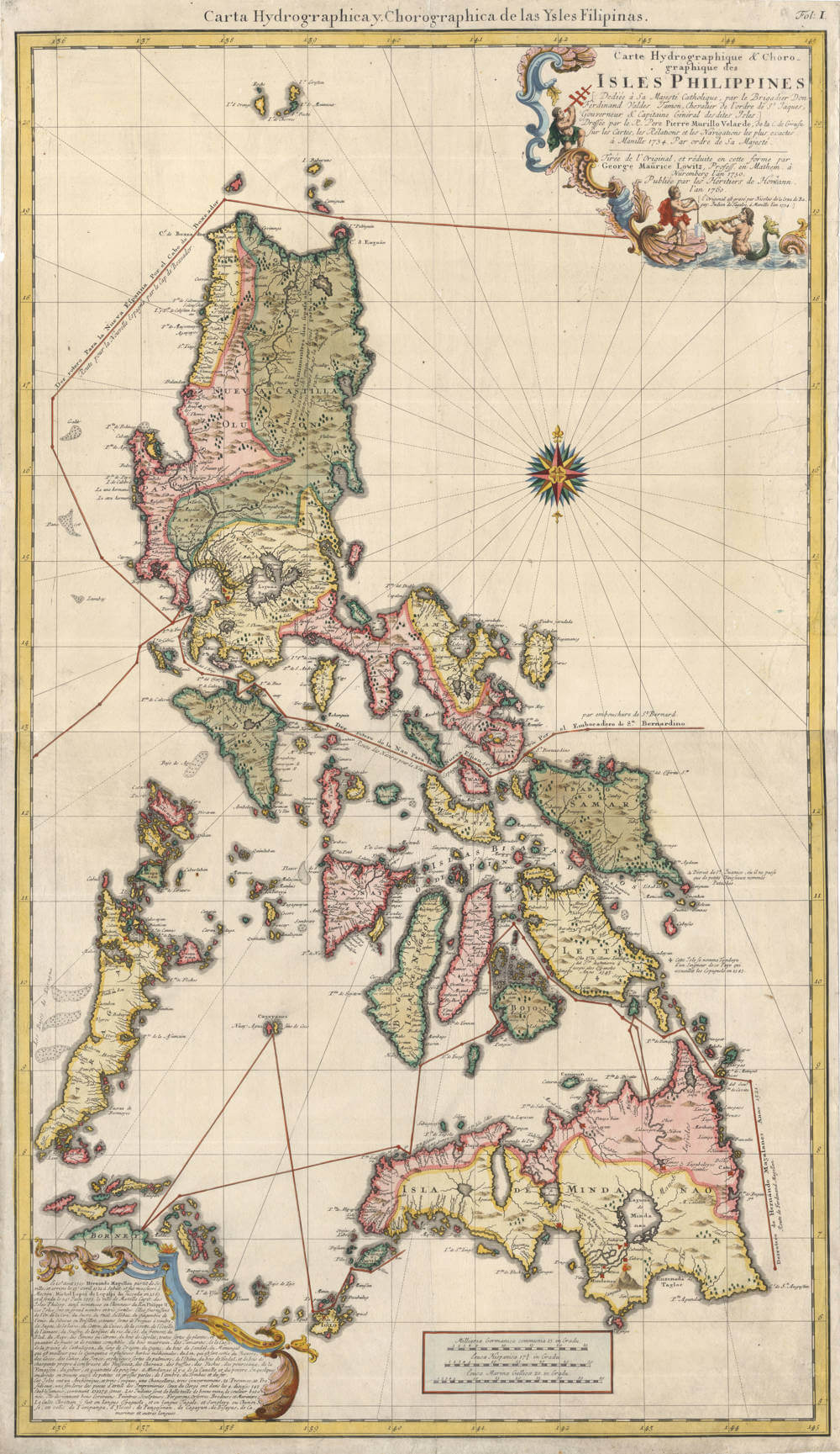
Carte Hydrographique & Chorographique des Isles Philippines Dediee a Sa. Majeste Catholique, par le Brigadier Don Ferdinand Valdes Tamon . . . Dressee par le R. Pere Pierre Murillo Velarde . . . Tiree de la Original, et reduite en cette forme per George Maurice Lowitz . . . 1760
First Published
Nuremberg, 1760
Size
93.0 x 53.5 cms
Technique
Condition
excellent
Price
This Item is Sold
Description
Very large showpiece sea chart of the Philippines, in two sheets, issued by Homann Heirs. The chart is based on a reduced design by Georg Maurice Lowitz of the 1734 Murillo Velarde map of the Philippines.
This sea chart includes the 1521 tracks of Magellan, as well as the incoming and outgoing tracks of the annual Manilla galleons.
Charting the Philippines Islands
Pedro Murillo Velarde (1696 - 1753)
George Maurice Lowitz
Nicolas De La Cruz De Bagay/
Francisco Suarez
Carte Hydrographique & Chorographique des Isles Philippines
[Translation of the text in the upper right cartouche of the map]
Dedicated to the Catholic Majesty by the Governor-General Fernando Valdés Tamon ...
Drawn by the Jesuit Pedro Murillo Velarde ...
Copied from the 1734 edition with some changes and in reduced format by George Maurice Lowitz, Professor of Mathematics in Nuremberg in the year 1750.
Published by the firm of Homann Heirs in 1760.
[the original was engraved by Nicolas de la Cruz de Bagay, a Tagalog Indio, in Manila in 1734]
This coveted 1760 reissue of Murillo Velarde’s 1734 Carta Hydrographica shows the island contested by China -- Panacot (Scarborough Shoal) off Zambales.
Various shipping routes around and between the islands are indicated as the map also served as a sea chart. On the island of Mindanao near the Laguna de Mindanao, there is a Spanish inscription
Aqui estuvo S. Franc[isco] Xavier
[ St. Francis Xavier was here! ]
This bolstered the 18th century fond belief that the “Apostle of the Indies” set foot in Mindanao. The upper right and lower left corners are enhanced with decorative cartouches.
Murillo Velarde asked the printer Nicolás de la Cruz de Bagay to engrave both the 1734 and 1760 maps. Murillo Velarde expressed his admiration for the talent of the Indios (Filipinos) in the arts and in the passage found in the lower left corner of the map:
…The Indios [Filipinos] are well-built, have fine features and are dusky in complexion. They become good writers, painters, sculptors, blacksmiths, goldsmiths, embroiderers, and sailors. The Christian religion is taught in Spanish, Tagalog, Sangley or Chinese, Pampango, Ilocano, Pangasinan, Cagayano, Visayan, Camarines and other languages.
The last copy in auction was in 2020 for hammerprice PHP 700,000 plus auction fees (PHP 800,000/USD 14,000 including fees), see
Leon Gallery Auction The Kingly Treasures Auction 28 Nov 2020 lot 65.
Significance
This chart is one of the earliest obtainable versions of the iconic Murillo Velarde map, which itself is unobtainable and of extremely high value. The Homann/Lowitz chart is a key item for any Philippines collection.
Condition description
Printed on two sheets of paper, here joined into one large chart to allow for the best possible presentation. Gorgeous condition, stunning original colour.
Johann Baptist Homann (1664-1724)
Johann Christoph Homann (son) (1703-1730)
Homann Heirs (1730-1852)
The Homann Family of Publishers: Pioneers of 18th-Century German Cartography
The Homann family stands out as one of the most significant map-making dynasties in 18th-century Germany, particularly in Nuremberg, where they established a formidable presence in the world of cartography. At the heart of this legacy was Johann Baptist Homann, born in 1664 in Oberkammlach, a small town in Bavaria. Initially trained for a career in the church at a Jesuit school, Homann's life took a profound turn when he converted to Protestantism in 1687, which led him to Nuremberg, where he would lay the foundations of his future enterprise.
Homann's journey into cartography was not immediate. After his conversion, he worked as a notary in Nuremberg but soon found his calling in engraving and map-making. His skills were honed in Vienna from 1693 to 1695, where he perfected the art of copper plate engraving. Returning to Nuremberg around 1698, Homann established his own publishing house in 1702, which would soon become a cornerstone in German cartography. His first major work, the "Neuer Atlas" published in 1707, marked the beginning of a prolific output that would see him rise in both reputation and influence.
In 1715, Homann was appointed Imperial Geographer by Emperor Charles VI, an honor that underscored his significance in the field. This appointment not only elevated his status but also provided him with imperial printing privileges, which protected his work from unauthorized replication. That same year, he was also admitted into the Prussian Academy of Sciences in Berlin, further cementing his scholarly credentials. His masterpiece, "Grosser Atlas über die ganze Welt" (Grand Atlas of all the World), published in 1716, showcased his mastery over both the art and science of map-making, featuring detailed and ornate maps that were both functional and aesthetically pleasing.
Upon Johann Baptist Homann's death in 1724, his son, Johann Christoph Homann, took over the business. However, Johann Christoph's tenure was short-lived as he passed away in 1730. The firm then transitioned into the hands of Homann's heirs under the name "Homann Erben" (Homann Heirs), managed by trusted associates Johann Michael Franz and Johann Georg Ebersberger. This continuity ensured that the legacy of high-quality map production continued well into the 19th century, with the company maintaining its reputation through the publication of atlases like the "Atlas Geographicus Maior" in 1780 and the "Atlas Homannianus" in Amsterdam from 1731 to 1796.
The Homann family's contribution to cartography was not just in the volume of their work but in their approach. They revolutionized map-making by focusing on both detail and accuracy, which was somewhat novel compared to the more decorative maps of their Dutch, French, and English contemporaries. Their maps were not only used for navigation but also for educational purposes, reflecting the Enlightenment's emphasis on knowledge dissemination. The collaboration between Johann Baptist Homann and Johann Gabriel Doppelmayr on celestial maps further diversified their portfolio into astronomy, producing works like the "Atlas Coelestis" in 1742.
One of the most notable works from the Homann Heirs is the two-sheet sea chart of the Philippines, produced in 1760 in collaboration with Nuremberg professor George Maurice Lowitz. This map, titled "Carte Hydrographique & Chorographique des Isles Philippines," represents an exceptional piece of nautical cartography for its time. It provides a detailed depiction of the Philippine archipelago, including the major islands like Luzon and Mindanao, along with navigational aids like compass roses, rhumb lines, and a wealth of information on maritime routes, sea depths, and coastal features. The map also reflects the geopolitical knowledge of the era, showing Spanish influence in the region. This chart was both a navigational tool for sailors and a testament to the Homann Heirs' commitment to advancing the accuracy and detail in cartography.
Their business strategy was also ahead of its time, capitalizing on lower production costs in Germany compared to other countries, thus gaining a competitive edge in the market. The Homann maps often included innovative features like detailed city plans within larger regional maps, catering to both scholarly and commercial audiences.
The legacy of the Homann family extends beyond their lifetime; their maps are now cherished by collectors and historians for their historical and artistic value. The Homann Heirs continued until 1852, leaving behind a vast collection of maps that chronicle not just geography but the evolution of cartographic art and science in the 18th century. The Homann family's work from Nuremberg serves as a testament to the era's cultural and scientific achievements, encapsulating the spirit of an age where exploration and knowledge were paramount.
George Maurice Lowitz (1722-1753)
Georg Maurice Lowitz: The Scholar, Astronomer, and Cartographer
Georg Maurice Lowitz, born Georg Moritz Lowitz on February 17, 1722, in Fürth, Germany, was a distinguished figure in the realms of astronomy, geography, and cartography during the 18th century. Originating from a humble background in a handworker's family, Lowitz's career trajectory was marked by his autodidactic pursuit of knowledge, which saw him rise to prominence in several European academic and scientific circles.
Lowitz initially learned the trade of goldsmithing from Ferdinand Friedrich Waechtler, a globe maker in Fürth, but his passion soon shifted towards the sciences. His intellectual curiosity led him to work with the renowned Homann's cartographic office in Nuremberg, where he collaborated with Tobias Mayer, another significant figure in science. Here, he developed his skills in map-making and began contributing to the field of astronomy by engaging in mathematical and physical studies during his free time.
In 1751, Lowitz's self-taught capabilities earned him a position as a professor of mathematics at the Egidiengymnasium in Nuremberg. His academic career flourished, leading to further professorships; he became a professor of practical mathematics at the University of Göttingen in 1755 and later took charge of the Göttingen Observatory in 1762. His work in Göttingen was notable, though his time there was marked by challenges in establishing his authority alongside more established scholars like Mayer.
Lowitz's contributions to astronomy were particularly evident when he was part of the expedition to observe the 1769 transit of Venus from Gureyev (now Atyrau) near the Caspian Sea. His observations were conducted in collaboration with the Russian Academy of Sciences after he was appointed a professor of astronomy in Saint Petersburg in 1767. His work in Russia included not only astronomical observations but also geographical mapping, contributing to surveys for a canal between the Volga and Don rivers.
However, his life met a tragic end. While involved in these geographical projects, Lowitz was captured by the forces of the rebel leader Emelyan Pugachev during the Pugachev Rebellion and was killed in 1774 near Dmitrievsk (now Kamyshin), a grim conclusion to a life dedicated to science.
Lowitz's legacy includes several publications and maps, though many of his works were lost or destroyed. His name is remembered in places like the Lobitzstraße in Fürth, which honors his contributions to science and education. His map of the Philippines, a reduced version of the Murillo Velarde map published by the Homann Heirs in 1760, stands as a testament to his cartographic skills.
Georg Maurice Lowitz was a testament to the power of self-education and the pursuit of knowledge, traversing from humble beginnings to becoming an influential figure in European science, his life cut short by the tumultuous politics of his time, yet his work continues to be studied and appreciated for its historical and scientific value.
Pierre Murillo Velarde (1696-1753)
Pierre Murillo Velarde: The Jesuit Cartographer of Manila
Pierre Murillo Velarde, born Pedro Murillo Velarde on August 6, 1696, in Villa Laujar, Granada, Spain, was a Jesuit priest, historian, missionary, and notably, one of the most influential cartographers in the Spanish Philippines during the 18th century. His life and work are emblematic of the Jesuit contribution to science, theology, and geography during the colonial period, particularly in the Philippines.
Murillo Velarde joined the Society of Jesus at the age of 22, marking the beginning of his extensive education in theology and canon law. His academic pursuits led him to become a professor at the University of St. Ignatius in Manila, where he arrived in 1723 after journeying through Mexico. His scholarly reputation preceded him, and he was soon engaged in numerous ecclesiastical and administrative roles, including rector of the San Pedro Macati, Qualifier of the Holy Office, and Visitor to the missions in Mindanao. These positions not only highlighted his administrative capabilities but also his deep involvement in the missionary work in the Philippines.
His most enduring legacy, however, lies in cartography. In 1734, under the directive of Governor General Fernando Valdés Tamón, who was responding to a royal order from King Philip V of Spain for an accurate map of the archipelago, Murillo Velarde embarked on what would become his magnum opus, the "Carta Hydrographica y Chorographica de las Islas Filipinas." This map, often simply referred to as the Murillo Velarde Map, is considered the first and most significant scientific map of the Philippines.
The creation of this map was a collaborative effort; Murillo Velarde worked with Filipino engraver Nicolás de la Cruz Bagay and artist Francisco Suárez. The map was not merely a geographical tool but also an ethnographic document, featuring side panels with twelve engravings, eight of which depicted various ethnic groups of the Philippines alongside city plans like Manila, Cavite, and Zamboanga. This detailed representation served both as a navigation aid and as a record of the cultural diversity of the archipelago, reflecting Murillo Velarde's comprehensive understanding of the region.
The map was revolutionary for its time, providing accurate delineations of the Philippine islands, including landmarks, routes, and key geographic features. Its precision and artistic quality made it widely recognized and reproduced, with versions appearing in Manila (1744), Vienna (1748), Nuremberg (1760), and even being used as a reference in Juan de la Concepción's "Historia General de Philipinas" in 1788. During the British occupation of Manila from 1762 to 1764, the copper plates used for printing this map were seized and brought to England, where they were used to produce additional copies, some of which found their way into prestigious collections.
Beyond cartography, Murillo Velarde was a prolific writer. He authored several works, including "Cursus juris canonici, hispani et indici" (1743), a comprehensive text on canon law, and "Historia de la provincia de Philipinas de la Compañia de Jesus" (1749), which provided a detailed history of Jesuit activities in the Philippines. His final work, "Geographica historica" (1752), was a ten-volume set further exploring geographical and historical themes.
Despite his scholarly and ecclesiastical success, Murillo Velarde was also known for his criticism of the Spanish colonial administration for its treatment of the indigenous population, advocating for more humane policies. His voice was one among several Jesuits who sought to ameliorate the conditions of the natives under Spanish rule.
Murillo Velarde's life ended on November 30, 1753, in Puerto Santa Maria, Spain, but his work continued to influence Philippine history and cartography. His map has been pivotal in modern legal and historical discussions, particularly in the Philippines' claims over maritime territories in the South China Sea, where it was used as evidence in the 2016 international arbitration ruling in favor of the Philippines against China's expansive claims.
Pierre Murillo Velarde's legacy is a testament to the intersection of science, religion, and colonial administration, leaving behind a body of work that continues to be studied and admired for its historical, cultural, and scientific value. His contributions highlight the role of Jesuit scholars in expanding knowledge and advocating for justice in the colonial world.


