Leen Helmink Antique Maps
Antique map of China by Sanson
The item below has been sold, but if you enter your email address we will notify you in case we have another example that is not yet listed or as soon as we receive another example.

Stock number: 19265
Zoom ImageCartographer(s)
Nicolas Sanson (biography)
Title
't Ryk van CHINA
First Published
Paris, 1652
This Edition
Amsterdam, 1653-1660
Size
19.5 x 24.0 cms
Technique
Condition
excellent
Price
This Item is Sold
Description
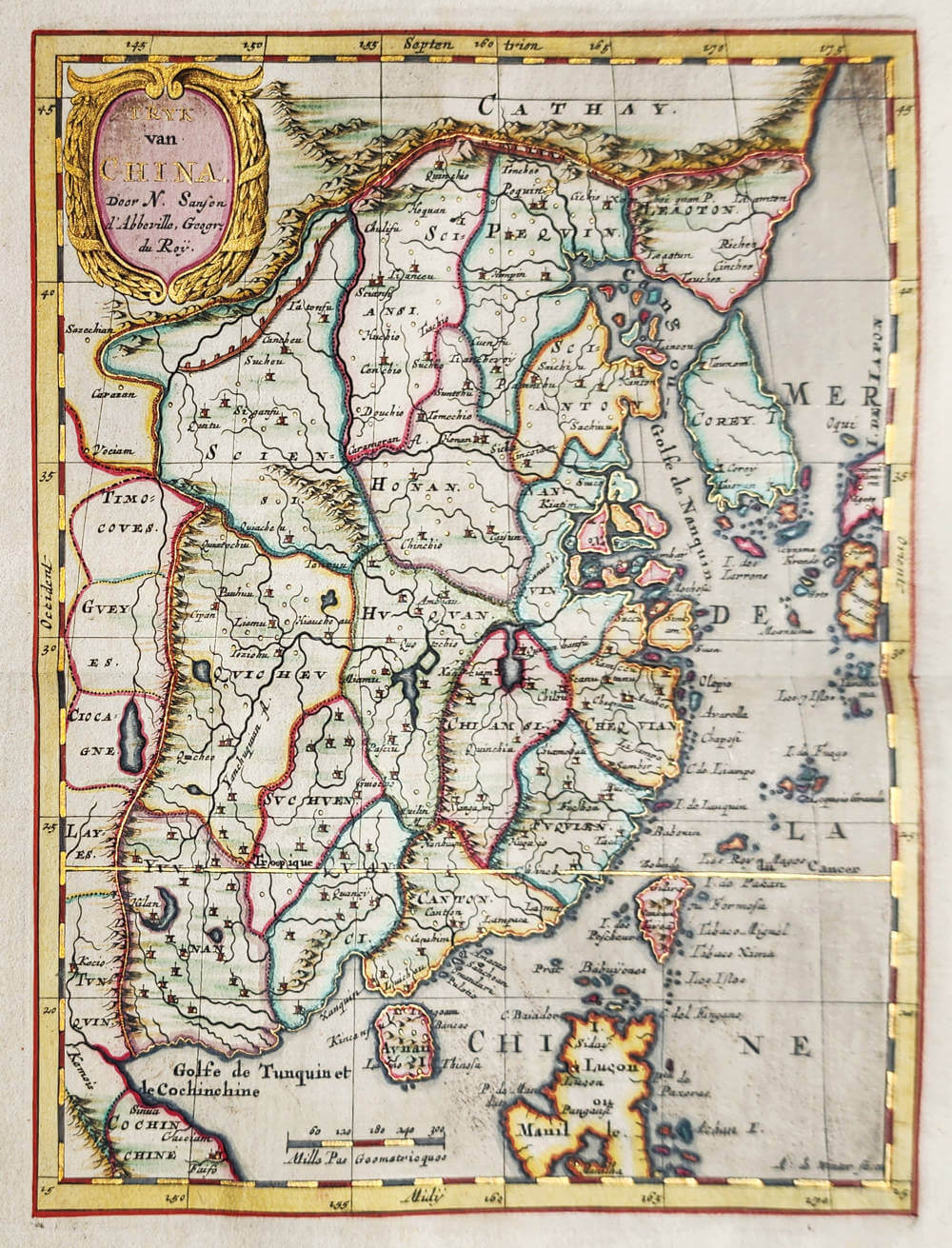
't Ryk van China.
The Empire of China.
A very attractive mid-17th century quarto-sized map of China and all of its provinces. This map of China also includes Korea shown as an island, here called Corey, and Japan, as well as part of the Philippines. It includes the Great Wall of China.
Engraved and signed by Antoine de Winter of Amsterdam and compiled and published by the great French Cartographer Nicolas Sanson (1600-1667) in his 'Pocket Atlas of Asia' published in 1652. This example is from a Dutch edition of the atlas published between 1653-60.
Condition
Here in superb contemporary outline color lavishly heightened in gold to highlight the borders of countries, the major settlements, the tropics of cancer, arctic circle) , the title and its ornamented cartouche, the scale bar as well as the longitude and latitude markings around the map. Strong and even imprint of the copperplate. Very wide margins. A stunning collector's prize.
The gold highlighting was a rare feature of expensive deluxe versions of atlases that were produced for wealthy and important customers or royals and reached its zenith in Blaeu's lavish 'Atlas Maior' published in 1662.
The colouring and illumination of this map and the atlas it was in was most likely done by Dirk Janszoon van Santen, the most famous master illuminator of the Dutch golden age.
Nicolas Sanson (1600-1667)
Nicolas Sanson was the foremost French mapmaker of the period.
Sanson was born in Abbeville where as a young man he studied history, particularly of the ancient world, and it is said that he turned to cartography only as a means of illustrating his historical work. For this purpose he prepared a number of beautifully drawn maps, one of which, after his move to Paris, came to the attention of Louis XIII. In due course the King appointed him ‘Géographe Ordinaire du Roi', one of his duties being to tutor the King in geography.
In the preparation of his major atlas, Cartes Générales de Toutes les Parties du Monde, Sanson employed a number of engravers, one of whom, M. Tavernier, engraved important maps showing the Post Roads and River and Waterway system of France (1632–34) and a map of the British Isles (1640). In all, Sanson produced about 300 maps of which two of North America were particularly influential: Amerique Septentrionale (1650) and Le Canada ou Nouvelle France (1656), the first map to show all the Great Lakes. After Sanson's death the business was carried on by his two surviving sons and grandson, in partnership with A. H. Jaillot.
It is generally accepted that the great age of French cartography originated with the work of Nicolas Sanson but credit must go also to A. H. Jaillot and Pierre Duval for re-engraving his maps, many still unprinted at his death, and re-publishing them in face of strong competition from the Dutch, who continued to dominate the market until the end of the century.
Related Categories
Related Items


