Leen Helmink Antique Maps
Old books, maps and prints by Herman Moll
Herman Moll (1654-1732)
Herman Moll, born around 1654 in Bremen, Germany, was a notable cartographer during the late 17th and early 18th centuries. His work played a role in mapping the world during a time when exploration and scientific discovery were on the rise.
Early Life and Beginnings
Little is known about Moll's early years, but it is known that he moved to London in the late 1670s or 1680s. This move was crucial as London was becoming a hub for geographical and scientific knowledge. Moll began his career as an engraver, initially for other cartographers, which gave him the necessary skills and connections to establish himself in the field.
Cartographic Career
Moll started creating his own maps at the beginning of the 18th century. His "Thesaurus Geographicus" of 1695 was one of his initial projects, followed by "A Set of Fifty New and Correct Maps of England and Wales" in 1708. These works showed a focus on detail and included political and historical context.
Moll's maps were characterized by their decorative elements like borders and cartouches, with smaller inset maps for detailed views of significant areas. His maps of the Americas, particularly those of North America, were influential as they incorporated the latest geographical discoveries and were updated frequently to reflect new findings.
Contributions and Notable Works
One of Moll's most famous works was "The World Described," published in 1715, which was essentially an atlas offering a comprehensive view of the known world at the time. This atlas was regularly updated with new editions throughout his life, showing his commitment to accuracy and relevance. Another significant publication was his "Atlas Minor," which aimed at a broader audience by providing concise, yet detailed, maps.
Moll's map of the British Isles, "A New and Exact Map of the Dominions of the King of Great Britain," from 1715, is particularly noteworthy. It not only depicted geographical features but also included postal routes, which was innovative for its time, reflecting the growing postal service and the need for more practical applications of cartography.
The Large Map of the East Indies
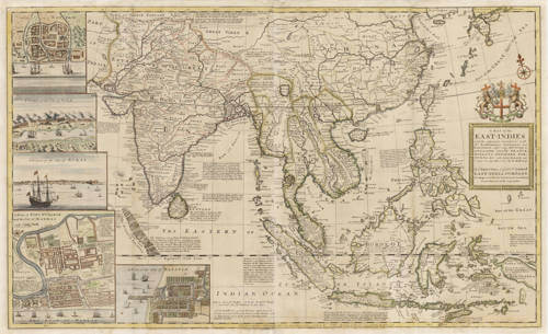
Moll produced "A Map of the East-Indies and the Adjacent Countries" around 1715, dedicated to the directors of the British East India Company. This map depicted the extent of European influence in the East Indies, with insets of trade hubs like Bantam and Madras, reflecting the commercial interests of the period.
Later Years
Moll's later years saw him continuing his work, although his health might have declined, as suggested by less frequent publications. He died in 1732 in London, leaving behind a body of work that influenced cartography for decades. His maps were used in schools, by explorers, and in government offices, aiding in both education and the practical administration of territories.
