Leen Helmink Antique Maps
Antique map of Scandinavia by Ortelius


Stock number: 18672
Zoom ImageTitle
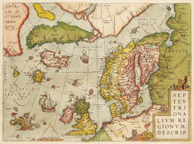
Septentrionalium Regionum Descrip.
First Published
Antwerp, 1570
Size
36.0 x 48.7 cms
Technique
Condition
mint
Price
This Item is Sold
Description
Summary
Myths and legends: Ortelius' rendering of Scandinavia and the North Atlantic based on Olaus Magnus 1539 map, Zeno's 1558 map and on Mercator's 1569 wall map of the world.
Ortelius includes much of the spectacular "Zeno" map of the North Atlantic after the map in a 1558 travel book about a (false?) voyage in 1380 to these areas by Nicolò and Antonio Zeno. That map introduces many new fictitious islands in great detail like "Frisland" (with 32 places and capes named!), "Deogeo", "Estotiland", "Estland", and the monastery of "S. Tomas" in Greenland. Many of these lovely products of imagination remained on maps for centuries, mainly because Gerard Mercator accepted it as authentic and adopted much of it in his famous large 1569 world map and his 1595 map of the North Pole. Ortelius in turn used the map as a prototype for his map of the North Atlantic. Frobisher and Davis accepted the map for their explorations in the 1570's and 1580's, respectively.
Scandinavia in Old Maps and Prints
In his preface Ortelius only mentions Olaus Magnus as a cartographical reference. When both maps are compared, there appear to be some similarities (the configuration of Scandinavia and of Finland, especially, and some topographical details, like the 'Lacus Albus', for instance. This conformity, however, is of a rather superficial nature. Ortelius undoubtedly also used other sources to prepare his maps.
(Mingroot - van Ermen).
Printed Maps of Scandinavia and the Arctic, 1482-1601
Ortelius' map of Scandinavia appears from the first edition onward. Among the sources in the 'Catalogus' for the Scandinavia map are Ziegler, Olaus Magnus, and Zeno.
Turning to the map itself, one can see the influence of both Magnus and Zeno, particularly in some of the mythical islands in the north Atlantic (e.g. Frisland). However, Estotiland is clearly on the mainland of America and may be associated with Labrador. In that case, the island of Drogeo may represent Newfoundland. Although the imaginary isle of Icaria remains, Estland has been removed.
The plate of the SEP/TEN/TRI/ONA/LIVM RE/GIONVM/ DESCRIP. map was altered during the long life of the atlas as well. However, most of the changes are fairly modest. The only substantive modification occurred with the 1592 Latin edition, when eight place names were added to the polar island north of the Scandinavian peninsula.
(Ginsberg).
The Mapping of North America
A number of mythical islands appear in the North Atlantic; Drogeo, however, is believed to represent Newfoundland. The mainland of America is depicted in the north-west with the placename Estotiland.
(Burden).
Maps in Ortelius' Theatrum Orbis Terrarum
This is one of the most remarkable maps in the 'THEATRUM' in that it displays a mixture of exact observation and fantasy. Although Scandinavia is somewhat boldly drawn, it represents, nevertheless, the best available knowledge of the region taken from the famous map by Olaus Magnus (1539). In Norway we find an enormously enlarged Trondheim fiord. In Finland, the Gulf of Finland is erroneous and large lakes are shown in the North. Sweden is too thick and has a strange lake in Lapland. To the fantastic elements belong the 'Northland' in the Arctic Ocean with the remarkable annotation: 'Pigmei hic habitant', a 'Groclandt' (as well as a Greenland) with the cities of 'Alba' and 'St. Thomas' on the 75th parallel, and the mythical islands of 'Frisland', 'St. Brandain', 'Drogeo' and 'Podalia'.
The island of Frisland in particular, with its many cities, causes surprise. It would appear that learned cartographers such as Mercator and Ortelius accepted this island on the authority of Nicolò Zeno, the Venetian, which was published in 1558 by Francesco Marcolini. This map accompanied an account, reconstructed by Nicolò Zeno, of the voyages of exploration in the Northern Atlantic said to have been undertaken by his ancestors. The genuineness of Zeno's account is highly suspect. What is remarkable, however, is that the island of Frisland continued to be shown on maps until the middle of the seventeenth century.
(Koeman).
Antique Maps - A Collector's Guide
An interesting map of the Northern Regions showing many non-existent islands including Brasil and St Brendan's Island and a note in the Arctic stating that 'Pigmys live here'.
Where better to start than by looking at the mythical island of Hy Brazil which appeared out in the Atlantic to the west of Ireland in charts as early as 1325, in the famous Catalan Atlas dated 1375 and, subsequently, on numerous maps for the next 200 years, including Waldseemüller's map of the British Isles issued at Strassburg in 1513 and its later editions. It was also shown on Toscanelli's chart dated about 1457 which was said to have been used by Columbus on his first voyage. Early Celtic legends say that the island only appeared at sunset in the mists of the Atlantic and they called it 'the blessed stormless isle, where all men are good and all the women pure and where God retreats for a recreation from the rest of us'.
To add to our confusion these early charts depicted not only Brazil off the coast of Ireland but also St Brendan's Island far out in the ocean half way to Zipangu (Japan). We can imagine the Irish monk, St Brendan, setting sail sometime in the sixth century on a seven-year voyage in search of this paradise and arriving, according to one version, in the Fortunate Isles (the Canaries), then the limit of the known world. According to other interpretations he reached not only the Hebrides and the Faroes but even America. It is hard to believe that as late as the eighteenth century seamen were still seeking these islands, and so often had Brazil been 'sighted' that geographers were reluctant to abandon the possibility of its existence; in fact it was not finally removed from British Admiralty charts until the 1870s. The Celts were not alone in their belief in the existence of an earthly paradise in the Western Ocean; the Greeks too, among others, imagined these 'Isles of the Blest' beyond the Pillars of Hercules which legend claimed were 'peopled not by the dead but by mortals on whom the Gods had conferred immortality' and where there was perpetual summer and abundance.
(Moreland & Bannister).
Early Sea Charts
The part of the Mercator world chart, depicted here in eighteen sheets, shows the northern part of the Atlantic, the northernmost parts of Europe, America, Greenland, and part of the polar area. This chart is interesting because it disseminated a number of cartographical mistakes in the depiction of the area northwest of Ireland. The source of these mistakes is the imagined itinerary of a voyage supposedly made by the Venetian brothers Nicolo and Antonio Zeno at the end of the fourteenth century.
Shortly before Mercator had finished his chart, this work together with a map of this area, dated 1380, was published in Venice. On the basis of this evidence, the Venetians claimed the first discovery of the mainland of America. Unfortunately Mercator believed the story and offered the “Zenomap” as his authority. Mercator incorporated its information into this part of his chart. Thus appeared the nonexistent island of Friesland, south of Thule (Iceland), just like the islands of Brazil, and S. Brandain, referring to the Irish monk who sailed the waters west of Ireland. For the first time the name Estoti-land appears on the coast of America.
(Putman on this area on Mercator's 1569 wall map of the world).
Collecting Old Maps
In this map, the North Atlantic is littered with mythical islands, some traceable to the Zeno legend. In 1558 Marcolino published a book by Nicolò Zeno in which the "discovery" of several of these islands was noted. The book was allegedly a compilation of northern voyages by Zeno's ancestor made over a hundred years earlier. Zeno himself edited this map for Ruscelli's geography. The information on this map was used later by Ortelius in his map of the northern regions of the Atlantic.
Among the mythical islands shown, Frisland in particular had a long cartographic life. Many later maps continued to show it, some with exquisite detail and even locating its capitol city.
This map shows some famous cartographical misconceptions. Along with maps showing California as an island, the Prester John maps of Africa, the wonderful Schlaraffenland and perhaps the Kircher map of Atlantis, this map should be part of the backbone of an collection of maps of mythical geography.
(Manasek on the Ruscelli Zeno map).
Abraham Ortelius (1527-1598)
Abraham Ortelius is the most famous and most collected of all early cartographers. In 1570 he published the first comprehensive collection of maps of all parts of the world, the Theatrum Orbis Terrarum ("Theatre of the World"), the first modern atlas as we know it.
"Abraham Ortel, better known as Ortelius, was born in Antwerp and after studying Greek, Latin and mathematics set up business there with his sister, as a book dealer and ‘painter of maps'. Traveling widely, especially to the great book fairs, his business prospered and he established contacts with the literati in many lands. On one such visit to England, possibly seeking temporary refuge from religious persecution, he met William Camden whom he is said to have encouraged in the production of the Britannia.
A turning point in his career was reached in 1564 with the publication of a World Map in eight sheets of which only one copy is known: other individual maps followed and then – at the suggestion of a friend - he gathered together a collection of maps from contacts among European cartographers and had them engraved in uniform size and issued in 1570 as the Theatrum Orbis Terrarum (Atlas of the Whole World). Although Lafreri and others in Italy had published collections of ‘modern' maps in book form in earlier years, the Theatrum was the first uniformly sized, systematic collection of maps and hence can be called the first atlas, although that term itself was not used until twenty years later by Mercator.
The Theatrum, with most of its maps elegantly engraved by Frans Hogenberg, was an instant success and appeared in numerous editions in different languages including addenda issued from time to time incorporating the latest contemporary knowledge and discoveries. The final edition appeared in 1612. Unlike many of his contemporaries Ortelius noted his sources of information and in the first edition acknowledgement was made to eighty-seven different cartographers.
Apart from the modern maps in his major atlas, Ortelius himself compiled a series of historical maps known as the Parergon Theatri which appeared from 1579 onwards, sometimes as a separate publication and sometimes incorporated in the Theatrum."
(Moreland and Bannister)
"The maker of the ‘first atlas', the Theatrum Orbis Terrarum (1570), started his career as a colorist of maps. Later, he became a seller of books, prints and maps. His scientific and collecting interests developed in harmony with those of a merchant. He was first and foremost a historian. Geography for him was the ‘eye of history', which may explain why, in addition to coins and historical objects, he also collected maps. On the basis of his extensive travels through Europe and with the help of his international circle of friends, Ortelius was able to build a collection of the most up-to-date maps available.
The unique position held by Ortelius's Theatrum in the history of cartography is to be attributed primarily to its qualification as ‘the world's first regularly produced atlas.' Its great commercial success enabled it to make a great contribution to ‘geographical culture' throughout Europe at the end of the sixteenth century. Shape and contents set the standard for later atlases, when the centre of the map trade moved from Antwerp to Amsterdam. The characteristic feature of the Theatrum is that it consists of two elements, text and maps. Another important aspect is that it was the first undertaking of its kind to reduce the best available maps to a uniform format. To that end, maps of various formats and styles had to be generalized just like the modern atlas publisher of today would do. In selecting maps for his compilation, Ortelius was guided by his critical spirit and his encyclopaedic knowledge of maps. But Ortelius did more than the present atlas makers: he mentioned the names of the authors of the original maps and added the names of many other cartographers and geographers to his list. This ‘catalogus auctorum tabularum geographicum,' printed in the Theatrum, is one of the major peculiarities of the atlas. Ortelius and his successors kept his list of map authors up-to-date. In the first edition of 1570 the list included 87 names. In the posthumous edition of 1603, it contained 183 names.
Abraham Ortelius himself drew all his maps in manuscript before passing them to the engravers. In the preface to the Theatrum he stated that all the plates were engraved by Frans Hogenberg, who probably was assisted by Ambrosius and Ferdinand Arsenius (= Aertsen). The first edition of the Theatrum is dated 20 May 1570 and includes 53 maps.
The Theatrum was printed at Ortelius's expense first by Gielis Coppens van Diest, an Antwerp printer who had experience with printing cosmographical works. From 1539 onwards, Van Diest had printed various editions of Apianus's Cosmographia, edited by Gemma Frisius, and in 1552 he printed Honterus's Rudimentorum Cosmograhicorum... Libri IIII. Gielis Coppens van Diest was succeeded as printer of the Theatrum in 1573 by his son Anthonis, who in turn was followed by Gillis van den Rade, who printed the 1575 edition. From 1579 onwards Christoffel Plantin printed the Theatrum, still at Ortelius's own expense. Plantin and later his successors continued printing the work until Ortelius's heirs sold the copperplates and the publication rights in 1601 to Jan Baptist Vrients, who added some new maps. After 1612, the year of Vrients's death, the copperplates passed to the Moretus brothers, the successors of Christoffel Plantin.
The editions of the Theatrum may be subdivided into five groups on the basis of the number of maps. The first group contains 53 maps, 18 maps were added. The second group has 70 maps (one of the 18 new maps replaced a previous one). In 1579 another expansion was issued with 23 maps. Some maps replaced older ones, so as of that date the Theatrum contained 112. In 1590 a fourth addition followed with 22 maps. The editions then had 134 maps. A final, fifth expansion with 17 maps followed in 1595, bringing the total to 151."
(Peter van der Krogt, Atlantes Neerlandici New Edition, Volume III)
Gerard Mercator (Kremer) 1512-1594
Arnold Mercator (son) 1537–1587
Rumold Mercator (son) c. 1545– c. 1599
Bartholomeus Mercator (son) fl. 1540-1563
Gerard Mercator (grandson) c. 1563-1656
Joannes Mercator (grandson) c. 1562-1595
Michael Mercator (grandson) c. 1567–1600
For nearly sixty years, during the most important and exciting period in the story of modern map making, Gerard Mercator was the supreme cartographer, his name, second only to Ptolemy, synonymous with the form of map projection still in use today. Although not the inventor of this type of projection he was the first to apply it to navigational charts in such a form that compass bearings could be plotted on charts in straight lines, thereby providing seamen with a solution to an age-old problem of navigation at sea.
His influence transformed land surveying and his researches and calculations led him to break away from Ptolemy conception of the size and outline of the Continents, Drastically reducing the longitudinal length of Europe and Asia and altering the shape of the Old World as visualized in the early sixteenth century.
Mercator was born in Rupelmonde in Flanders and studied in Louvain under Gemma Frisius, Dutch writer, astronomer and mathematician. He established himself there as a cartographer and instrument and globe maker, and when he was twenty-five drew and engraved his first map (of Palestine) and went on to produce a map of Flanders (1540) supervising the surveying and completing the drafting and engraving himself.
The excellence of his work brought him the patronage of Charles V for whom he constructed a globe, but in spite of his favour with the Emperor he was caught up in the persecution of Lutheran protestants and charged with heresy, fortunately without serious consequences. No doubt the fear of further persecution influenced his move in 15 s 2 to Duisburg, where he continued the production of maps, globes and instruments culminating in large-scale maps Europe (1954), the British Isles (1564) and the famous World Map on 18 sheets drawn to his new projection (1969). All these early maps are exceedingly rare, some being known by only one copy.
In later life he devoted himself to his edition of the maps in Ptolemy's Geographia, reproduced in his own engraving as nearly as possible in their original form, and to the preparation of his 3-volume collection of maps to which, for the first time, the word 'Atlas' was applied. The word was chosen, he wrote, 'to honour the Titan, Atlas, King of Mauritania, a learned philosopher, mathematician and astronomer'. The first two parts of the Atlas were published in 1583 and 1589 and the third, with the first two making a complete edition, in 1595, the year after Mercator's death.
Mercator's sons and grandsons, named above, were all cartographers and made their contributions in various ways to the great atlas. Rumold, in particular, was responsible for the complete edition in 1595. After a second complete edition in 1602, the map plates were bought in 1604 by Jodocus Hondius who, with his sons, Jodocus II and Henricus, published enlarged editions which dominated the map market for the following twenty to thirty years.
(Moreland & Bannister).


