Leen Helmink Antique Maps
Antique map of Western North America by de Jode
Stock number: 18902
Zoom ImageCartographer(s)
Cornelis de Jode (biography)
Title
Quivirae Regnu, cum alijs versus Borea.
First Published
Antwerp, 1593
This Edition
1593 first and only edition
Size
35.0 x 24.5 cms
Technique
Condition
some color offsetting, excellent
Price
$ 11,000.00
(Convert price to other currencies)
Description
Cornelis de Jode: Quivirae Regnu, cum alijs versus Borea.
Antwerp, 1593. Copper engraving, 35.0 x 24.5 cms. First and only edition, only known state. Burden 82; Van der Krogt 3, 9190:32; Wagner, Cartography of the Northwest Coast.
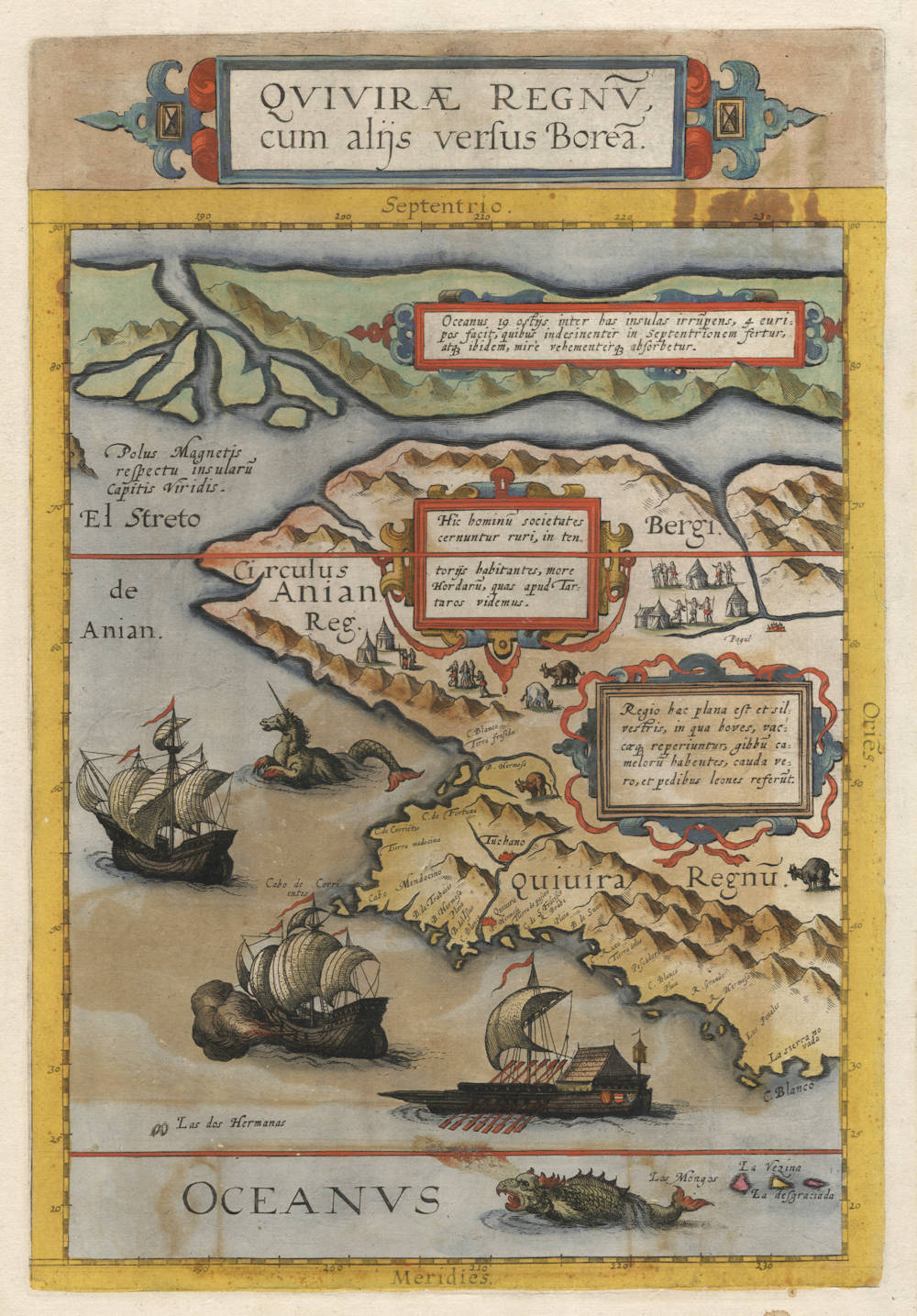
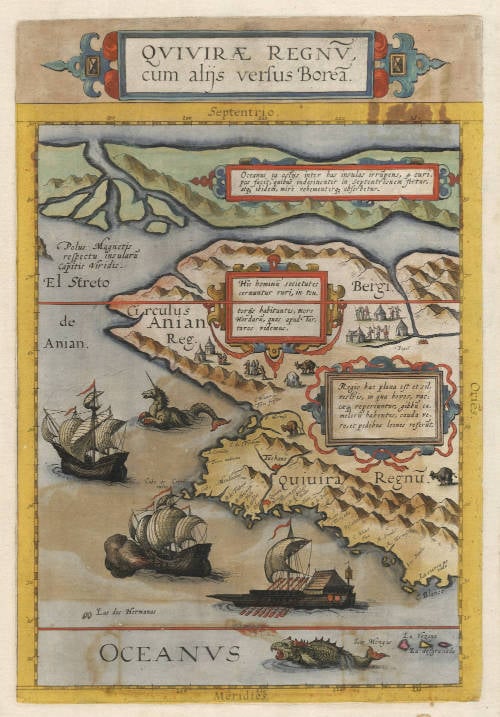
Cornelis de Jode's landmark map of the west coast of North America, the first printed map devoted to the western and northwestern coasts of the continent. It covers the Pacific seaboard from about latitude 30°N to the North Pole itself, which forms the top border of the map, taking in all of today's western United States, western Canada and Alaska. The Tropic of Cancer runs near the bottom of the map and the Arctic Circle about two-thirds of the way up.
The map appeared in de Jode's Speculum Orbis Terrae of 1593, the enlarged edition of the atlas that Gerard de Jode had first issued in 1578 in competition with Ortelius' Theatrum, completed and published posthumously by his son Cornelis. Cartographically it is largely derived from the great eighteen-sheet world map of Petrus Plancius of 1592, and it couples perfectly with de Jode's Americae Pars Borealis of the same year to complete the coverage of North America. Only part of the coastline records first-hand knowledge; the interior is a fascinating amalgam of the reports of the Spanish Pacific explorers, Marco Polo's account of his travels in Asia, and the geographical beliefs and legends of the age.
The map takes its name from Quivira, the fabled golden kingdom that Francisco Vázquez de Coronado pursued across the Southwest and onto the Great Plains in 1540-42. Coronado never found the promised riches, but the name Quivira remained fixed on maps of western North America for well over a century, migrating from the plains to the Pacific coast, as here.
Along the coast appear the landmarks of the early Spanish voyages, including C. Mendocino, named in honor of the viceroy Mendoza. The westernmost point of the California coast, this was the landfall that the annual Manila galleons aimed for at the end of their long eastbound crossing after Urdaneta's discovery of the transpacific return route in 1565: the first land raised on the run east along the westerlies, before the turn south along the coast for Acapulco. Two degrees below it, at 39°N, appears C. de S. Francisco, one of the most puzzling toponyms of early California cartography. The name predates Cermeño's 1595 christening of Drake's Bay as "Bahía de San Francisco" (the naming from which the later bay and city ultimately took their name) and thus cannot derive from it. Wagner, in his authoritative survey of the coast's nomenclature, found its origin unknown, noting that it probably first appeared on the Plancius maps of 1589 or 1590 and that the Plancius nomenclature on this stretch of then-unexplored coast is apparently largely invented. The coincidence that the cape sits at almost exactly the latitude of Francis Drake's 1579 anchorage at Point Reyes, just south of Mendocino, has not escaped notice, but the connection remains unproven. Inland the Sierra Nevada ("snowy mountains") is noted, first named in 1542 during the Cabrillo voyage as one of the few interior features clearly visible from the explorers' ships.
America is separated from Asia by the as yet undiscovered but correctly assumed El Streto de Anian (Strait of Anian), a hypothesis first introduced by Giacomo Gastaldi in the 1560s from a misreading of Marco Polo, and subsequently adopted by Mercator and Ortelius. Above it runs the western end of the hoped-for Northwest Passage, an alluring prospect for the English and Dutch navigators of the day.
The Arctic geography derives from Gerard Mercator, who in turn relied on a famous but lost fourteenth-century work known as the Inventio Fortunata, the travel account of an Oxford Franciscan friar who reportedly made several journeys to the far north on behalf of King Edward III. It described the North Pole as a great magnetic rock surrounded by four large islands, between which the ocean rushed inward through many channels to be swallowed into an enormous whirlpool at the Pole. The Inventio was already lost in Mercator's day, but he knew it through a summary by the Brabant traveller Jacob Cnoyen, as he explained in his 1577 letter to the English polymath John Dee; the Cnoyen summary itself disappeared soon after. Part of Mercator's four polar islands appears along the top of the map, with a legend describing the indrawing sea. In the upper left is a rock representing the Magnetic Pole, with the legend Polus Magnetis respectu insularu Capitis Viridis, an early indication of magnetic declination. The magnetic pole is positioned "with respect to the Cape Verde Islands", where compass variation was known to be zero, so that the magnetic pole had to lie on the same meridian.
Two of the map's Latin cartouches record remarkably early ethnographic and zoological information about the American West. One describes the inhabitants as living in tent encampments "after the manner of the Hordes we see among the Tartars", and the tent-dwelling figures engraved beside it are probably the first printed depiction of Native Americans in this part of the continent. The other cartouche describes a flat, wild country where "oxen and cows are found that have the hump of camels, but in tail and feet resemble lions": one of the earliest cartographic descriptions of the American bison, echoing the reports of the Coronado expedition.
The engraving is beautifully adorned in the best Antwerp manner. Two sea monsters swim in the Pacific alongside a galley and two caravels copied after the celebrated ship designs of Pieter Bruegel the Elder, one vessel firing a broadside, another under full sail.
The Speculum was a commercial failure against the entrenched Theatrum of Ortelius. When Cornelis de Jode died young in 1600, the copperplates passed to Jan Baptiste Vrients, who had just acquired the Ortelius plates as well, and who evidently bought them simply to suppress any further publication. Issued in a single edition and a single state, the map is consequently very rare.
Text legends, transcribed and translated
Quivirae Regnu, cum alijs versus Borea.
"The Kingdom of Quivira, with other regions toward the North."
1. (central cartouche, on the inhabitants)
Hîc hominū societates cernuntur ruri, in tentorijs habitantes, more Hordarū, quas apud Tartaros videmus.
"Here communities of people are seen in the countryside, dwelling in tents, after the manner of the Hordes which we see among the Tartars."
2. (eastern cartouche, on the bison)
Regio hæc plana est et silvestris, in qua boves, vaccæq[ue] reperiuntur, gibbū camelorū habentes, cauda vero, et pedibus leones referūt.
"This region is flat and wild, in which oxen and cows are found that have the hump of camels, but in tail and feet they resemble lions."
3. (northern cartouche, on the polar whirlpool)
Oceanus 19. ostijs inter has insulas irrūpens, 4 euripos facit, quibus indesinenter in Septentrionem fertur, atq[ue] ibidem, mire vehementerq[ue] absorbetur.
"The Ocean, bursting in through 19 mouths between these islands, forms four channels, by which it is carried unceasingly toward the North, and there is swallowed up with marvellous force."
The verso text
QVIVIRAE REGNVM.
HAEC Regio à Ciuitate Quiuira in ea sita nomẽ habet. Pauci sunt qui de hac scribunt quãdoquidem extra communem nauigandi cursum sita est. Huic Regioni à Septẽtrione Regnum Anian est, Terra inculta ac propter frigus ferè inhabitata, nisi quod in quibusdam locis incolæ more Tartarorum per Hordas in tentorijs degant. Ab hac Regione in Asiam siue Indiam Orientalem nõ admodùm longum esse maris tractum pro vero habetur: Immo quod maius est à nobis in Indiam & econtra per hanc viam aditum patere adfirmat Cornelius Nepos, vbi dicit per hãc viam quosdam Indianos tempestate fuisse abreptos, atq[ue] in Sueuorum & Germaniæ littus fuisse abiectos, donoq[ue] datos Q. Metello Coleri [recte Celeri] Galliæ proconsuli. Versus Orientem hæc Regiò plana est, ac vaccas alit gibbos habentes instar Camelorum, caneas verò lenum [recte caudas verò leonum] similes, ibidemque ouium, Boum, ac aliorum animalium ingens copia, adeo hîc Regio fertilis est. Quidam hanc Regionem vsque ad polum arcticum extendi putant, alij eam 76. longitudinis graduum desinere putant, verum hac de re quid sit adhuc ignotum est.
"THE KINGDOM OF QUIVIRA.
This region takes its name from the city of Quivira situated within it. Few authors write about it, since it lies outside the common course of navigation. To the north of this region lies the Kingdom of Anian, a land uncultivated and, on account of the cold, almost uninhabited, except that in certain places the inhabitants live in tents in Hordes, after the manner of the Tartars. From this region to Asia, or the East Indies, the stretch of sea is held for certain to be not very long: indeed, what is more, Cornelius Nepos affirms that by this route a passage lies open from us to India and back again, where he relates that certain Indians were carried off by a storm along this way and cast ashore on the coast of the Suevi and of Germany, and were presented as a gift to Quintus Metellus Celer, proconsul of Gaul. Toward the east this region is flat, and it sustains cows that have humps like those of camels, but tails like those of lions; and there is likewise a vast abundance of sheep, oxen and other animals, so fertile is this region. Some believe this region extends all the way to the Arctic Pole; others hold that it ends at the 76th degree of longitude [evidently latitude is meant]; but what the truth of the matter may be is as yet unknown."
Note: the anecdote of the "Indians" shipwrecked on the German coast and presented to Quintus Metellus Celer comes from Pomponius Mela (De Chorographia III.5), who cites Cornelius Nepos as his source. It was one of the most frequently invoked classical "proofs" in the sixteenth century that a navigable northern passage connected Europe and Asia, and its inclusion here shows de Jode marshalling ancient authority in support of the Strait of Anian and the Northwest Passage shown on the map.
Textual note: the verso was carelessly set. The type reads caneas verò lenum similes, a compositor's corruption of caudas verò leonum similes ("but tails like those of lions"). The intended reading is guaranteed by the map cartouche itself (cauda vero et pedibus leones referunt) and by the Gómara-derived bison descriptions from which it descends. Likewise the type reads Q. Metello Coleri for Celeri (Quintus Metellus Celer).
Gerard de Jode (c.1509-1591)
Cornelis de Jode (son) (1568-1600)
Gerard de Jode originally issued his atlas in 1578 to compete with Ortelius' atlas with little success. In 1593, two years after his death, Gerard's son Cornelius re-issued the atlas. The success of the atlas was very limited due to heavy competition with Ortelius, who also seems to have bought many copies of de Jode's atlas to take them off the market. Because of this, both editions of the de Jode atlas are exceptionally rare.
"Gerard de Jode, born in Nijmegen, was a cartographer, engraver, printer and publisher in Antwerp, issueing maps from 1555 more or less in the same period as Ortelius. He was never able to offer very serious competition to his more businesslike rival although, ironically, he published Ortelius's famous 8-sheet World Map in 1564. His major atlas, now extremely rare, could not be published until 1578, eight years after the 'Theatrum', Ortelius having obtained a monopoly for that period.
The enlarged re-issue by his son in 1593 is more frequently found. On the death of Cornelis, the copper plates passed to J.B. Vrients (who bought the Ortelius plates about the same time) and apparently no further issue of the atlas was published."
(Moreland & Bannister).
"After the death of Cornelis in 1600, the copper-plates came into the hands of Jan Baptiste Vrients, then the publisher of Ortelius' Theatrum. Apparantly Vrients must have bought them to prevent any further publication of the Speculum."
(Koeman)