Leen Helmink Antique Maps
East India Company chart by John William Norie
Three copies known
from copperplates originally produced by Penelope Steel
The item below has been sold, but if you enter your email address we will notify you in case we have another example that is not yet listed or as soon as we receive another example.

Stock number: 19663
Zoom ImageTitle
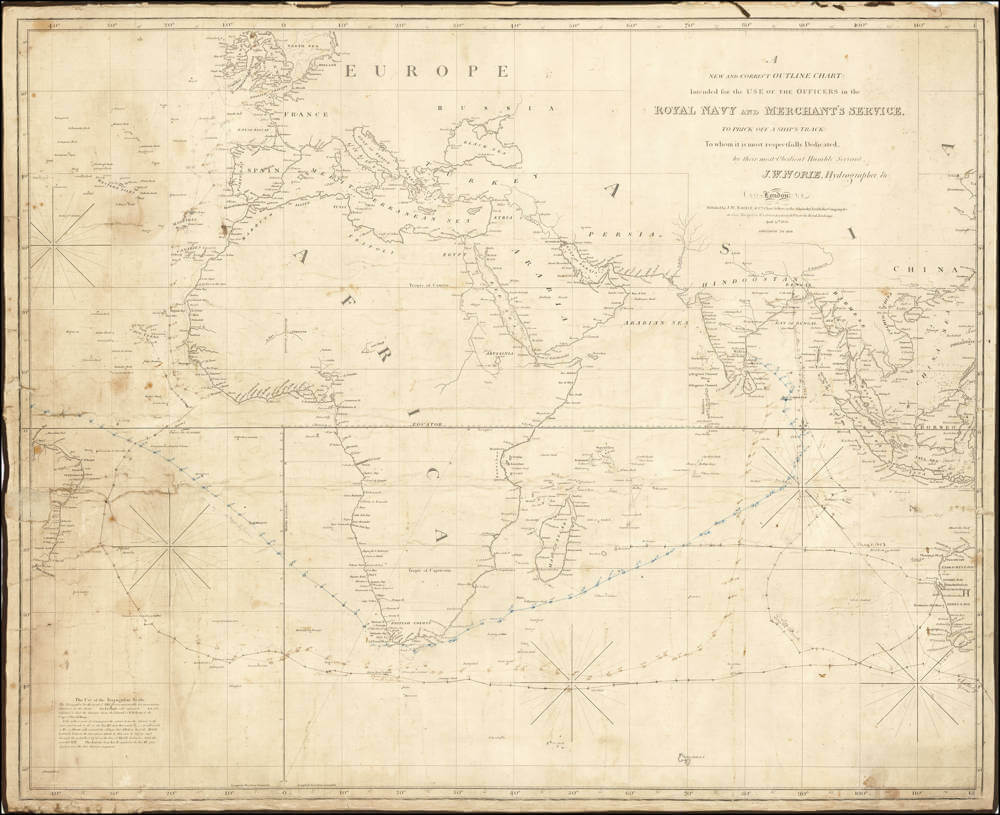
A New and Correct Outline Chart: Intended for the Use of the Officers in the Royal Navy and Merchant's Service To Prick Off A Ship's Track: to whom it is most respectfully Dedicated, by their most Obedient Humble Servant, J.W.NORIE, Hydrographer, &c. London, April 25th 1833. Additions to 1844.
First Published
London, 1809
This Edition
London, 1833, with additions to 1844
Size
69.5 x 82.5 cms
Technique
Condition
very good
Price
This Item is Sold
Description
Early navigation chart of the waters between Europe and British India, Australia and Southeast Asia, originally produced in 1809 by Penelope Steel , illustrious female cartographer for the English East India Company.
This example in the later state of 1833 (with "additions to 1844") by John William Norie, who in 1819 acquired the stock of Steel's Company.
Norie has changed Penelope Steel's original dedication of the sea chart from
Intended for the use of the officers in the
Honorable East India Company's Service
to
Intended for the use of the officers in the
Royal Navy and Merchant's Service
The reason being that the English East India Company had a monopoly on trading with India until 1813. In that year, the British Parliament passed the Charter Act of 1813, which ended the company's exclusive trading rights in India, although it retained control over the administration of British territories in India.
The chart has several pricked off and dated ship's tracks from Europe to India, Australia and back to Europe and the Caribbean, with annotated dates between 1846 and 1853. One track records a ship that anchors at Shark's Bay, and another one going from Calcutta to Port Phillip around Cape Leeuwin. Winds and water currents are annotated. On the back are captain's names and ship's names.
A track in blue pencil, departing Madras on Nov 21st, 1846, rounding the Cape of Good Hope on Jan 1st 1847, porting at St Helena on Jan 12th-13, and entering the Caribbean by the end of January.
The chart covers the route from Europe to the East Indies and is thus far known only in examples with the imprint of J.W. Norie indicating a first edition of 1833 and known in only three examples of 1837 (NLA MAP RM 3122), 1849 (NLA MAP RM 4742) and 1852 (NLA MAP RM 1391).
Comparison between the examples of this chart makes it clear that the chart could be bought in different configurations, with or without the Americas and/or the Far East, so it was tailored to the needs of the buyers.
The chart here proves that Norie acquired this copperplate from the Steel company and extensively updated it, at least in the thus far known states of 1837 and 1852. While the Penelope issue only has a handful of toponyms for the fifth continent, including the Dutch geographical names for Western Australia, including "NEW HOLLAND", the Norie states of 1837 and 1852 on the other hand have introduced the name "AUSTRALIA" and hundreds of English toponyms and discoveries all over the continent. Similar detail has been added all over the Far East and the Indian Ocean.
Interestingly, Norie at the time also publishes a chart of the same areas but printed from an updated copperplate first published by William Heather in 1791, not to be confused with this chart.
Rarity
Despite being printed and used in considerable quantities at the time, East India Company charts from the early 1800s in general are excruciatingly rare. We have not been able to find any reference to this 1844 Norie state of the chart of Penelope Steel, neither in the literature, in the major collections, or in the auction and dealer records. Only three examples of the Norie chart are known, in different states, all three in the National Library of Australia:
- 1837 (NLA MAP RM 3122)
- 1849 (NLA MAP RM 4742)
- 1852 (NLA MAP RM 1391).
Only one single copy is known of the original Penelope Steel 1809 issue of the chart, in the State Library of Western Australia:
- 1809 (SLWA CALL NO MAP MAPR0000492)
No other copies of this seminal English East India Company chart are known. No copy in the National Maritime Museum in Greenwich.
Significance
When comparing the chart to the other three known examples by Norie, and the first state by Penelope Steel, it is obvious that John William Norie was keen to update his charts according to the latest information.
For instance, for Western Australia, the Steel 1809 state has mostly Dutch toponyms, with a few early English toponyms like Cape Chatham (named by George Vancouver in 1791), Rosemary Island (named by Dampier in 1699), and Sandy Point near Dirk Hartog's Bay.
On Norie's 1837 issue of the chart, the fifth continent has been labeled as Australia, alongside the old name NEW HOLLAND, and many new toponyms reflect the new Swan River Settlement of 1829, including the town of Perth and many other toponyms. A few old Dutch toponyms remain, like Endracht's Land and [Dirk] Hartog's I[sland], but Penelope Steel's Dirk Hartog's Bay has been renamed Shark's Bay.
The 1844 state by Norie described here is issued only seven years later, but it adds the newly planned town of Australind, the name of which is a combination of Australia and India, which was chosen due to the belief that the area could be used for breeding horses for the British Indian Army. Nothing seems to have come of it, but it shows how keen Norie was to update his charts with the latest information.
Condition description
Used on board for navigation with several plotted ship's courses in blue and black pen and another one or two in pencil. Manuscript notes on the back with Captains and vessel names. Linen backed as issued. Some small wormholes and tatty around the edges, but overall in very good to excellent condition for a used chart of this size.
John William Norie (1772-1843)
John William Norie, born on June 3, 1772, in the bustling maritime district of Wapping, London, would leave an indelible mark on the art and science of navigation during the early 19th century. As the eldest of eight children, Norie was drawn early to the maritime world surrounding him. His aptitude for mathematics and chart-making quickly became evident, setting him on a path that would influence navigators for generations.
Norie's career took flight under the wing of William Heather, a well-established chart and instrument seller who had acquired the firm of Mount and Page. From 1795, Heather operated both a Naval Academy and a Naval Warehouse at 157 Leadenhall Street, a location that would become synonymous with Norie's name. Heather recognized Norie's potential, employing him not only as a chart maker but also as a teacher of navigation. In this vibrant environment, Norie's first publication, "The Description and Use of Hadley's Quadrant," emerged in 1796, marking the beginning of his prolific writing career.
Norie's most significant contribution to navigation was his work, "A New and Complete Epitome of Practical Navigation," first published in 1805. This comprehensive guide became the standard text on the subject, used by mariners worldwide. It was accompanied by "A Complete Set of Nautical Tables" in 1803, both works seeing numerous editions and updates. These publications, known for their clarity and practical application, were so influential that they were referenced in the literary works of authors like Charles Dickens, Jack London, and C. S. Forester, highlighting Norie's impact on cultural as well as practical maritime knowledge.
When William Heather retired in 1812, Norie, with financial backing from George Wilson, purchased the business. This venture marked the beginning of J.W. Norie & Co., later known as the Navigation Warehouse, famous for its sign of the Wooden Midshipman, which captured the imagination of Dickens in "Dombey and Son." Under Norie's management, the company became a leading supplier of nautical charts, instruments, and educational resources, notably for the English East India Company, which relied heavily on his charts for their extensive maritime operations.
In 1819, Norie's business acumen was further demonstrated when he acquired the assets of the Penelope Steel Company, which had fallen into bankruptcy. Originally established by David Steel, Senior, and later managed by his widow Penelope after his death, this company had been a significant producer of nautical charts. The acquisition included the "case fixtures, stock in trade and copper plates," which enriched Norie's repertoire of charts. This move not only expanded his catalog but also helped consolidate his position as a leading hydrographer in London, ensuring that his charts would continue to guide the maritime trade through critical sea routes.
Norie's contributions went beyond publishing; he was instrumental in the design and sale of navigational instruments and in creating detailed, often blue-backed charts that covered nearly all known seas of the world. His maps were not only functional but also works of art, reflecting the aesthetic standards of the time while serving critical practical needs.
In 1840, Norie decided to retire, selling his interest in the company and relocating to Edinburgh. There, he lived until his death on December 24, 1843, at 3 Coates Crescent. His company continued under the name Norie and Wilson until merging in 1903 with James Imray's business to become Imray, Laurie, Norie & Wilson, a name that persists in the maritime industry today.
John William Norie's legacy is one of pioneering navigation in an era when Britain's maritime power was at its zenith. Through his meticulous charts, innovative teaching methods, and comprehensive navigational guides, he not only facilitated safer and more efficient sea travel but also left behind a rich body of work that continues to be referenced in both academic and practical maritime contexts. His acquisition of the Penelope Steel Company was a strategic move that underscored his dedication to ensuring the highest quality navigational resources were available to sailors.
Penelope-Steel (1760?-1820?)
Penelope Steel remains an enigmatic figure in the annals of British cartography, her contributions overshadowed by the male-dominated discourse of her era. Although scant records exist, we can piece together a portrait of a pioneering woman who subtly but significantly influenced the mapping of early 19th-century England. Her life and career illustrate that women contributed to scientific fields in an era that did not readily acknowledge their roles.
Early Life in Jamaica
Penelope Winde was born in Jamaica in the mid-18th century, into a time when the island was a bustling hub of British colonial activity. Little is known about her early life in the Caribbean, but it's believed her family was part of the burgeoning middle class, possibly involved in the trade or plantation economy.
Entry into Cartography
Penelope Winde married a young lawyer called David Steel on 1 May 1786 in London. Although David Steel began married life as a barrister, on the death of his father he took over his business as a nautical publisher and bookseller.
Career and Contributions
Penelope's most notable work came after her husband's death in 1803, when she took over the business. She managed to maintain and even expand the business, producing maps that were known for their detail and appeal.
Her maps were not just technical achievements but also highly skilled, showcasing her proficiency in engraving and her eye for a balanced design.
Challenges and Recognition
Penelope found herself a widow with five small children and remarried to William Mason in 1806.
As a woman in a field dominated by men, Penelope faced numerous challenges. She was often overlooked or had her contributions attributed to male relatives or associates. Nonetheless, she carved a niche for herself, earning respect from a select group of scholars and cartographers. Her work was occasionally mentioned in geographical societies' proceedings, and she corresponded with notable figures like Sir John Barrow of the Admiralty, who acknowledged her work in his writings, although often in passing.
In 1808 several of Steel's charts were chosen by the Admiralty Chart Committee for supply to the fleet. In the early years of the nineteenth century naval officers were stll free to sell their surveys to commercial publishers.
The firm's premises were in Union Row, Little Tower Hill, until Penelope moved the business to 70 Cornhill in 1809. They had a navigation warehouse and a navigation school.
By 1810 the supply of new charts had ceased, and John Purdy, who had apprenticed with David Steel I, left the firm to work with Laurie and Whittle, the Steel’s competitors.
A letter written in 1819 by Thomas Hurd, the Hydrographer of the Navy, to John Barrow, the Second Secretary of the Admiralty, shows that in about 1813 the Admiralty stopped buying charts from the firm.
By 1814, Penelope Steel had entered into a business partnership with Stanley Goddard, a younger man, who would become her third husband, and renamed the firm Steel and Goddard. Goddard had entered an apprenticeship as a printer in 1802 and was probably considerably her junior in age but brought new energy if not experience to the firm.
By June 1819, Goddard and the firm were bankrupt, and J. W. Norie and Company acquired their “case fixtures, stock in trade and copper plates”. Norie and his partner George Wilson spent a large sum on acquiring the prestigious Steel name, which he promoted by adding the words "where may be had all the publications of Steel and Co late of Cornhill" to his imprint for several years.
References:
Susanna Fisher, The Makers of the Blueback Charts, A History of Imray Laurie Norie & Wilson, 2001.
Related Categories
Related Items


