Leen Helmink Antique Maps
Antique map of the World on Mercator projection by Claes Jansz Visscher
The item below has been sold, but if you enter your email address we will notify you in case we have another example that is not yet listed or as soon as we receive another example.

Stock number: 19653
Zoom ImageCartographer(s)
Claes Janszoon Visscher (biography)
Title
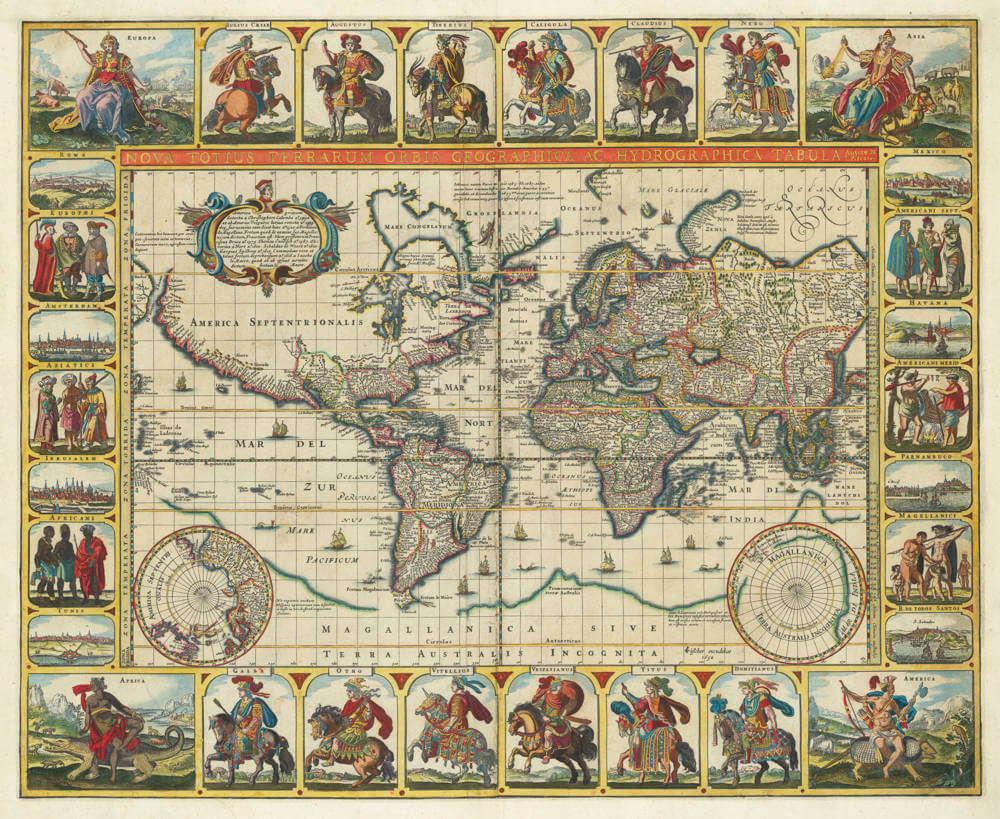
Nova Totius Terrarum Orbis Geographica Ac Hydrographica Tabula Autore N I Piscator
First Published
Amsterdam, 1637
This Edition
Amsterdam, 1652
Size
45.0 x 54.5 cms
Technique
Condition
See description
Price
This Item is Sold
Description
[Separate publication]
The Twelve Caesars World Map—Heightened in Gold
Fine example of Claes Janszoon Visscher’s stunning and rare world map. Known as the Twelve Caesars Map, it is famous for the inclusion of the mounted Roman emperors in the decorative borders. This example is attractively heightened in gold.
Visscher’s maps are known as some of the most splendidly ornate of the seventeenth century. This world map is one of four with embellished panels that Visscher issued between 1614 and 1652. The initial state of this planisphere was published in 1637, one year before Visscher made a double-hemisphere map of the world. Pieter Goos engraved the latter and Shirley surmises that he also likely engraved this piece. The present example is the fifth and final state, dated 1652.
All states of the map are of utmost rarity, and lacking in nearly all collections.
The World on Mercator Projection, Claes Janszoon Visscher, Amsterdam 1637
Map 8: Claes Jansz Visscher, Map of the world on Mercator's projection, 1637. (Niedersächsische Landesbibliothek, Hannover)
States:
8.1 First state, by Claes Jansz Visscher, 1637
8.2 Second state, idem, 1639
8.3 Third state, idem, 1640
8.4 Fourth state, idem, 1646
8.5 Fifth state, idem, 1648
8.6 Sixth state, idem, 1649
8.7 Seventh state, idem, 1652
First state, by Claes Jansz Visscher, with date 1637
NOVA TOTIUS TERRARUM ORBIS GEOGRAPHICA AC HYDROGRAPHICA TABULA / Auctore N. | I. Piscator
- No bar scale
- [Amsterdam]: CJVisscher excudebat | 1637
- 1 map: copper engraving and etching; 45 x 54.5 cm (30 x 44.5 cm map only)
In 1637 Claes Jansz Visscher published a map of the world on Mercator's projection, which in layout is similar to the maps published earlier by Blaeu and Van den Keere. The title in capitals runs along the top edge of the map image. The two polar hemispheres are placed in the bottom corners of a large hypothetical Southland (MAGALLANICA SIVE TERRA AUSTRALIS INCOGNITA) which is interrupted in the area of the most southern portion of South America and near New Guinea. Visscher's imprint is to the left of the southern hemisphere.
The interior of North America is occupied by a large oval cartouche containing twelve lines of Latin text about the discovery of America. The legend refers to the discoveries by Columbus and Vespucci (erroneously dated 1592 and 1599) and to the travels by Drake, Cavendish, Van Noort, Sebald de Weert, Joris van Spilbergen and Jacob le Maire. In the northeast, Davis Strait passes into a large frozen sea (MARE CONGELATUM) which is linked to Hudson Bay. Here a legend refers to Henry Hudson, but the toponyms relate also to other English explorations, such as the one undertaken by Thomas Button (Buttons Baij)(Map 8, ill. 2). The course of the St. Lawrence River is extended far to the west. Surprisingly, the engraver did not go to the trouble of enlarging the coasts of Spitsbergen using more recent Dutch knowledge.
The map is framed by four decorative borders. Allegorical figures of the four continents appear in the four corners. The series of prints by Adriaen Collaert after Maerten de Vos (Hollstein IV, nos. 471-74) served as the model. The six emperors on horseback in the top and bottom borders are copies, sometimes in reverse, after prints by Antonio Tempesta (The Illustrated Bartsch 35, New York, 1984, pp. 326-37, nos. 596-607). Top border: EUROPA; IVLIVS CÆSAR; AVGVSTVS; TIBERIVS; CALIGVLA; CLAVDIVS; NERO; and ASIA. Bottom border: AFRICA; GALBA; OTHO; VITELLIVS; VESPASIANVS; TITVS; DOMITIANVS; and AMERICA.
In the side borders, town views alternate with costumed figures. Left border: ROMA; EVROPAEI; AMSTERDAM; ASIATICI; IERVSALEM; AFRICANI; and TVNIS. Right border: MEXICO; AMERICANI SEPT.; HAVANA; AMERICANI MERID; PARNAMBUCO; MAGELIANICI; and B. DE TODOS SANTOS.
The cartouches and borders of this engraved map were etched in Visscher's workshop.
(Schilder Monumenta Cartographica Neerlandica Volume VI, map 8)
The Mapping of the World
Claes Janszoon Visscher
Amsterdam, 1639 [Shirley was unaware of the earlier first state with date 1637].
45 x 565 mm.
'Nova Totius Terrarum Orbis
Geographica Ac Hydrographica Tabula
Auctore N.I. Piscator' 'C.J Visscher
excudebat 1639'.
[Separate publication]
Following his world map of 1638 on two hemispheres (Entry 346) Claes Visscher prepared a second world map in 1639. This is on Mercator's projection and is in similar style to the maps earlier in the century by Blaeu and Jansson. Visscher's map has been updated geographically to show discoveries around Hudson's Bay; it also shows an extended St. Lawrence river, perhaps copied from Hondius' world map of 1617 or a later derivative. There is a magnificently decorated border including twelve Roman emperors on richly caparisoned horses, six panels of groups of national figures, and six vignettes of the principal towns. In the corners are scenes depicting the four continents, with the personages representing Asia, Africa and America seated astride a camel, a crocodile, and an armadillo respectively.
The engraver is not named but it could well be Pieter Goos who engraved the companion hemispherical world map a year earlier. The same error, attributing the discovery of America to the years 1592/1599, is repeated.
Later states of the planispherical map are known with the dates 1640, 1648, 1649 and 1652, and also (according to Koeman) without date. The 1652 issue sometimes appears in Jansson's Novus Atlas and in composite atlases of the latter half of the seventeenth century. A world map in plano was still being offered in a Visscher map catalogue of c.1682.
BL Maps C.7.e.3 (state 1, 1639); Clements (state 2, 1640); state 3 (1948) noted by the author; 1649 state recorded by Maria Simon in Claes Jansz Visscher, Freiburg, 1958; BN Ge.CC.1336 (state 5, 1652).
Wagner 333 (1639) and 370 (1652).
(Rodney Shirley map 350)
Rarity
The map was issued as a separate publication and is of utmost rarity. It is lacking in most collections.
Significance
The map is only one of nine Dutch single-sheet world maps with decorated borders that were published in the 17th Century.
Condition description
Heightened in Gold. Old color, recently refreshed. Trimmed to neat lines, with margins extended. Minor repairs along centerfold. Minor paper tear in top left image, invisibly repaired on verso. Minor thinness and reinforcements on verso. Overall a highly desirable example of an exceptionally rare and important map of the world.
Claes Janszoon Visscher 1587-1652
Nicolaes Visscher I (son) 1618–1679
Nicolaes Visscher II (grandson) 1649-1702
Elisabeth Visscher (widow of N. Visscher II)
Claes Jansz(oon) Visscher: A Cartographic Luminary of the Dutch Golden Age
Early Life and Apprenticeship
Claes Jansz(oon) Visscher, born on April 23, 1587, in Amsterdam, was a quintessential figure of the Dutch Golden Age, a period renowned for its flourishing culture, science, and trade. Coming from a family of artists, his father, Jan Claesz Visscher, was an engraver who likely introduced Claes to the intricacies of the craft from a young age. This early exposure to engraving and drawing under his father's mentorship laid the groundwork for Claes's illustrious career in cartography.
Claes's education in the arts was typical of the time, where young artists would apprentice under a master, learning through observation and practice. Given his family background, Claes would have had an intimate knowledge of the techniques of engraving, which was a critical skill for mapmaking during the period.
Career and Contributions
Claes Jansz Visscher's career took off in the early 17th century, a time when Amsterdam was becoming the epicenter of global trade and, consequently, cartography. Maps were not just navigational tools but also symbols of power and knowledge, reflecting the wealth and curiosity of the Dutch Republic. Visscher's maps were distinguished by their artistic embellishments, including coats of arms, allegorical figures, and scenes from mythology or daily life, which made them as much works of art as they were functional maps.
Claes Jansz. Visscher apprenticed with Cornelis Claesz., the foremost publisher of maps and pilot guides at the time. This collaboration is evidenced by several works, including maps and engravings, where Visscher's contributions are acknowledged. Visscher's apprenticeship or close working relationship with publishers like Cornelis Claesz was pivotal in shaping his career in mapmaking and engraving.
One of his early notable works was a map of the British Isles in 1616, which demonstrated his capability to blend geographical accuracy with artistic flair. This map, like many of his others, was highly sought after by collectors and navigators alike. His maps often included detailed town views, which were in vogue, providing a visual record of cities and landscapes as they appeared at the time.
The "Orbis Terrarum Typus" and Other Works
In 1638, Visscher produced one of his most celebrated works, the "Orbis Terrarum Typus," which was engraved by Pieter Goos. This map was notable for its hemispheric presentation of the world, reflecting the latest geographical knowledge while maintaining Visscher's signature decorative style.
Visscher's work also included significant contributions to regional cartography. His maps of the Netherlands were particularly detailed, reflecting the importance of accurate maps for trade and defense in a region crisscrossed by waterways and crisscrossed with political boundaries.
Legacy and Influence
Claes Jansz Visscher's influence on cartography was profound. His maps were not only used for navigation but also as status symbols, adorning the walls of the wealthy and educated. His style, characterized by detailed engraving and artistic embellishments, set a standard that influenced other cartographers of his time and beyond.
Visscher's business acumen was also noteworthy. He was not just a mapmaker but also a publisher who understood the market for cartographic products. His publications included atlases and individual maps, which were often sold in sets or bound together by purchasers, indicating a savvy approach to the market's demands.
Death and Continuation of Legacy
Claes Jansz Visscher died on June 19, 1652, in Amsterdam. His son, Nicolaes Claesz Visscher, continued the family business, maintaining the high standards set by his father. The Visscher name remained synonymous with quality in cartography for several generations, illustrating the lasting impact of Claes's work.
Conclusion
Claes Jansz Visscher's biography is not just about the life of a mapmaker but is emblematic of the Dutch Golden Age's spirit of exploration, artistry, and commerce. His maps were instruments of discovery, tools for governance, and canvases for artistic expression, making him one of the most influential cartographers of his era. Through his work, Visscher captured the world as it was known, leaving a legacy that continues to be admired for its blend of beauty and precision.
Antique Maps - A Collector's Guide
For nearly a century the members of the Visscher family were important art dealers and map publishers in Amsterdam. The founder of the business, Claes Janszoon Visscher, had premises near to those of Pieter van den Keere and Jodocus Hondius whose pupil he may have been.
From about 1620 he designed a number of individual maps, including one of the British Isles, but his first atlas consisted of maps printed from plates bought from van den Keere and issued as they stood with some additions of his own, including historical scenes of battles and sieges for which he had a high reputation.
Some maps bear the latinized form of the family name: Piscator. After Visscher's death his son and grandson, both of the same name, issued a considerable number of atlases, constantly revised and brought up to date but most of them lacking an index and with varying contents.
The widow of Nicholaes Visscher II carried on the business until it finally passed into the hands of Pieter Schenk.
(Moreland & Bannister).
Related Categories
Related Items


<BR>
Abraham Ortelius<BR>
Caspar Vopelius")