Leen Helmink Antique Maps
Antique map of Batavia by Jacob van Schley after Adolf van der Laan
Stock number: 19649
Zoom ImageCartographer(s)
Jacob van Schley after Adolf van der Laan
Title
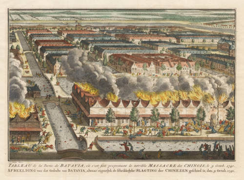
Tableau de la Partie Batavia, ou s'est fait proprement le terrible Massacre des Chinois, le 9 Octob. 1740. Afbeelding van dat Gedeelte van Batavia, alwaar eigentlyk de schrikkelyke Slagting der Chinezen geschied is, den 9 Octob. 1740.
First Published
The Hague, 1763
This Edition
1740
Size
20 x 28 cms
Technique
Condition
mint
Price
$ 1,250.00
(Convert price to other currencies)
Description
Bird's eye view of the 1740 Batavia massacre.
French and Dutch title under the print. Verso blank. Hand-coloured copper engraving by Jacobus van der Schley, published in 1763 in The Hague by Pieter de Hondt in Vies des governors généraux, avec l'abrégé de l'histoire des etablissemens Hollandois aux Indes Orientales; (.), J.P.L. du Bois.
The image is a reduced copy of an unobtainable large broadsheet of 1741 by artist Adolf van der Laan.
The view is also the most detailed early view of Batavia, showing the city center with canals and canal houses. North is at the left, where the back entrance of Batavia castle can be seen with the warehouses. On the far right the City Hall and the Portuguese church are visible. On the top of the view is citadel Rotterdam, the eastern entrance to the city. Chinatown is in the foreground, with the house of the Captain of the Chinese in the lower right. He tried to escape in womans' dress but was recognized and captured.
Condition
Thick paper with wide margins. Strong and even impression of the copperplate. Mint condition.
Transcription and translation of the title
Afbeelding van dat gedeelte van BATAVIA, alwaar eigentlyk de Schrikkelyke Slagting der CHINEZEN geschied is, den 9. Octob. 1740.
Image of that part of BATAVIA, where the terrible massacre of the CHINESE actually took place, on October 9, 1740.
Related Categories
Related Items
