Leen Helmink Antique Maps
Antique map of Africa Tanger by Braun and Hogenberg
The item below has been sold, but if you enter your email address we will notify you in case we have another example that is not yet listed or as soon as we receive another example.
Stock number: 19645
Zoom ImageCartographer(s)
Georg Braun and Frans Hogenberg (biography)
Title
Tingis/Tzaffin/Septa/Arzilla/Sala
First Published
Cologne, 1572
Size
32.6 x 47.8 cms
Technique
Condition
mint
Price
This Item is Sold
Description
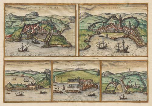
Five city views on one sheet of 16th century Africa: Tangier, Tzaffin, Ceuta, Asilali, and Sale. Including many detailed depictions of Portuguese and Arab sailing ships from the age of exploration.
Braun and Hogenberg's Civitates Orbis Terrarum was the first and best town atlas with city views from around the world.
It was an extensive work, issued in six volumes from 1572 to 1617. Of the more than five hundred sheets with city views, only five Braun & Hogenberg sheets offered the European audience a first view of cities outside Europe and the Mediterranean: four from the Portuguese strongholds in Africa, Arabia and Asia, and one of the Americas. This makes these five sheets of highest significance to the early voyages of discovery.
The text descriptions of the cities, here in French edition, were written by Georg Braun. They translate as follows:
TINGIS (Tangier)
TINGIS, which the Portuguese call Tangar, a large and ancient city not far from the Strait of Gibraltar, began to yield obedience to the Lord of Ceuta during the times when the Goths ruled the Kingdom of Granada, and until Arzila came under the power of the Moors, it has always been politically noble & well inhabited & admirable for battles & pompous in all kinds it is forced to. Its territory is not very fertile nor suitable for fostering grains: but it has an abundance of all fruits. Three leagues from it, there are some fairs, the lanes are laid out in crosses, & they abound in high, mixed fruits. The city remained prosperous until Arzila was conquered by the Portuguese, for then the inhabitants, frightened by the noise & tumult of war, found their belongings and retreated to Fez.
SEPTA (Ceuta)
SEPTA, called Seupta by the Portuguese, which is the same as the one founded by the Romans at the mouth of the Strait of Gibraltar, was once the capital city of all Barbary. The Romans adorned it with warriors and all that was necessary for a city. It was also well-populated and stocked with all necessary things, both food and inhabitants, and governed by a king. But the Moors have held it since then and fortified it, placing a garrison there. It was also well-supplied with all necessary provisions, from food to livestock.
TAZAFFIN
TAZAFFIN, a beautiful city in the land of Africa, surrounded by walls since the mountains, rising to a castle well-towered, equipped with towers, and with houses, and a tower of wonders. It was taken by the Christians in 1508, on the 10th day of July, by the lieutenant of King Emanuel named Diego Dalam.
Arzilla (Arzeila)
ARZILLA, which the Africans call Arzella, is a spacious city, situated on the coast of the Ocean, built by the Romans, about three leagues from the Strait of Gibraltar, and opposite to Septa. It was captured by the Moors, who held it for two hundred years. It was taken by the Christians in the year 1471, on the day of August, by King Emanuel, and newly repopulated and fortified.
Sala (Chellah)
The old city of two names, Sala, that is to say, the old and the new, which are not far from the Strait of Gibraltar, facing Septa. The old one was under Christian rule in the year 1314, and the other, modern one, was captured by the Christians in the year 1471, on the day of August, by King Emanuel, and newly repopulated and fortified.
Georg Braun (1541-1622)
Frans Hogenberg (c.1536-1588)
In 1572 Frans Hogenberg, who engraved maps for Ortelius, together with another noted engraver of the time, Georg Hoefnagel, compiled and issued in Cologne a City Atlas intended as a companion work to Ortelius' "Theatrum Orbis Terrarum". Entitled "Civitatis Orbis Terrarum" and edited by Georg Braun, the six volumes of this famous work were issued between the years 1572 and 1618 and contained in all more than 500 city plans and views.
The atlas provides a fascinating sixteenth-century picture of the principal cities and towns in Europe, Asia, Africa and even America and records details of public buildings, heraldic devices and rural and domestic scenes, besides many street names.
Towns are usually shown in bird's-eye view, set in picturesque and romantic backgrounds with figures of inhabitants in local dress placed boldly in the foreground.
Although some of the city views had been included in earlier works like Munster's Cosmographia, in most instances they were the first views to appear in print.
The Braun and Hogenberg plates eventually passed to Jan Jansson who reissued the plans in Amsterdam in 1657, having removed the costumed figures which, of course, by this time were no longer of contemporary interest.
(Moreland and Bannister)


