Leen Helmink Antique Maps
Antique map of by John Septimus Roe for the British Admiralty
The item below has been sold, but if you enter your email address we will notify you in case we have another example that is not yet listed or as soon as we receive another example.

Stock number: 19543
Zoom ImageCartographer(s)
John Septimus Roe for the British Admiralty
Title
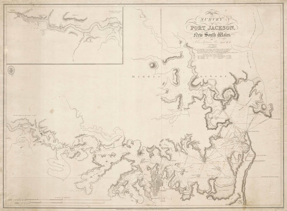
Survey of Port Jackson, New South Wales
First Published
London, 1826
This Edition
1826 first edition first state
Size
44.3 x 60.7 cms
Technique
Condition
excellent
Price
This Item is Sold
Description
Seminal navigation chart of Port Jackson, surveyed in 1822 by the great John Septimus Roe, and published by J. & C. Walker for the British Admiralty in 1826.
"London : Published according to Act of Parliament at the Hydrographical Office of the Admiralty, 1826".
Scale: [ca. 1:35 000]. Cartographic Note: Ungraduated. Lines of latitude & longitude through Sydney Observatory. Greenwich meridian. Scale in statute and nautical miles. Inset: continuation of Paramutta River, at same scale but "is an eye sketch".
Here in the elusive first state of 1826.
A second state was issued in 1839, with the chart number 1069 added.
A third state is held by the National Maritime Museum in Greenwich with corrections up to 1848, and two large compass roses added.
A fourth state has corrections up to 1856.
Early 19th century Admiralty charts are inherently rare, and we can't find any record of any state of this chart having been sold at auction or through the trade.
Young John Septimus Roe (born 1797) made a rapid career in the Phillip Parker King's four expeditions of 1817-1818, 1819, 1820 and 1821-22, in the latter he lost the sight in his right eye when he fell 50 feet from the masthead onto the deck in bad weather.
"Back in Sydney, Roe carried out a survey of Sydney Harbour. Despite the capsizing of his boat on 19 August 1822, with the loss of four lives, the survey was completed, to be published by the Admiralty in 1826."
Note that the chart was made only 34 years after the arrival of the First Fleet in 1778.
Condition
With pencil navigation tracks and anchorage, Linen backed for use at sea. overall in excellent condition.
Related Categories
Related Items


