Leen Helmink Antique Maps
Early navigation chart of Port Jackson

Stock number: 19539
Zoom ImageCartographer(s)
the British Admiralty
Title
Port Jackson
First Published
London, 1859
This Edition
London, 1884
Size
63 x 96 cms
Technique
Condition
discoloured but very good
Price
This Item is Coming Soon
Description
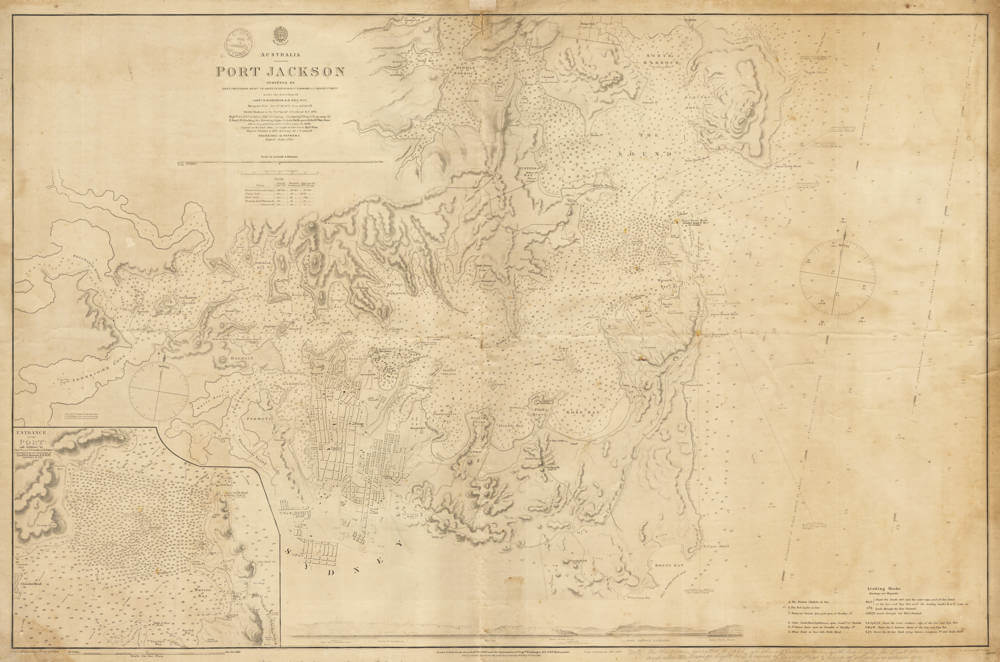
Australia - Port Jackson / Surveyed by Lieut. J. Hutchison etc ... 1857
Hydrographic Office
Price Two & Sixpence
With the round shop stamp of "F.C. JONES PRINT & BOOKSELLER SYDNEY"
London Published at the Admiralty 11th Feb 1859 under the superintendence of Capt Washington R.N. F.R.S. Hydrographer.
Large corrections Feb 1884.
Engraved by J. & C. Walker
Very large and detailed navigation chart for Port Jackson (Sydney Harbour).
With a large scale inset chart of the entrance of the port in the lower left, as well as a profile view of the entrance along the bottom of the chart.
The chart has many soundings in fathoms, as well as magnetic bearings.
With the following interesting manuscript pencil notes in the lower margin:
Admiralty buildings on Garden Island probably commenced 1883-84 - J.H. Watson
Note: On this plan, corrected to 1886, are shown 2 Vaucluse towers with Red lights, for East channel; and also the Orange light on S.E. corner of Sow and Pigs [Bar]: None of which are shown on the plan which is only corrected up to 1882.
Condition
Mounted on linen for use at sea. Overall browning, no restorations or meaningful imperfections. Very authentic look and feel. Clear signs of use, overall in very good condition.
Related Categories
Related Items


