Leen Helmink Antique Maps
Antique map of Java by Chatelain


Stock number: 19501
Zoom ImageCartographer(s)
Henri Abraham Chatelain (biography)
Title
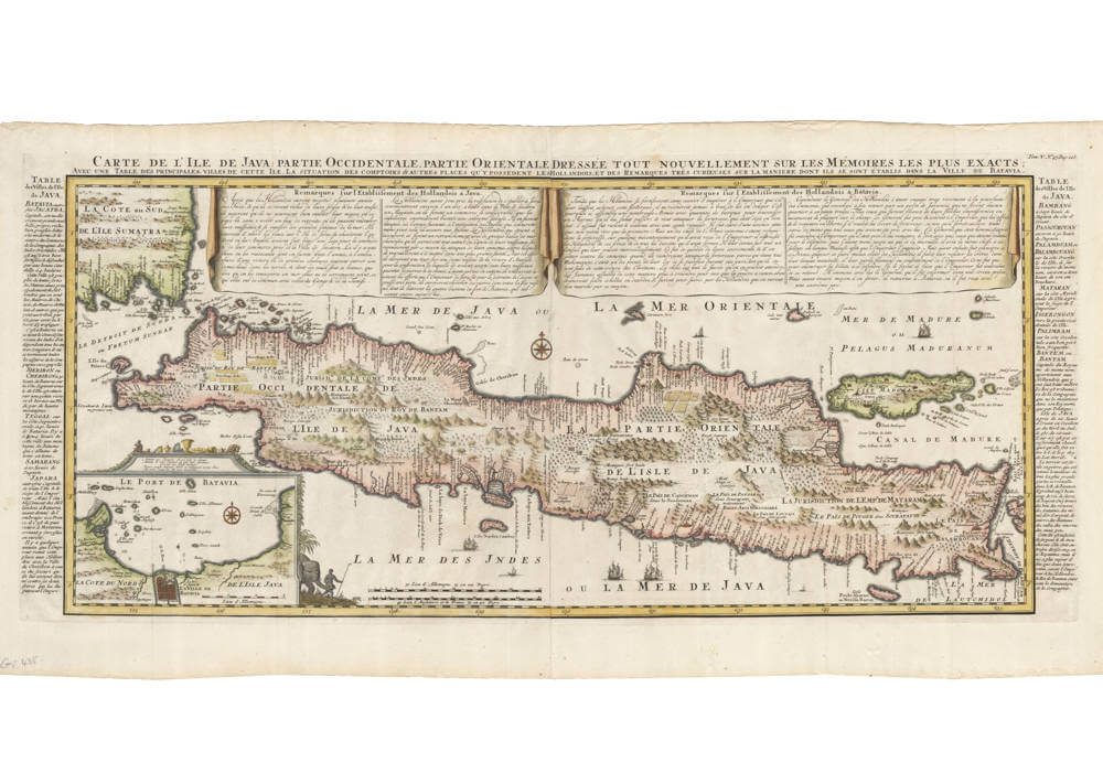
Carte de l'Isle de Java Partie Occidentale, Partie Orientale
First Published
Amsterdam, 1719
Size
38 x 86.5 cms
Technique
Condition
excellent
Price
This Item is Sold
Description
One of the most decorative maps of the island of Java.
Condition
Strong and even imprint of the copperplate. No imperfections or restorations. Wide margins all around. Excellent collector's example of a sought-after map.
Decorative inset of Batavia roads in the lower left. Extensive description of the cities and villages of Java in the side panels. Two large drapery text cartouches describe the history of the Dutch on the island.
"An attractive and important large-scale map of Java published in Volume V of Henri Abraham Chatelain's encyclopaedic 'Atlas Historique' published in Amsterdam in 1719. Modelled on Hadrien Reland's important Dutch map of a few years earlier, the superb topographical detail is complemented by drapery style cartouches and side panels which provide a full French text description of the Island, its topography, history, flora, fauna and inhabitants. A detailed inset bottom left shows the coastal approaches and environs of Batavia, present-day Jakarta. A most attractive and decorative large-scale map of the Island, one of the finest large-scale maps of Java produced in the 18th century."
(Barron).
Henri Abraham Chatelain (1684-1743)
Chatelain was a Huguenot pastor of Parisian origins. He lived consecutively in Paris, St. Martins, London (c. 1710), the Hague (c. 1721) and Amsterdam (c. 1728). Chatelain was a skilled artist and knew combining a wealth of historical and geographical information with delicate engraving and an uncomplicated composition. Groundbreaking for its time, this work included studies of geography, history, ethnology, heraldry, and cosmography. His maps with his elegant engraving are a superb example from the golden age of French mapmaking.The publishing firm of Chatelain, Chatelain Frères and Chatelain & Fils is recorded in Amsterdam, from around 1700-1770, with Zacharias living "op den Dam" (Dam Square) in 1730.
Henri Abraham Chatelain, his father Zacharie Chatelain (d.1723) and his younger brother Zacharie Junior (1690-1754), worked as a partnership publishing the Atlas Historique, Ou Nouvelle Introduction à L'Histoire under several different Chatelain imprints, depending on the Chatelain family partnerships at the time of publication. The atlas was published in seven volumes between 1705 and 1720, with a second edition appearing in 1732. The volumes I-IV with a Third edition and volume I with a final edition in 1739.
Henri Abraham Chatelain, whose "Atlas Historique" was one of the most expansive Dutch encyclopedias of the age. First published in 1705, Chatelain's Atlas Historique was part of an immense seven-volume encyclopedia. Although the main focus of the text was geography, the work also included a wealth of historical, political, and genealogical information. The text was compiled by Nicholas Gueudeville and Garillon with a supplement by H.P. de Limiers and the maps were engraved by Chatelain, primarily after charts by De L'Isle. The atlas was published in Amsterdam between 1705 and 1721 and was later reissued by Zacharie Chatelain between 1732 and 1739.
(Mayers)


