Leen Helmink Antique Maps
Antique map of Hangzhou by Merian

Stock number: 19369
Zoom ImageTitle
Xuntien alias Quinzay.
First Published
Frankfurt, 1638
Size
25.4 x 18.1 cms
Technique
Condition
mint
Price
$ 525.00
(Convert price to other currencies)
Description
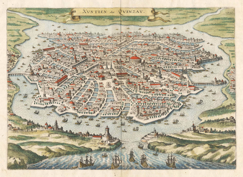
The first western map of any Chinese city. Entirely based on Marco Polo's description.
Attractive bird's eye view of Hangzhou, the ancient Imperial Capital of China. Published in 1638 by Matthias Merian the Elder.
The image is an artistic impression after Marco Polo's description of the city of Quinsay (or Kinsay, Xuntien), which he visited in the late 1200s.
This depiction of the city has an interesting history.
It was first published in woodcut form by the great French explorer and cartographer André Thevet, in his book La Cosmographie Universelle, first printed in 1575 in Paris by Pierre l'Huillier. In that book, Thevet included a number of imaginary views and maps of the Far East that he derived from Marco Polo's texts.
Then in Antwerp around 1590, Daniel Cellarius (Daniel Keller) in cooperation with Gerard de Jode published a wall map of Asia (Asiae nova descriptio) in eight sheets. It survives in only one copy, in the Niedersächsische Staats- und Universitätsbibliothek Göttingen. In the upper right-hand corner of the wall map there is a cartouche containing a bird’s-eye view of Quinsay, a (mirrored) copy after Thevet. A description of the city from Marco Polo with reference to Thevet is in the cartouche below the view (Consulo A. Thevetum, "I/we consulted A. Thevet").
In 1638 Merian also borrowed the Quinsay image from Thevet, added many details, and published his version in copperplate of Xuntien alias Quinzay in Pierre d’Avity’s Neuwe Archontologia cosmica (Frankfurt, 1638, following p. 680). That is the map depicted and described here.
In 1657, Johannes Janssonius published an eight volume atlas of plans and views of the major towns of the world. It was a companion to his Atlas Maior series, that was a direct competitor to Joan Blaeu's Atlas Maior, which also had companion town books. In order to outperform Blaeu, Janssonius published an eight-volume book of town plans, consisting mainly of copies of the Blaeu town plans as well as copies of the old town plans that had been published by Braun and Hogenberg in their Civitates Orbis Terrarum, the first proper town atlas. Neither of these had any maps of cities in the mysterious empire of China, and Janssonius added his version of Xuntien alias Quinsay, at more than twice the size of Merian's. Jansson's Atlas Maior and the companion twon books were not nearly as succesful as Blaeu's originals, it is for that reason that his large version of the Quinsay view is almost unobtainable.
Condition
Strong impression of the copperplate. Thick paper, with very wide margins. No restorations or imperfections. Overall a pristine example in beautiful later hand colour, executed in the appropriate style and technique of the period.
The Book of Ser Marco Polo the Venetian
The Venetian merchant Marco Polo visited Hangzhou (Kinsay) in the late 13th century. In his book, he devotes three detailed chapters to the old capital Kinsay or the City of Heaven and he records that the magnificent city was "greater than any in the world" and that "the number and wealth of the merchants, and the amount of goods that passed through their hands, was so enormous that no man could form a just estimate thereof."
Polo's account exaggerates the city's size, although it has been argued that the "hundred miles" of walls would be plausible if Chinese miles were intended instead of Italian ones and that the "12,000 stone bridges" might have been a copyist error born from the city's 12 gates.
(Wikipedia)
Matthäus Merian (1593-1650)
Matthäus Merian der Ältere (or "Matthew", Matthias, "the Elder", or "Sr."; 22 September 1593 – 19 June 1650) was a Swiss-born engraver who worked in Frankfurt, Germany for most of his career, where he also ran a publishing house. He was a member of the patrician Basel Merian family.
Born in Basel, Merian learned the art of copperplate engraving in Zürich. He next worked and studied in Strasbourg, Nancy, and Paris, before returning to Basel in 1615. The following year he moved to Oppenheim, Germany where he worked for the publisher Johann Theodor de Bry, who was the son of renowned engraver and traveler Theodor de Bry.
In 1617, Merian married Maria Magdalena de Bry, daughter of the publisher, and was for a time associated with the de Bry publishing house. In 1620, when Oppenheim was destroyed by fire during the Spanish occupation, they moved back to Basel, but three years later returned to Germany, this time to Frankfurt. They had four daughters and three sons, including Matthäus Merian the Younger. Maria Magdalena de Bry died in 1645 and the following year Matthäus married Johanna Sibylla Heim.[1] Five years later, Matthäus died, leaving his wife with two small children, Anna Maria Sibylla Merian (born 1647), who later became a pioneering naturalist and illustrator, and a son, Maximilian, who died before his third birthday.
n 1623 Merian took over the publishing house of his father-in-law after de Bry's death. In 1626 he became a citizen of Frankfurt and could henceforth work as an independent publisher. He spent most of his working life in Frankfurt.
Early in his life, he had created detailed town plans in his unique style, e.g. a plan of Basel (1615) and a plan of Paris (1615). With Martin Zeiler (1589–1661), a German geographer, and later (c. 1640) with his own son, Matthäus Merian (der Jüngere, i.e. "the Younger" or "Jr.") (1621–1687), he produced a series of Topographia. The 21-volume set was collectively known as the Topographia Germaniae. It includes numerous town plans and views, as well as maps of most countries and a World Map—it was such a popular work that it was re-issued in many editions. He also took over and completed the later parts and editions of the Grand Voyages and Petits Voyages, originally started by de Bry in 1590 and included volumes India Orientalis and America Occidentalis.
Merian's work inspired the Suecia Antiqua et Hodierna by Erik Dahlberg. The German travel magazine Merian is named after him.
He was also noted for the finesse of his alchemical illustrations, in books such as the Musaeum Hermeticum (1678) and Atalanta Fugiens (1618). He undertook the engravings for the encyclopaedic work of insect natural history De Serpentibus, compiled by John Jonston. This tradition would be taken up by his daughter.
Matthäus Merian died after several years of illness in 1650 in Langenschwalbach, near Wiesbaden.
After his death, his sons Matthäus Jr. and Caspar took over the publishing house. They continued publishing the Topographia Germaniae and the Theatrum Europaeum under the name Merian Erben (i.e. Merian Heirs).
(Wikipedia
André Thevet (1516-1590)
André Thevet traveled extensively and wrote prolifically. Few sixteenth-century writers covered more territory or wrote more ambitiously. While serious doubt exists as to whether some of the writing published under his name was really his, Thevet remains an important figure in early geographical writing.
Born in Angoulême around 1516, Thevet’s early education was apparently limited; we know little of his early life. Thevet became a Franciscan friar, and his first excursion into the world occurred in about 1550, when he accompanied the Cardinal Jean de Lorraine on travels into Italy and the Mediterranean basin. Shortly thereafter, Thevet published his Cosmographie de Levant, a compendium of facts about the people, places, flora and fauna of the area. The section on the Nile, for example, includes a woodcut depiction of a crocodile (p. 138), something contemporary readers would most likely never have seen. The intriguing illustrations have been attributed to Bernard Salomon.
Thevet's experience as a traveler attracted the attention of Nicolas Durand, Chevalier de Villegagnon, who was preparing to found a colony in what is today Brazil. He asked Thevet to accompany the expedition as its confessor. Thevet fell ill during the voyage and had to return to France after only ten weeks in Brazil. Using his own observations, however, combined with information gained from other travelers, Thevet quickly produced his Singularitez de la France Antarctique. The first edition was published in Paris in 1557.
After the publication of the Singularitez, Thevet received royal recognition and eventually became cosmographer of the Valois court. He began his most ambitious work, the Cosmographie Universelle, which described and defined every part of the known world.
While today Thevet is seen largely as a compiler and editor of experiences that belonged to others, his works, with their extensive descriptions and lavish illustrations, give a broad picture of the historical and geographical knowledge of the sixteenth century.
(University of Virginia Library)
Related Categories
Related Items


