Leen Helmink Antique Maps
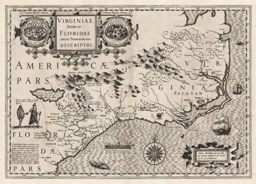
Antique map of Virginia, Southeast by Jodocus Hondius I
The item below has been sold, but if you enter your email address we will notify you in case we have another example that is not yet listed or as soon as we receive another example.
Stock number: 19257
Zoom ImageCartographer(s)
Jodocus Hondius (biography)
Title
VIRGINIAE Item et FLORIDAE Americae Provinciarum nova DESCRIPTIO.
First Published
Amsterdam, 1606
This Edition
1606 first edition
Size
34.2 x 48.4 cms
Technique
Condition
mint
Price
This Item is Sold
Description
The exceptionally rare true first edition of 1606 of the most important and influential map of Virginia and the Carolinas to appear in the 17th century. By the great Jodocus Hondius the Elder.
Condition
In pristine condition. Dark and even impression of the copperplate. No imperfections or restorations. No repairs, not cleaned, untouched. A very desirable collector's example of an unobtainable map.
The Mapping of North America
The map is a composite largely of John White's Virginia and Jacques le Moyne's Florida as interpreted by Theodore de Bry in 1590 and 1591 respectively. 'Chesepioock Sinus' representing Chesapeake Bay is still shown in its White delineation. At the end of this year, 1606, a party of Englishmen left England to begin arguably the most important colonisation of North America in this very bay, at Jamestown. Within just a few years the entire region would be completely revised cartographically. The area south towards C.S. Romano Hispanis is entirely drawn from White. It is, however, given too much latitude, extending as far as 32.5 degrees, some 2 degrees too far. S. Augustine, however, is shown at the correct latitude. The combined effect is a compacted coastline for the present day States of Georgia and South Caroline.
The area of French Floridae originally comes from de Bry's map Floridae Americae Provinciae of 1591. Here a new interpretation of the cartography had made this map notable; however, the author has noted that it actually first appeared on the wall map of America by Cornelis Claesz., c.1602. The new rendition of le Moyne's geography is caused by the great lake which is moved from central Florida north so that the R. de May (St. John's River) now flows in a south-easterly direction. It was probably encouraged by the depiction on a number of maps of a similarly flowing large R. Secco like that on the FLORIDAE et APALCHE, by Cornelis Wytfliet of 1597. Its influence was considerable. Taken up by Hondius, this error was popularised by the major success of his atlas and lasted for some seventy years. According to Cumming some placenames appear from other sources, namely that of Jean Ribaut. In the Apalatcy Mountains references are made to the presence of both gold and silver. The map is embellished with various game including a wild turkey. Examples of Indian villages in Florida and Virginia appear in cartouches either side of the title. The map's scale and decorativeness make it very sought after.
This map accompanies the first edition of Gerard Mercator's atlas by Jodocus Hondius, and is the only regional one of North America present. Intended to be a grand comprehensive work, with the first part originally appearing in 1585, by Mercator's death in 1594 only two parts had been published. Continued by his family, it was still incomplete for the 1602 edition, lacking most importantly a section on the Iberian peninsula. During this time it was also competing with the remarkably successful atlas of Abraham Ortelius which averaged almost one edition per year. By 1604 Jodocus Hondius was flourishing, and in that year acquired all of the plates from Mercator's descendants. He immediately set about engraving many new maps to augment and complete the work, amongst which was a set of the four continents. He also had the original text expanded by Petrus Montanus. In the following year he brought out Mercator's Ptolemy, and in 1606 his first edition of the general atlas which proved instantly popular, selling out within a year. After Jodocus' death in 1612, the atlas continued to be published under his name by his widow (the editions of 1612-19). Then it was published by his second son Henricus. With the 1634 edition Joannes Janssonius became involved in the publication. The map is used in all editions of the so-called Mercator-Hondius-Janssonius atlas until 1638.
(Philip Burden map 150).
Shedding the Veil
This was the principal foundation map of the Southeast until the Ogilby-Moxon map of 1672. Though based largely on the maps of John White and Jacques Le Moyne, Koeman (Southeast) notes that subsequent cartographers usually followed Hondius rather than his prototypes.
A large fresh water lake, source of the River May (St Mary's River?), may be the Okefenoke Swamp, or conversely may be a vestige of the Veraazanian Sea intimated by Le Moyne. The map extends from the Chesapeake through St. Augustine.
The White /de Bry Americae pars, Nunc Virginia dicta, primum ab Anglis inuenta . . ., published in Frankfurt in 1590, was the principal mother-map of the cartography of the Chesapeake and Outer Banks, as well as "the first printed map of this degree of detail and accuracy for any part of the present area of the United States" (-Cumming). De Bry improves upon the circa 1585 White manuscript with data presumably gained from the second Virginia voyage of 1587-88.
(Thomas Suárez).
The Southeast in Early Maps
Though this map by Hondius is based on two earlier maps, those of White 1590 and Le Moyne 1591, subsequent cartographers usually followed this work rather than the earlier maps. It thus became the Most important type map of the region until the Ogilby-Moxon "Discription of Carolina" ca. 1672; and its influence, both direct and indirect, extends into the middle of the eighteenth century.
That part of the territory settled by the French in 1562-65 depends chiefly upon Le Moyne's map. The gold bearing mountains of Apalatcy, the lake fed by the great waterfall, the lake with the unseen shore, Lake Sarrope, the French names for the rivers, the location for the French fort at Port Royal: these and many other details are based on Le Moyne. However, there are important changes. The great lake with the opposite shore invisible, which in Le Moyne lies in a southwesterly direction from the mouth of the River May, into which it empties, has been moved northward to the foothills of the Apalatcy Montes. This makes the River May flow in a southeasterly direction instead of in the A-shaped course given by Le Moyne. Probably in this Hondius was influenced by the other maps of the region - Mercator 1569, Ortelius 1584, Wytfliet 1597 - in which the great river Sola flows in a southeasterly direction from the mountains.
However, the R. de May (River May) is Le Moyne's name for St. Johns River in Florida, on which Fort Caroline was built and which flows in a northerly direction from its sources and lakes in Florida until near its mouth, when it turns eastward toward the sea. By putting the great lake and the direction of the flow of the River May to the northwest of its mouth and changing the accompanying topographical features and Indian settlements, Hondius created geographical misconceptions of the region, which lasted for nearly a century and a half. Also he moved the latitude of the mouth of the River May from 29°30' N.L. (St. Johns is 30°25') to 31°20'. This is actually the latitude of the Altamaha in Georgia, the first river above Florida which has its source in the Appalachian range. These factors undoubtedly encouraged the continuance of erroneous beliefs in the minds of subsequent explorers and cartographers. St. Marys River, which lies between St. Johns and the Altamaha, rises in the Okefenokee Swamp. Some writers think that the River May is the St. Marys River and that the great lake is the Okefenokee Swamp.
(Cumming).
Jodocus Hondius (1563-1612)
Jodocus Hondius the Younger (son) (1594-1629)
Henricus Hondius (son) (1597-1651)
Jodocus Hondius the Elder, one of the most notable engravers of his time, is known for his work in association with many of the cartographers and publishers prominent at the end of the sixteenth and the beginning of the seventeenth century.
A native of Flanders, he grew up in Ghent, apprenticed as an instrument and globe maker and map engraver. In 1584, to escape the religious troubles sweeping the Low Countries at that time, he fled to London where he spent some years before finally settling in Amsterdam about 1593. In the London period he came into contact with the leading scientists and geographers of the day and engraved maps in The Mariner's Mirrour, the English edition of Waghenaer's Sea Atlas, as well as others with Pieter van den Keere, his brother-in-law. No doubt his temporary exile in London stood him in good stead, earning him an international reputation, for it could have been no accident that Speed chose Hondius to engrave the plates for the maps in The Theatre of the Empire of Great Britaine in the years between 1605 and 1610.
In 1604 Hondius bought the plates of Mercator's Atlas which, in spite of its excellence, had not competed successfully with the continuing demand for the Ortelius Theatrum Orbis Terrarum. To meet this competition Hondius added about 40 maps to Mercator's original number and from 1606 published enlarged editions in many languages, still under Mercator's name but with his own name as publisher. These atlases have become known as the Mercator/ Hondius series. The following year the maps were re-engraved in miniature form and issued as a pocket Atlas Minor.
After the death of Jodocus Hondius the Elder in 1612, work on the two atlases, folio and miniature, was carried on by his widow and sons, Jodocus II and Henricus, and eventually in conjunction with Jan Jansson in Amsterdam. In all, from 1606 onwards, nearly 50 editions with increasing numbers of maps with texts in the main European languages were printed.
(Moreland and Bannister)
