Leen Helmink Antique Maps
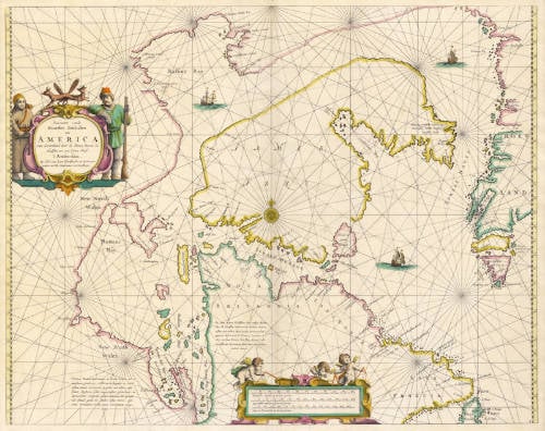
Antique map of California by van Loon
The item below has been sold, but if you enter your email address we will notify you in case we have another example that is not yet listed or as soon as we receive another example.
Stock number: 18740
Small ImageCartographer(s)
Johannes van Loon (biography)
Title
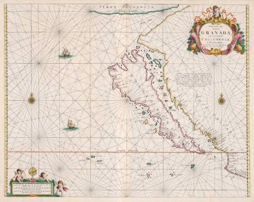
Pascaerte van Nova Granada, en't Eylandt California
First Published
Amsterdam, 1666
This Edition
1668
Size
42.5 x 54.5 cms
Technique
Condition
excellent
Price
This Item is Sold
Description
The first, the most famous, most wanted and the rarest of all sea charts of California as an island. Only a handful of examples have survived. Due to its rarity and historical importance, the map is legendary.
The map is not a mere copy of any of the existing charts at the time, so van Loon must have received new information. The Van Loon is a unique chart that does not rely on the earlier charts by Colom and Doncker.
On the mainland, the chart has a fascinating Latin note on California that is not on the Goos chart. It is copied from the Henricus Hondius/Johannes Jansson 1636 map os 1636 (see example here). It reads:
California a prioribus Geographis semper habita fuit quaedam pars continentis: at capta per Hollandos ab Hispanis tabula quaedam Geographica, compertum est, insulam esse. et continere, ubi latissima est, 500 leucas. A. Cap Mendocino vero usque ad c. S. Lucae repertum testibus tabulae praedicta et Francisco Gaulo extendi in longitudinem 1700 leucarum.
"Earlier Geographers have always represented California as part of the mainland. But from a certain map that the Dutch have captured from the Spanish, it has been found that it is an island, with broadest width of 500 Spanish leguas. However, from Cabo de Mendocina down to the Cape of San Lucas the aforementioned map and Francisco Gaulo (the Gaul?) testify that it is 1700 Spanish leagues long."
There is no certainty what chart the Dutch managed to capture from the Spanish or when, because there were many naval battles between the adversaries who were at war, but it is possible that it happened during Joris van Spilbergen's naval attack on the Mexican port of Salahua, which was commanded by Sebastián Vizcaíno, who had explored the California coast in 1602. It is possible that the Spanish map had been made in good faith, it has also been suggested that the map was intelligence disinformation, to make sure that Dutch fleets could be trapped in the Gulf of California, thinking there was a safe way out at the northern end.
"This is the second of two important charts introduced in the 1666 edition of Johannes van Loon's Zee Atlas.
Along with the similar Pieter Good chart of the same year, this is one of the most desirable of all California as an island maps. They are the first folio maps dedicated to this curious cartographic phenomenon. It has not been proved which appeared first, but it is believed that the van Loon most probably takes pride of place. This is because the van Loon atlas was the most innovative of the two, while Goos largely drew upon existing charts.
Many authorities have applied the date of 1661 to its first appearance. However, it is not known to be present in any earlier edition than that of 1666."
(Burden 395)
Condition
Good imprint of the copperplate. Very attractive early "shop" color from the van Loon publishing house. Excellent collector's condition.
Johannes van Loon (1611-1686)
Joannes van Loon was an accomplished mathematician and astronomer. His first cartographic involvements were with Theunis Jacobsz during the 1640s. From 1650 he worked with Joannes Janssonius, engraving amongst other worksthe plates for his Celestial Atlas by Cellarius, 1660.
In 1661 he published his first work with his brother, Gillis; the 'Zee Atlas' contained thirty-five maps. In 1666 the plates were Jan Jansson van Waesberge, with whom he then co-published the atlas. This edition was expanded to forty-seven maps, and by 1676 there were fifty.
(Burden)
