Leen Helmink Antique Maps & Atlases
www.helmink.com
Janssonius
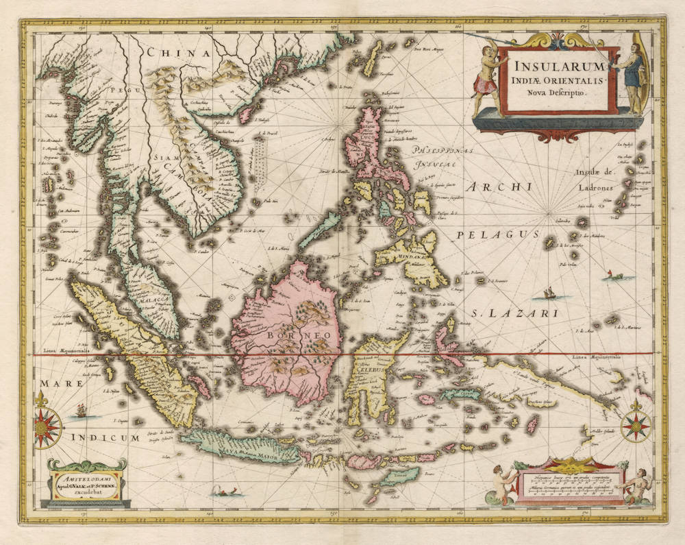
Insularum Indiae Orientalis Nova Descriptio
Certificate of Authentication and Description
This is to certify that the item illustrated and described below is a genuine antique
map, print or book that was first produced and published in 1633, today 392 years ago.
April 16, 2025
Cartographer(s)
Janssonius
First Published
Amsterdam, 1633
This edition
1700
Size
38.9 x 50.4 cms
Technique
Copper engraving
Stock number
18646
Condition
mint


Description
"The map reproduced here is proof of the fact, that Janssonius' maps also in their content could equal, or even surpass those of his competitor Blaeu.
On this 'New Description of the East Indies' of 1633, Janssonius presents information about the area, that does not appear on any printed map by any other contemporary cartographer. This concerns the 'Duyfkens Eylant' to the south of New Guinea: its position and name on this map proves that Janssonius was aware of a journey of discovery to Australia by a Dutch ship of that name, that took place as early as 1605-1606. How he came by this information remains a mystery: Willem Jansz Blaeu had been nominated cartographer to the VOC in the same year that this map was first published. In view of the fierce competition between them, this rules Blaeu out as a possible source of information.
This map was reprinted until late in the 17th century. Apart from general pictures such as this, the Dutch contribution to cartographic knowledge of Asia in that period has been conspicuously small. While the Dutch became mapmakers to and of the known world in the 17th century, this scarcity of material regarding Asia is in strong contrast to the many and detailed contemporary maps of areas of the world, where the Dutch did not have comparably strong commercial interests."
(Braeken).
Johannes Janssonius (1588-1664)
Johannes Janssonius, more commonly known to us as Jan Jansson, was born in Arnhem where his father was a bookseller and publisher (Jan Janszoon the Elder). In 1612 he married the daughter of the cartographer and publisher Jodocus Hondius, and then set up in business in Amsterdam as a book publisher. In 1616 he published his first maps of France and Italy and from then onwards he produced a very large number of maps, perhaps not quite rivalling those of the Blaeu family but running a very close second in quantity and quality. From about 1630 to 1638 he was in partnership with his brother-in-law, Henricus Hondius, issuing further editions of the Mercator/Hondius atlases to which his name was added. On the death of Henricus he took over the business, expanding the atlas still further, until eventually he published an 11-volume "Atlas Major" on a scale similar to Blaeu's "Atlas Maior".
The first full edition of Jansson’s English County Maps was published in 1646 but some years earlier he issued a number of British maps in the Mercator/Hondius/ Jansson series of atlases (1636–44); the maps were printed from newly engraved plates and are different from the later 1646 issue and are now rarely seen. In general appearance Jansson’s maps are very similar to those of Blaeu and, in fact, were often copied from them, but they tend to be more flamboyant and, some think, more decorative.
After Jansson's death his heirs published a number of maps in an "Atlas Contractus" in 1666 and later still many of the plates of his British maps were acquired by Pieter Schenk and Gerard Valck, who published them again in 1683 as separate maps.
(Moreland and Bannister)