Leen Helmink Antique Maps & Atlases
www.helmink.com
Jansson
Insularum MOLUCCARUM Nova Descriptio
Certificate of Authentication and Description
This is to certify that the item illustrated and described below is a genuine antique
map, print or book that was first produced and published in 1633, today 393 years ago.
October 13, 2026
Cartographer(s)
Jansson
First Published
Amsterdam, 1633
This edition
Size
38 x 50 cms
Technique
Copper engraving
Stock number
19875
Condition
excellent
Description
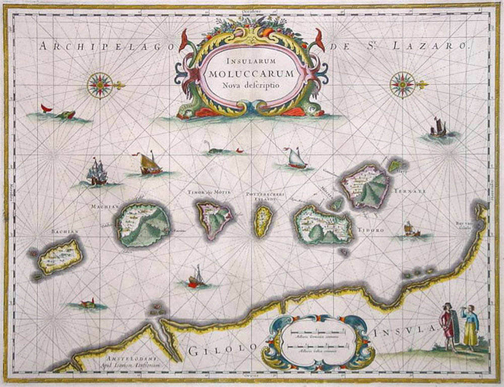
This decorative map presents the Moluccas, the cluster of small volcanic islands in the eastern part of the present-day Indonesian archipelago that constituted the original Spice Islands. The map is oriented to the west, so that north lies to the right of the sheet. The principal clove-bearing islands of the northern Moluccas, among them Ternate, Tidore, Motir, and Makian, are shown off the western coast of Gilolo (Halmahera), whose shore is rendered along the lower edge of the composition.
The map is best understood through its descent. The prototype was a copperplate engraved for Jodocus Hondius the Younger, intended for an ambitious world atlas of his own that was never realised, his early death in 1629 ending the project. Willem Blaeu acquired this and a number of other Hondius plates from the estate that same year and, following the customary practice of the period, replaced the engraved name with his own imprint, issuing the Moluccas plate as Molvccae Insulae Celeberrimae to launch his Atlantis Appendix of 1630. In the keen commercial rivalry between the Blaeu house and the partnership of Henricus Hondius and Joannes Janssonius, Janssonius answered with the present competing map, closely following the Blaeu model, under the title Insularum Moluccarum Nova Descriptio from 1633. It appeared in successive editions of the Atlas Novus, later the Atlas Major; after Janssonius's death in 1664 the firm continued under his son-in-law Johannes van Waesbergen, and in 1676 the surviving copperplates were dispersed at auction, many ultimately acquired by Pieter Schenk and Gerard Valk.
The cartographic interest of the map is inseparable from the commercial history of the region. The spice trade was geographically concentrated to a remarkable degree: cloves grew only on the small northern islands of Ternate and Tidore and their immediate neighbours, while nutmeg and mace came solely from the Banda Islands to the south. Pepper, by contrast, was cultivated widely across the East Indies and beyond. This concentration of the most valuable spices in so confined an area drew Portuguese, Spanish, Dutch, and English interests into prolonged competition, and the Dutch East India Company progressively imposed a monopoly over production and export during the seventeenth century. The map is characteristic of the Dutch decorative manner. The seas are animated with European and local vessels, two of them engaged in a naval encounter, together with sea monsters, while fortified islands and warships emphasise the contested character of these waters. A decorative title cartouche, an ornate cartouche with nautical scale bars, compass roses, and a pair of figures in local Moluccan dress complete the ornamental design.
Johannes Janssonius (1588-1664)
Johannes Janssonius, more commonly known to us as Jan Jansson, was born in Arnhem where his father was a bookseller and publisher (Jan Janszoon the Elder). In 1612 he married the daughter of the cartographer and publisher Jodocus Hondius, and then set up in business in Amsterdam as a book publisher. In 1616 he published his first maps of France and Italy and from then onwards he produced a very large number of maps, perhaps not quite rivalling those of the Blaeu family but running a very close second in quantity and quality. From about 1630 to 1638 he was in partnership with his brother-in-law, Henricus Hondius, issuing further editions of the Mercator/Hondius atlases to which his name was added. On the death of Henricus he took over the business, expanding the atlas still further, until eventually he published an 11-volume "Atlas Major" on a scale similar to Blaeu's "Atlas Maior".
The first full edition of Jansson’s English County Maps was published in 1646 but some years earlier he issued a number of British maps in the Mercator/Hondius/ Jansson series of atlases (1636–44); the maps were printed from newly engraved plates and are different from the later 1646 issue and are now rarely seen. In general appearance Jansson’s maps are very similar to those of Blaeu and, in fact, were often copied from them, but they tend to be more flamboyant and, some think, more decorative.
After Jansson's death his heirs published a number of maps in an "Atlas Contractus" in 1666 and later still many of the plates of his British maps were acquired by Pieter Schenk and Gerard Valck, who published them again in 1683 as separate maps.
(Moreland and Bannister)