Leen Helmink Antique Maps & Atlases
www.helmink.com
Pierre Mortier
Carte Particuliere Des Costes De L Afrique Depuis C. Del Gado Jusques Rio ...
Certificate of Authentication and Description
This is to certify that the item illustrated and described below is a genuine antique
map, print or book that was first produced and published in 1708, today 318 years ago.
June 27, 2026
Cartographer(s)
Pierre Mortier
First Published
Amsterdam, 1708
This edition
1708 first edition
Size
39.5 x 58 cms
Technique
Copper engraving
Stock number
19757
Condition
mint
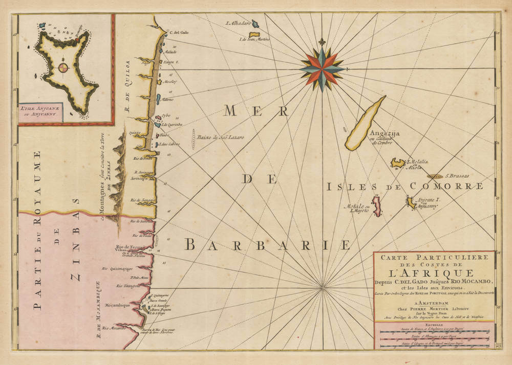
Description
Pierre Mortier's rare chart of Eastern Africa and the western Indian Ocean, one of the first to focus on the Comoro Islands. It names all three islands as well as the disputed island of Mayotte, here also named Motale. The inset on the upper left shows one of the Comoro Islands, Anjoane or Ndzuani. The coastline focuses on Mozambique from Cape Delgado in the north to Rio Mocambo, just south of the city of Mozambique. The sources used are mainly Portuquese, reflected by the nomenclature used on the map. In addition, the chart has been embellished with a strong compass rose on the upper centre.
The chart was added in 1708 to Mortier's "Neptune Francois", a highly succesful sea atlas first issued simultaneously in Paris and Amsterdam by Hubert Jaillot and Pierre Mortier in 1693.
The atlas was highly successful, and is famous for the beautiful execution of the copper engravings and for the magnificent colouring of the charts.
This chart is known in two later states with the address of Gerard van Keulen, who had acquired the plates sometime before 1726.
Condition
Thick paper, wide margins. Vibrant original colour. First edition, first state. From a rare plano binding, meaning no centrefold. A magnificent copy of a very rare sea chart.