Leen Helmink Antique Maps & Atlases
www.helmink.com
Braun and Hogenberg
Mexico / Cusco
Certificate of Authentication and Description
This is to certify that the item illustrated and described below is a genuine antique
map, print or book that was first produced and published in 1572, today 454 years ago.
July 26, 2026
Cartographer(s)
Braun and Hogenberg
First Published
Cologne, 1572
This edition
Size
27 x 48 cms
Technique
Copperplate engraving
Stock number
19577
Condition
mint
Description
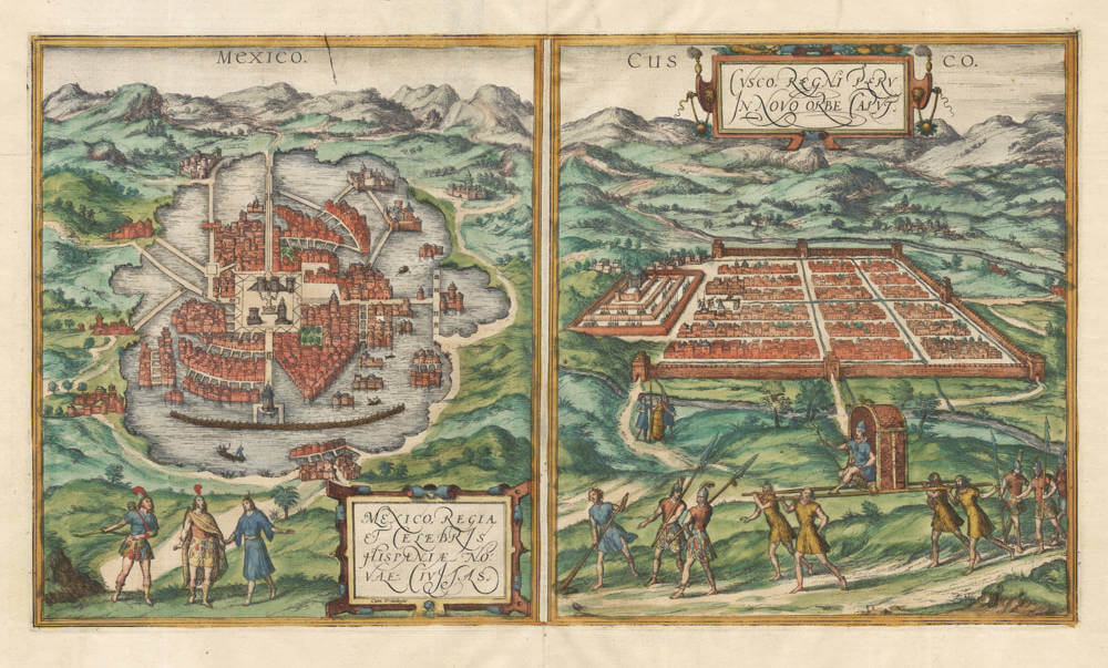
Braun & Hogenberg's Civitates Orbis Terrarum was the foremost city atlas of the 16th Century.
Nearly all city views in the Civitatis are of towns and cities in Europe. The only view of cities in the Americas is this sheet, showing Mexico City and Cusco in two side by side panels.
The map/view of Mexico City, capital of the Aztec empire, is based on the first printed map of the city by the conquestador Hernán Cortés, who presented it in his letters to his Emperor Charles V. The city is in the middle of a lake, which made it a military stronghold. The city is designed around a central square with the big pyramid temple where the human sacrifices took place. In the foreground we see the Aztec emperor Montezuma.
The map/view of Cusco goes back to earlier versions by Munster and Ramusio, and is based on Pizarro's accounts of the conquest of the Inca empire. The Inca emperor Atahualpa, who was ambushed and later killed by the Spanish, is depicted in a carriage in the foreground.
George Braun's descriptive text on the back translates as follows:
CUSCO
This part of the New World, which extends more to the south and which the Spaniards call "terra firma," includes and embraces both Brazil and Peru. The region of Cusco is a metropolitan and main city, which is greatly favored by nature and, on account of the fortress and its invincible castle, mainly by the great nobility and the principal princes. It is abundant with riches, which provide for the buildings of temples, public areas, and a pleasant leisure of life, as well as with good and straight pathways along with many streets, like those of France or Spain.
No one inhabits this city except for nobles, who possess the city alone, along with the lofty and magnificent houses, high columns, and grand palaces. Princes of lower rank reside partly in the city and partly in the fields and pleasant places surrounding it. The main buildings of this city are constructed from stones cut into square shapes, growing and forming intersections in many different areas of the city, where there is not a single street that is not straight.
A beautiful stream flows through this city, descending from the peak of a nearby mountain, surrounded by roads built with great beauty and skill, upon which a green field or garden is arranged. A castle with a formidable appearance stands on the summit of this mountain, from which the whole region can be seen, and around it are houses and buildings for the common people, built from small stones, the roofs of which are made of straw, like in new constructions. There are mines close by, from which much silver is extracted. The castle has artillery and is well fortified but is so steep that it cannot be accessed without difficulty. At its foot, one sees a very beautiful green plain, which forms a sort of wide garden filled with various trees and shrubs, giving the city a charming appearance.
The houses of the bourgeoisie in the city are equipped with fortified doors and are well-armed. The city has abundant fabrics and textiles, a large quantity of lead, tin, and a considerable amount of silver, but little gold.
MEXICO
Mexico, or Tenochtitlan, in New Spain of the Mexican Province, is the most renowned, well-situated, and well-fortified city, built in a lake, larger in size than Seville or Cordoba. The road leading to this city is excellent and wide, spacious and pleasant to see. Likewise, its streets are straight and well-laid out, such that they can easily be traveled from one end to the other.
It also has many public squares, where the market is continuously held, and where an incredible amount of goods are bought and sold; one of these squares is twice as large as that of Salamanca, entirely surrounded by arcades, where over sixty thousand people come daily to trade. In this square, there is a great house in the form of an auditorium, where judicial matters and legal disputes are settled.
There are many mosques and houses of idols, where their religious rituals are carried out. Among these buildings is one that is the most remarkable, dedicated to the idol Huichilobos, with a magnificent courtyard surrounded by a high wall of great grandeur, the handiwork of the nobility. Moreover, there is a royal palace, greatly adorned, where the mighty Montezuma resided with a splendid retinue of lords and gentlemen of his court, showing his power and dominion over the surrounding provinces.
As for the grandeur and magnificent riches of this king Montezuma, concerning his past stories and the history of these cities, one can find more ample and detailed explanations in books dealing with the discoveries of the New World, written by Mr. Abraham Ortelius, the famous geographer of our time.
Georg Braun (1541-1622)
Frans Hogenberg (c.1536-1588)
In 1572 Frans Hogenberg, who engraved maps for Ortelius, together with another noted engraver of the time, Georg Hoefnagel, compiled and issued in Cologne a City Atlas intended as a companion work to Ortelius' "Theatrum Orbis Terrarum". Entitled "Civitatis Orbis Terrarum" and edited by Georg Braun, the six volumes of this famous work were issued between the years 1572 and 1618 and contained in all more than 500 city plans and views.
The atlas provides a fascinating sixteenth-century picture of the principal cities and towns in Europe, Asia, Africa and even America and records details of public buildings, heraldic devices and rural and domestic scenes, besides many street names.
Towns are usually shown in bird's-eye view, set in picturesque and romantic backgrounds with figures of inhabitants in local dress placed boldly in the foreground.
Although some of the city views had been included in earlier works like Munster's Cosmographia, in most instances they were the first views to appear in print.
The Braun and Hogenberg plates eventually passed to Jan Jansson who reissued the plans in Amsterdam in 1657, having removed the costumed figures which, of course, by this time were no longer of contemporary interest.
(Moreland and Bannister)