Leen Helmink Antique Maps & Atlases
www.helmink.com
John Arrowsmith
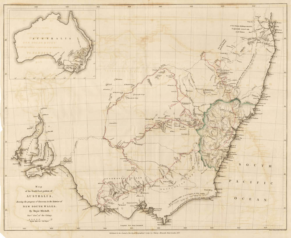
Map of the South East portion of Australia, shewing the progress of discovery, ...
Certificate of Authentication and Description
This is to certify that the item illustrated and described below is a genuine antique
map, print or book that was first produced and published in 1837, today 189 years ago.
July 22, 2026
Cartographer(s)
John Arrowsmith
First Published
London, 1837
This edition
1837 first and only edition
Size
cms
Technique
Stock number
19513
Condition
excellent
Description
Very rare early 1837 broadside map of New South Wales, showing in detail the results of Thomas (or Major) Mitchell's three explorations of 1831, 1835 and 1836 into Southeastern Australia.
Major Mitchell was the Surveyor General of the Colony.
The map was drawn and engraved by John Arrowsmith in London, and published for the Journal of the Royal Geographical Society by John Murray's publishing firm.
This 1837 map predates John Arrowsmith's regular 1838 atlas version of the same area and is much rarer.
This map here is not in the overview of Arrowsmith's Australian maps project led by Dorothy Prescott for the University of Melbourne.
John Arrowsmith (1790-1873)
John Arrowsmith (1790-1873) was one of the most influential British cartographers of the nineteenth century. Hailing from a family of cartographers and geographers, he inherited his family’s mapmaking business and created one of the most popular and accurate atlases in the mid-nineteenth century. He produced the largest scale maps, constructed mostly from official government sources, of the British colonies during the early to mid nineteenth century period.
John Arrowsmith was born at Winston, County Durham, England. He was the nephew of Aaron Arrowsmith, another English cartographer.
In 1810 he joined his uncle in the cartography business. They built on Aaron's A map exhibiting all the new discoveries in the interior parts of North America 1811 version which was heavily based on information provided by the Hudson's Bay Company, Indian maps, and British Navy sea charts to produce and publish an updated map: North America in 1821. Their contributions to Canadian cartography led to Mount Arrowsmith, situated east of Port Alberni on Vancouver Island, British Columbia, being named for them.
Aaron's sons Aaron Jr. and Samuel were substantially younger than John but inherited their father's business when they were young men (21 and 18 respectively) when Aaron Sr. died in 1823. John took the £200 left to him by his uncle and began working on his own. Aaron Jr and Samuel did not have the skills of their father and cousin and their contributions to cartography were minimal. Regardless, the three Arrowsmiths were founding members of the Geographical Society of London in 1830. Aaron Jr. left the family firm in 1832, and upon the death of Samuel in 1839, John purchased the assets and merged them into his own business.
The Arrowsmith River in Western Australia was named by Sir George Grey after Arrowsmith, who later produced the maps for the published journals of Grey's two Western Australian expeditions. In 1863 he received the gold medal of the Royal Geographical Society, which was what the Geographical Society of London was known as after gaining the patronage of King William IV.
He died at home in Hereford Square, South Kensington, London on 1 May 1873.
(Wikipedia)
Thomas Mitchell (1792-1855)
Sir Thomas Livingstone Mitchell (15 June 1792 – 5 October 1855), often called Major Mitchell, was a Scottish surveyor and explorer of Southeastern Australia. He was born in Scotland and served in the British Army during the Peninsular War. In 1827 he took up an appointment as Assistant Surveyor General of New South Wales. The following year he became Surveyor General and remained in this position until his death. Mitchell was knighted in 1839 for his contribution to the surveying of Australia.
(Wikipedia)
Sir Thomas Livingstone Mitchell (born June 15, 1792, Craigend, Stirlingshire, Scot.—died Oct. 5, 1855, Sydney, N.S.W. [Australia]) was the surveyor general of New South Wales who explored and surveyed widely in Australia.
As a soldier in the Peninsular War in Spain (1811–14), Mitchell worked in topographical intelligence. He became a major in 1826 but was placed on half pay. In 1827 he went to New South Wales as assistant surveyor general to John Oxley at Sydney. He succeeded Oxley in 1828, assuming responsibility for roads and bridges in 1829 and in 1830 sole responsibility for the whole department. By 1830 he had established permanent routes from Sydney to Parramatta and to Liverpool and through the Blue Mountains.
In 1831–32 Mitchell explored between the Castlereagh and Gwydir rivers. In 1835 he traced the Darling River from the point at which Charles Sturt had left off in 1828 to the junction with the Murray. In 1836 his exploration of land around the Murray River led him to call the area Australia Felix (Happy Australia; later, Victoria state). The area was settled rapidly thereafter.
In 1837 Mitchell went on leave to England and wrote Three Expeditions into Eastern Australia (1838) and began a campaign for knighthood (granted in 1839). He also published his Peninsular War battle plans in 1840.
Mitchell returned to Australia in 1841 and in 1844 was elected to the legislative council. His fourth expedition (1845–46) sought in vain an overland route to Port Essington, but he surveyed a vast area.
Again on leave in England (1847–48), Mitchell wrote Journal of an Expedition into the Interior of Tropical Australia (1848) and The Australian Geography (1850), used as a textbook in Australian schools.
(Brittanica)