Leen Helmink Antique Maps & Atlases
www.helmink.com
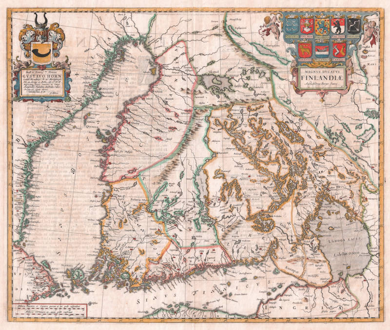
Joan Blaeu
Magnus Ducatus Finlandiae
Certificate of Authentication and Description
This is to certify that the item illustrated and described below is a genuine antique
map, print or book that was first produced and published in 1659, today 367 years ago.
July 26, 2026
Cartographer(s)
Joan Blaeu
First Published
Amsterdam, 1659
This edition
Amsterdam, 1659 FIRST EDITION
Size
43.2 x 51.8 cms
Technique
Copper engraving
Stock number
18746
Condition
excellent
Description
The first printed map of Finland. A rare item because it appears in Atlas Maior editions only. Here in the important first edition.
The map is primarily based on the cartographic work of Anders Bure (also known as Andreas Bureus). Bure's 1626 six-sheet wall map, "Orbis Arctoi Nova et Accurata Delineatio," was a significant advancement in mapping Scandinavia and served as a foundational reference for Blaeu's depiction of Finland. Blaeu acknowledged Bure's contributions, and the accuracy of his map reflects the meticulous surveys conducted by Bure in the early 17th century.
Blaeu's the Grand Atlas of the 17th Century World
This remarkably accurate-looking map was published by John Blaeu in 1662, and is the first printed map of the Grand Duchy of Finland, taken from the Scandinavian maps of Anders Bure.
At the time of publication, Finland was a Grand Duchy of the Swedish Empire, with most of its settlements concentrated in the south and south-west, still an area with a large Swedish-speaking minority, particularly in 'Finlandia, Nylandia, Caiania' and 'Tavastia'. The south-eastern frontier region, around Lake Ladoga [Ladozhskoye Ozero in the USSR] shows two boundaries, one to the west, the other to the east, coloured with a double green and yellow line. The former represents the boundary established at the Treaty of Täyssinä in 1595 by which the Grand Duchy received all of the territory to the north-west of the lake shown then as Savolax. The latter is the more recent boundary determined at the Treaty of Stolbovo which ended the Russo-Swedish War of 1610- 1617. Most of this territory was ceded back to Russia after the USSR-Finnish War of 1940.
Blaeu's title piece incorporates the arms of the provinces of the Grand Duchy: 'Caiania' [Oulu and Vaasa] 'Finlandia' [Turku and Pori], 'Finlandia Septentrionalis' [Lappi] 'Savolaxia' [Kuopio and Mikkeli], 'Tavastia' [Häme], 'Nylandia' [Uusimaa], and 'Carelia' [Karjala]. In the opposite corner, Blaeu gives a dedication to Gustav Horn (1592-1657) of Björnebor [Pori], who was governor of the south-eastern regions of Kexholm and Ingermanland, giving a date of origin of Blaeu's map between 1651 (when Horn was made a Count) and 1657 (the year of his death). The arms of Finland were also relatively recent in origin, being first used in the 1580s.
(Goss).
Significance
Joan Blaeu's 1659 Magnus Ducatus Finlandiae holds the distinction of being the first printed map dedicated exclusively to the Grand Duchy of Finland. Here in the exceptionally rare first edition.
Blaeu's map showcases Finland's intricate network of lakes, rivers, and forests, highlighting the country's diverse topography. The depiction of settlements, fortifications, and administrative divisions offers a comprehensive view of Finland's infrastructure during the 17th century. The map's accuracy is remarkable, considering the period's limited surveying technology, and it reflects the meticulous work of both Bure and Blaeu.
The example here in the first edition, the 1659 Spanish Atlas Major volume on Northern Europe, predating the full 1662 editions. The Spanish edition was unique in its extended publication period, from 1657 to 1672, and was produced in more limited quantities compared to other language editions. Notably, the volumes were printed sequentially and were not uniformly numbered. The final volume, focusing on Spain, was the last to be printed in 1672. However, a fire in Blaeu's workshop in the same year likely affected the distribution and availability of this volume.
Rarity
The map is rare, because it occurs in the prestigious Atlas Major editions only, the most valuable atlas of all time and one that is rarely broken apart into separate maps.
Condition
A strong and even imprint of the copperplate. Wide margins all around. No restorations. Some shinethrough of verso text on verso, overall in excellent condition.
Willem Janszoon Blaeu (1571-1638)
Joan Blaeu (son) (1596-1673)
Cornelis Blaeu (son) (?-c.1642)
Willem Janszoon Blaeu died in October 1638, leaving his prospering business to his sons, Joan and Cornelis, who continued and expanded their father's ambitious plans.
After the premature death of his brother Cornelis in 1642, Joan directed the work alone and the whole atlas series of 6 volumes was eventually completed about 1655. As soon as it was finished he began the preparation of the even larger work, the Atlas Maior, which reached publication in 1662 in 11 volumes (later editions in 9-12 volumes) and contained nearly 600 double-page maps and 3,000 pages of text. This was, and indeed remains, the most magnificent work of its kind ever produced; perhaps its geographical content was not as up-to-date or as accurate as its author could have wished, but any deficiencies in that direction were more than compensated for by the fine engraving and colouring, the elaborate cartouches and pictorial and heraldic detail and especially the splendid calligraphy.
In 1672 a disastrous fire destroyed Blaeu's printing house in the Gravenstraat and a year afterwards Joan Blaeu died. The firm's surviving stocks of plates and maps were gradually dispersed, some of the plates being bought by F. de Wit and Schenk and Valck, before final closure in about 1695.
(Moreland and Bannister)