Leen Helmink Antique Maps & Atlases
www.helmink.com
Visscher
Comitatus Hollandia
Certificate of Authentication and Description
This is to certify that the item illustrated and described below is a genuine antique
map, print or book that was first produced and published in 1630, today 396 years ago.
July 26, 2026
Cartographer(s)
Visscher
First Published
Amsterdam, 1630
This edition
c.1662
Size
46.5 x 56.5 cms
Technique
Copper engraving
Stock number
18738
Condition
excellent
Description
Fifth copy known. The rarest and most decorative of all printed maps of Holland, of which only four copies are recorded. Very decorative borders. The author is unknown, presumably Claes Jansz Visscher.
3rd state with address of Frederick de Wit.
References:
Blonk 'Hollandia Comitatus', Map 54, State 3.
Schilder 'Monumenta Cartographica Neerlandica', Vol. VI, map 74, State 3, as follows:
Schilder 74.11 First state, by an anonymous publisher, [c. 1630]
Copies:
* No copy known. For a description see second state.
Schilder 74.2 Second state, by an anonymous publisher, [after 1635]
COMITATUS | HOLLAN | DIA - Scale: Miliaria Germanica com: / Gemeijne Duitsche mijlen [3=63
mm]; Horæ itineris / Uren gaens [4=60 mm] - [Amsterdam: by an anonymous publisher, after 1635] - 1 map : copper engraving and etching; 46.5 x 56.5 cm
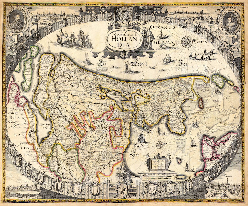
The title is in an oval scrollwork cartouche in the North Sea (OCEANUS GERMANICUS / De Noord Zee). This cartouche is crowned by the coat of arms of the Prince of Orange, placed in front of a curtain. To the right the cartouche is decorated with a couple of costumed figures. An obvious erasure to the left of the cartouche deliberately removed figures on that side (and accidentally part of a ship as well), but we do not know why. In the Zuiderzee (De Zuyder Zee) a cartouche contains a legend of the symbols, and on the front side of the plinth is the Scala miliarium / Mylperck with two bar scales. The sea is enlivened by ships and two compass roses. West is at the top.
The map maker presents this map of Holland in a special way: the map image is bordered by an oval fence of wattle-work, representing the so-called 'Holland in de tuin' ['Holland in the Garden']. The 'garden' is closed at the front by a gate which is decorated by the coat of arms of Holland (the lion, however, is in mirror image). Behind the gate the Maid of Holland keeps watch. On the posts of the fence hang the coats of arms of Holland's towns. In the top corners are oval wrought-iron medallions with the portraits of Frederik Hendrik, Prince of Orange (to the left) and his wife Amalia van Solms (to the right). Towards the centre are views of AMSTELREDAM and DORDRECHT, the bottom corners are occupied by views of the CURIA HOLLANDIÆ (to the left) and HAERLEM. This is the first time that town views on maps of Holland are not shown in oval or rectangular frames. In this way the etcher created a much better spatial effect. Three of the four town views (all except Amsterdam) are based on those engraved by Pieter van den Keere for Guicciardini's Description de touts les Pays-Bas (Arnhem, 1613).
Who was the creator of this beautiful map? All four town views had already appeared on maps published by Claes Jansz Visscher: Haarlem and Dordrecht derive from Visscher's Leo Hollandicus of 1622, the Court of Holland from Visscher's 1630 map of Holland, and Amsterdam appears on both maps. This may point to the creator of this map being in Visscher's workshop. But the engraving and etching themselves are not from Visscher's hand. The map was obviously made to honour Frederik Hendrik, who had much military success as a conqueror of towns. Claes Jansz Visscher had already made a map of Holland in the shape of a lion to honour Frederik Hendrik's brother Maurits. Perhaps Visscher wanted to pay similar hommage to Frederik Hendrik, who had 'locked' the ‘Garden of Holland' with his military successes.
The geographical content obviously follows the mapping of Balthasar Florisz van Berckenrode. The engraver, however, did not simply use a folio-sized map of Holland such as Henricus Hondius's Comitatus Hollandia of 1629, but followed the original wall map of Van Berckenrode published by Willem Jansz Blaeu in 1621. The drawing of the southwestern part of the map corresponds in every detail with the 1621 wall map, and this 1621 wall map differs from the subsequent states of it and from the folio-sized maps. For the small part of Frie land that does not appear on the Van Berckenrode/Blaeu wall map of 1621, the Claes Jansz Visscher 1630 map of Holland served as the model.
With the aid of the geographical content we can estimate the date of this map. As Visscher's 1630 folio map of the province of Holland was still based on Van Deventer's map, the map under discussion must be dated after 1630. The map was already published before 1637, how ever, for in that year Visscher published a new edition of the Van Berckenrode/Blaeu wall map with extensive changes in the map image of the southwestern part. It would not have been logical to use the out-of-date version of the 1621 wall map after it had been updated. The second state of the map has to be dated after 1635 because all the great lakes in North-Holland have been reclaimed. (With special thanks to Dick Blonk for giving me access to his research.)
Copy: * Amsterdam, Rijksprentenkabinet (Atlas Ottens Pf. 6, no. 6)
Literature: Wieder (1918) p. 509
Schilder 74.3 Third state, by Frederick de Wit
In the space between the bar scales and the cartouche with the symbols the following imprint has been added: Frederick de Wit Excudit. No changes have been made in the geographical content.
Copies:
* København, Det Kongelige Bibliotek (1131, 1-0-1680)
* London, The British Library (Maps 32605 [6]).
* Rotterdam, Atlas van Stolk (Suppl. 1600-1650 [1])
(Schilder)
Claes Janszoon Visscher 1587-1652
Nicolaes Visscher I (son) 1618–1679
Nicolaes Visscher II (grandson) 1649-1702
Elisabeth Visscher (widow of N. Visscher II)
Claes Jansz(oon) Visscher: A Cartographic Luminary of the Dutch Golden Age
Early Life and Apprenticeship
Claes Jansz(oon) Visscher, born on April 23, 1587, in Amsterdam, was a quintessential figure of the Dutch Golden Age, a period renowned for its flourishing culture, science, and trade. Coming from a family of artists, his father, Jan Claesz Visscher, was an engraver who likely introduced Claes to the intricacies of the craft from a young age. This early exposure to engraving and drawing under his father's mentorship laid the groundwork for Claes's illustrious career in cartography.
Claes's education in the arts was typical of the time, where young artists would apprentice under a master, learning through observation and practice. Given his family background, Claes would have had an intimate knowledge of the techniques of engraving, which was a critical skill for mapmaking during the period.
Career and Contributions
Claes Jansz Visscher's career took off in the early 17th century, a time when Amsterdam was becoming the epicenter of global trade and, consequently, cartography. Maps were not just navigational tools but also symbols of power and knowledge, reflecting the wealth and curiosity of the Dutch Republic. Visscher's maps were distinguished by their artistic embellishments, including coats of arms, allegorical figures, and scenes from mythology or daily life, which made them as much works of art as they were functional maps.
Claes Jansz. Visscher apprenticed with Cornelis Claesz., the foremost publisher of maps and pilot guides at the time. This collaboration is evidenced by several works, including maps and engravings, where Visscher's contributions are acknowledged. Visscher's apprenticeship or close working relationship with publishers like Cornelis Claesz was pivotal in shaping his career in mapmaking and engraving.
One of his early notable works was a map of the British Isles in 1616, which demonstrated his capability to blend geographical accuracy with artistic flair. This map, like many of his others, was highly sought after by collectors and navigators alike. His maps often included detailed town views, which were in vogue, providing a visual record of cities and landscapes as they appeared at the time.
The "Orbis Terrarum Typus" and Other Works
In 1638, Visscher produced one of his most celebrated works, the "Orbis Terrarum Typus," which was engraved by Pieter Goos. This map was notable for its hemispheric presentation of the world, reflecting the latest geographical knowledge while maintaining Visscher's signature decorative style.
Visscher's work also included significant contributions to regional cartography. His maps of the Netherlands were particularly detailed, reflecting the importance of accurate maps for trade and defense in a region crisscrossed by waterways and crisscrossed with political boundaries.
Legacy and Influence
Claes Jansz Visscher's influence on cartography was profound. His maps were not only used for navigation but also as status symbols, adorning the walls of the wealthy and educated. His style, characterized by detailed engraving and artistic embellishments, set a standard that influenced other cartographers of his time and beyond.
Visscher's business acumen was also noteworthy. He was not just a mapmaker but also a publisher who understood the market for cartographic products. His publications included atlases and individual maps, which were often sold in sets or bound together by purchasers, indicating a savvy approach to the market's demands.
Death and Continuation of Legacy
Claes Jansz Visscher died on June 19, 1652, in Amsterdam. His son, Nicolaes Claesz Visscher, continued the family business, maintaining the high standards set by his father. The Visscher name remained synonymous with quality in cartography for several generations, illustrating the lasting impact of Claes's work.
Conclusion
Claes Jansz Visscher's biography is not just about the life of a mapmaker but is emblematic of the Dutch Golden Age's spirit of exploration, artistry, and commerce. His maps were instruments of discovery, tools for governance, and canvases for artistic expression, making him one of the most influential cartographers of his era. Through his work, Visscher captured the world as it was known, leaving a legacy that continues to be admired for its blend of beauty and precision.
Antique Maps - A Collector's Guide
For nearly a century the members of the Visscher family were important art dealers and map publishers in Amsterdam. The founder of the business, Claes Janszoon Visscher, had premises near to those of Pieter van den Keere and Jodocus Hondius whose pupil he may have been.
From about 1620 he designed a number of individual maps, including one of the British Isles, but his first atlas consisted of maps printed from plates bought from van den Keere and issued as they stood with some additions of his own, including historical scenes of battles and sieges for which he had a high reputation.
Some maps bear the latinized form of the family name: Piscator. After Visscher's death his son and grandson, both of the same name, issued a considerable number of atlases, constantly revised and brought up to date but most of them lacking an index and with varying contents.
The widow of Nicholaes Visscher II carried on the business until it finally passed into the hands of Pieter Schenk.
(Moreland & Bannister).
Frederick de Wit (1629-1706)
Early Life and Beginnings in Amsterdam
Frederick de Wit was born around 1629 in Gouda, a city known for its cultural and intellectual contributions during the Dutch Golden Age. His family was Protestant, and by 1648, 18 or 19 year old De Wit had moved to Amsterdam, a city at the heart of Dutch trade, culture, and mapmaking. Here, he served his apprenticeship under the tutelage of Joan Blaeu, whose family was already famous for producing some of the world's finest atlases and maps.
Establishment in Amsterdam
In 1654, de Wit set up his own printing office and shop, initially named "De Drie Crabben" (The Three Crabs), which was also the name of his residence on Kalverstraat. The following year, he renamed it "De Witte Pascaert" (The White Navigation Chart), signaling his focus on cartography. His early works included a plan of Haarlem in 1648 and illustrations for Antonius Sanderus’s "Flandria Illustrata", but it was his independently engraved map of Denmark in 1659 that marked his entry into the broader mapmaking world.
Cartographic Contributions and Style
De Wit's maps were distinguished by their accuracy, decorative borders, and elaborate cartouches often depicting classical mythology or allegorical scenes. His most famous work, "Nova Totius Terrarum Orbis Tabula," was a world map first published in 1660. The map demonstrated his skill in both geography and artistic design. Over the decades, he produced numerous sea charts, town plans, and wall maps, which were not only navigational aids but also sought after for their beauty and decorative value.
By the 1670s, de Wit was producing larger atlases like the "Atlas Maior" and "Nieuw Kaertboeck van de XVII Nederlandse Provinciën". These atlases combined his own engravings with those he had acquired, showcasing his entrepreneurial spirit. His maps of the Netherlands were particularly notable for their detailed depiction of the Dutch landscape, including cities, waterways, and dykes, reflecting the country's complex relationship with its environment.
Personal Life and Guild Membership
In 1661, de Wit married Maria van der Way, which not only brought him personal happiness but also the privileges of Amsterdam citizenship. This allowed him to join the prestigious Guild of Saint Luke in 1664, which was essential for artists and engravers in the city. His involvement with the guild underscores his standing in the artistic community of Amsterdam.
Later Years and Legacy
De Wit's business thrived, especially after the death of his mentor Blaeu, from which he acquired many copper plates when they were dispersed at auction, positioning him as one of the leading cartographers in Amsterdam. He continued to expand his catalog, ensuring his maps were up-to-date with the latest geographical discoveries. His attention to detail and the aesthetic quality of his work made his maps popular among the elite, scholars, merchants, and navigators alike.
When Frederick de Wit passed away in July 1706, his wife Maria managed the business until 1710. After her death, the vast collection of copper plates was auctioned off, with many going to Pieter Mortier (1661-1711), who used them to further his own publishing empire, Covens & Mortier. In 1721, the copperplates were sold in auction by the heirs of Mortier's widow, and were acquired by the Ottens publishing house in Amsterdam. These transactions illustrate de Wit's lasting influence on the mapmaking industry.
Cultural Impact and Modern Appreciation
De Wit's work encapsulates the spirit of the Dutch Golden Age – a period of unprecedented artistic and scientific achievement. His maps are not merely tools for navigation but are also pieces of art that reflect the cultural pride of the Dutch in their maritime and cartographic prowess. Today, his maps are treasured in collections around the globe, from libraries to smaller, specialized map collections. They are frequently exhibited in museums as exemplars of the Dutch art of cartography, admired for their precision, beauty, and historical significance.
Frederick de Wit's legacy is one of a craftsman whose maps not only charted the physical world but also captured the imagination of those who used them, contributing to the enduring allure of an age when maps were as much about exploration as they were about art.