Leen Helmink Antique Maps & Atlases
www.helmink.com
Janssonius
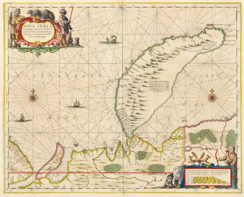
Nova Zemla, Waygats, Fretum Nassovicum, 
Certificate of Authentication and Description
This is to certify that the item illustrated and described below is a genuine antique
map, print or book that was first produced and published in 1650, today 376 years ago.
February 13, 2026
Cartographer(s)
Janssonius
First Published
Amsterdam, 1650
This edition
1650
Size
40.0 x 50.0 cms
Technique
Copper engraving
Stock number
18284
Condition
mint


Description
Important early map of Nova Zembla from Janssonius' sea atlas, also known as 'Water-world' and published as Atlas Novus Volume V.
Very elegant sea chart with two spectacular cartouches, decorated with hunters, polar foxes, polar bears and wallruses. The chart is further embellished with rhumb-lines, two compass roses, two sailing ships, and a sea monster.
The scalebar in the lower right is in the form of a skewed 'checker-board', to reflect the rapidly changing scale of this map in the vertical direction, which is caused by the high lattitudes in combination with the projection method.
Many details are based on the discoveries from the three Dutch expeditions that searched for a Northeast passage to the riches of the East. The wintering place of Willem Barentsz ("Het behouden Huys") is visible in the upper right.
The map is the most decorative and most wanted early map of the region.
Johannes Janssonius (1588-1664)
Johannes Janssonius, more commonly known to us as Jan Jansson, was born in Arnhem where his father was a bookseller and publisher (Jan Janszoon the Elder). In 1612 he married the daughter of the cartographer and publisher Jodocus Hondius, and then set up in business in Amsterdam as a book publisher. In 1616 he published his first maps of France and Italy and from then onwards he produced a very large number of maps, perhaps not quite rivalling those of the Blaeu family but running a very close second in quantity and quality. From about 1630 to 1638 he was in partnership with his brother-in-law, Henricus Hondius, issuing further editions of the Mercator/Hondius atlases to which his name was added. On the death of Henricus he took over the business, expanding the atlas still further, until eventually he published an 11-volume "Atlas Major" on a scale similar to Blaeu's "Atlas Maior".
The first full edition of Jansson’s English County Maps was published in 1646 but some years earlier he issued a number of British maps in the Mercator/Hondius/ Jansson series of atlases (1636–44); the maps were printed from newly engraved plates and are different from the later 1646 issue and are now rarely seen. In general appearance Jansson’s maps are very similar to those of Blaeu and, in fact, were often copied from them, but they tend to be more flamboyant and, some think, more decorative.
After Jansson's death his heirs published a number of maps in an "Atlas Contractus" in 1666 and later still many of the plates of his British maps were acquired by Pieter Schenk and Gerard Valck, who published them again in 1683 as separate maps.
(Moreland and Bannister)