Leen Helmink Antique Maps
Antique map of the World and the continents by van Schagen
The item below has been sold, but if you enter your email address we will notify you in case we have another example that is not yet listed or as soon as we receive another example.
Stock number: 18567
Zoom ImageCartographer(s)
Gerard van Schagen (biography)
Title
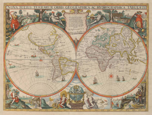
Nova Totius Terrarum Orbis Tabula ex officina G. a Schagen Amstelodami
First Published
Amsterdam, 1682
This Edition
1689
Size
48.3 x 56.0 cms
Technique
Condition
excellent
Price
This Item is Sold
Description
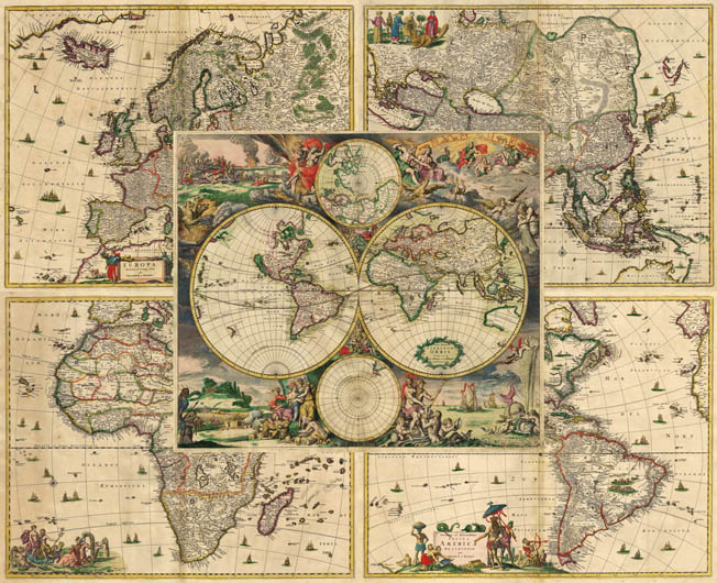
An exceptionally rare complete and matching set of five highly decorative 17th Century maps of the world and of the known continents.
The world map and continent maps offered were published by Gerard van Schagen, a highly talented cartographer and etcher/engraver of 17th Century Amsterdam. Little is known about him because he did not publish atlases himself, but instead supplied his printed maps and even wall maps to prominent publishers like Johannes van Keulen, Frederick de Wit and Nicolaes Visscher II.
The world map here is based on the maritime world map "Orbis Maritimus" by Frederick de Wit, first published in Amsterdam in his sea atlas of c.1668, but is not an exact copy of it. The mythological decorations around the map were designed by Romeyn de Hooghe, the unrivalled artist and etcher who was highly admired by his contemporaries. Frederick de Wit's map as well as this rare version of it are considered supreme examples of Dutch 17th century mapmaking, often refered to as the most beautiful of all world maps from the Dutch Golden Age. They are considered masterpieces, cartographically as well as an art-historically, offering an extraordinary symbiosis of cartography and iconography.
The continent maps that were published with this world map are derived from the classic maps of the continents by Nicolaes Visscher I, first published c.1658. Gerard van Schagen has replaced Visscher's dedication cartouches on these continent maps by scenes from greek mythology, presumably to avoid copyright privilige violations.
"The world map seems to have appeared as an alternative general map only in the English edition of Van Keulen's atlas".
(Rodney Shirley map 514).
This world map must have been used into the 18th century, because in Shirley's corrigenda one further state is recorded with the address changed to Gerard van Keulen.
Condition
The set was found in a c.1689 atlas factice containing a variety of maps by Gerard van Schagen, Nicolaes Visscher and Frederick de Wit. The maps are printed on thick double layer paper. The imprints from the copperplates are strong and even. All maps are in attractive and matching original colour. The America map with some colour offsetting in the upper left cartouche. The map of the world has an old repair to a vertical tear in the center bottom, but no loss of printed area. Overall the set is in excellent collector's condition.
Rarity
This is only the second known example of this set, so far only recorded in one single other example in a composite atlas in the Amsterdam University Library, but that example of the world map has the upper corners reinstated in facsimile.
The world map by itself (i.e. not as part of a set of world and continents) is also of highest rarity, Shirley notes one example in an english 1682 edition of the sea atlas by Johannes van Keulen in the Maritime Museum Prins Hendrik in Rotterdam, and in his corrigenda he notes one example of a later state of this world map with the address of Johannes van Keulen's son Gerard van Keulen, which suggests that state is after 1728.
As far as we have been able to establish, no other examples are known. Young Johannes van Keulen entered the market for sea atlases in 1680, at age 26, and was very ambitious. He bought the stock of his retiring neighbour Hendrick Doncker, and would soon dominate the market. One of his problems for his early sea atlases of the world was that he did not have his own map of the world until 1682. For this reason, early editions of his "Sea Atlas or Water World" contain world maps by others, apparently including this one, but also other ones. Customers could probably choose from a number of world maps that he could include by acquiring them from other publishers. In the course of 1682, mathematician Claes Janszoon Vooght made a large general navigation chart of the world for Johannes van Keulen, on "increasing degrees" (Mercator projection). But as Shirley points out, after 1682 van Keulen's atlases sometimes still contain other publisher's maps of the world, very possibly because of the unfamiliarity of Mercator's projection!
Of the Gerrit van Schagen continent map of America, Burden (map 418) knows three states and presumes a fourth one. Because the Schagen map of America is included in Montanus and Ogilby's "The New and Unknown World or Description of America" it is not rare and is present in the important American collections.
The Gerrit van Schagen maps of Europe, Africa and Asia are of exceptional rarity because, like the map of the world, they were not included in any regular book or atlas.
Dating
Dating of many maps from the second half of the 17th century is approximate, because several succesful publishers like Frederick de Wit, Nicolaes Visscher, Cornelis Danckerts and others had decided not to date their atlas title pages nor their individual maps. Dating of maps and their states is indirect, and based on known dates of the occurence other maps in the same atlas, or of contemporary publisher's catalogues and newspaper advertisements for their maps and atlases.
The map of the world
Geographical content
Geographically, there is much progress in comparison with the 1655-1658 second edition of Joan Blaeu's 1648 large double hemisphere wall map of the world (Shirley 371), which was the gold standard at the time. In the interior of North America, the large inland lake has been replaced by an improved depiction of the Great Lakes. Japan has been completely changed. The northeast end of Siberia is now almost connected to Japan and to a Compagnies Land, sighted in bad weather by Maarten de Vries in 1643. These adjustment to Blaeu’s wall map have however not been added to the Arctic map at the top of the map. The coastlines on the east side of the island of Spitsbergen have been expanded. Of special interest is that the usual "unknown southern continent" (Terra Australis Incognita) has disappeared altogether. A prominent place in the map image is the depiction of HOLLANDIA NOVA with the results from the discoveries by Abel Jansz. Tasman (1642/43/44) and his predecessors on the north, west and south coast.
The iconography of Romeijn de Hooghe
The double hemisphere map is surrounded by extensive decorations etched after Romeyn de Hooghe's designs for the version of Frederick de Wit. Not being analysed and described in the literature of cartography or art history, we will do so here.
As with many of De Hooghe’s works the design of the etchings is a complex one. It is not a random arrangement of decorative elements, but a carefully balanced scheme. The hemispheres are surrounded by allegoric representations of the four elements, the four seasons, the four continents and the seven greek gods corresponding to the seven planets, very popular motifs in 16th and 17th century Dutch graphic art. It expresses the need of mankind to establish order in the world. Dating back to ancient Greek science and philosophy, the four classical elements were considered to form the structure of the universe. A relation was assumed between the four elements and the seasons. Spring corresponded to Air, Summer to Fire, Autumn to Earth and Winter to Water. Together the seasons and the elements depict a cosmic order in which everything is related in one global harmony.
Upper right scene: Air
The grand scene in the upper right section of the map has an entirely mythological content, showing the important seven gods of the Olympus, home of the gods of the upper world. Each of the god is associated with one of the seven planets that were known in classical antiquity and Renaissance.
From left to right, the first figure we encounter is Zeus (Jupiter), the king of all gods and ruler of the upper world. He is depicted with his symbols of the eagle and the flaming arrows of lightning. Zeus is accompanied by his wife Juno (Hera), who was also his sister. She is the goddess of marriage. Her symbols, the two peacocks who stay together for life are next to her. She is depicted wearing a goatskin cloak to emphasize her warlike aspects. The star on his head refers to the planet Jupiter, named after him.
The man and women seated in the clouds are Ares (Mars), god of war, and Aphrodite (Venus), goddess of love. He is easily recognisable by his helmet, sword and shield; she is holding a burning heart of love. The stars on their head refer to the planets named after them.
In front of them is Apollo (Helios), the Olympian god of the sun and light, music and poetry. He is depicted with a lyre, his common attribute, and surrounded by a bright sun halo.
The old man with a scythe, eating a child, depicts Cronus (Saturn), the forefather of the classical gods, also god of agriculture and harvest, and a symbol of the passing of time and history. Because of a prediction that one day a mighty son would overthrow him, he ate all of his children when they were born to prevent this. Cronus’s wife Rhea hid her sixth child, Zeus, and offered Cronus a large stone wrapped in clothes which he promptly devoured. Zeus later managed to overthrow him. Cronus' star refers to the planet Saturn, named after him.
Going further, the figure in the clouds with the winged helmet and staff with intertwined snakes is Hermes (Mercurius), messenger to the gods and protector of trade and negotiation. The large owl next to his feet is not just a bird, she is the symbol of Minerva, goddess of wisdom and reason. He is sitting with Diana, the goddess of the hunt and moon and birthing. She is depicted with her typical symbols spear, bow and arrows and a moon disc over her head.
In the lower right is the river god Potamoi, god of rivers and streams of the earth, and son of the great earth-encircling river Oceanus, shown as an old man with his arm resting on a pitcher ouring water streams. Next to him is the wind god Anemoi.
The scene is topped with part of the zodiac showing (from right to left) the subsequent signs of Cancer, Leo, Virgo, Libra and Scorpio (the Crab, the Lion, the Virgin, the Scales and the Scorpion).
This panel is a depiction of the Olympus or home of the gods. From the important gods only Poseidon (Neptune) and Hades (Pluto) are missing, and they are used in two other panels.
Lower right scene: Water
The scene in the lower right is decicated to the classical element of water.
After the gods defeated the Titans, the world was divided into three and Zeus, Hades and Poseidon drew straws to decide which they would rule. Zeus drew the skies, Hades the underworld, and Poseidon the seas. There is only one reference to this divide, by Homer in the Iliad. Poseidon (Neptune) was god of the sea, earthquakes, storms, and horses and is considered one of the most bad-tempered, moody and greedy Olympian gods. He was known to be vengeful when insulted. Because of his influence on the waters, he was worshipped in connection with navigation. He is shown with his trident attribute and his wife Amphitrite, a Nereid. Their union produced Triton, who was half-human, half-fish, and shown here offering them a shell. The waters in the background are filled with Dutch merchant ships.
Upper left: Fire
The scene in the upper left is decicated to the classical element of fire. The background depicts the horrors of wars, and on the right we see Hades and his spouse Persephone. Hades (Pluto) is best known as the ruler of the underworld. It became his dominion after he and his brothers Poseidon and Zeus drew lots for their share of the universe. The god of the underworld was married to Persephone, the daughter of Demeter, whom he obtained through deception after abducting her to the underworld and giving her the forbidden fruit pomegranate, forcing her to remain in the underworld with him for one third of each year.
On the left is Cerberus the three-headed dog who guarded Hades' realm. The primary job of Cerberus in Greek mythology was as a watchdog for the underworld. He was also a faithful servant to Hades. The three-headed dog prevented those were dead from escaping, as well as kept the living from going there without the permission of Hades. Cerberus was very kinds and friendly to the dead, as well as any new spirits who entered the underworld. He would also become savage and would eat any of them who tried to get past him and go back to the land of the living. The mother of Cerberus was Echidna. She was a creature that was half snake and half human woman. She had the head and torso of a beautiful woman. Echidna was known for her deep black eyes. The lower part of her body was that of a serpent. She lived in a cave and lured men there before she consumed them.
Lower left scene: Earth
The scene in the lower left is decicated to the classical element of earth.
The figure seated is Cybele, the earth-goddess and the goddess of towns, with her turreted crown. She is also known as the city virgin, an allegorical depiction of the city of Amsterdam. Crowned with a tiara in the form of a citywall, she symbolizes the power and wealth of Amsterdam. The scene is shows harvesting and husbandry.
The maps of the continents
The continents map are based on the c.1658 maps of the continents by Nicolas Visscher I. Like the world map, geographically, there is much progress in comparison with the 1655-1658 second edition of Joan Blaeu's 1648 large double hemisphere wall map of the world (Shirley 371), which was the gold standard at the time.
The map of America and the Pacific is a classic for the depiction of California as an island. The Visscher dedication has been replaced with a decorative cartouche showing Poseidon (Neptune) in his seahorse-drawn triumphal chariot. The map of Asia has a detailed representation of Tasman's 1644 discoveries in northern Australia. Visscher's dedication cartouche has been replaced with a scene of people from Asia. For the map of Africa, the Visscher dedication has been replaced with a decorative cartouche again showing Poseidon (Neptune) in his seahorse-drawn triumphal chariot. For the map of Europe, the Visscher dedication has been replaced by the legend of the maiden Europa being abducted from her forlorn companions on shore and taken -perhaps not unwillingly- out to sea by a determined bull. She was not immediately aware that the bull was the god Zeus (Jupiter) who had fallen in love with her but, beguiled by the bull's good nature and his disguise, she climbed onto his back. The bull then bore her out to sea and ravished her; hence the 'Rape of Europa' as described by Ovid in his Metamorphoses 2:836-875.
(Leen Helmink)
Gerard van Schagen (c.1642-1714)
Gerrit Lucasz van Schagen or Schaagen (Latinised Gerardus a Schagen) (ca. 1642 – c. March 1724 was an engraver and cartographer from Amsterdam, famous for his exquisite reproductions of maps and wall maps, particularly of those by Nicolaes Visscher I and by Frederick de Wit. Gerrit van Schagen did not issue atlases himself, but some his maps are occasionally found in composite atlases at the time. All of his maps are of greatest rarity. His rare map of the world, copied after the maritime map of the world by Frederick de Wit and Romeyn de Hooghe, is one of the most decorative world maps of the Dutch Golden Age.
He lived and worked in Amsterdam, on the Haarlemmerdijk near the New Haarlem sluice at the house with the sign "In de Stuurman" (In the steersman).
The surname suggests that Gerrit or his father Lucas may have been born in Schagen. On 24 April 1677 he married Gertruij Govers van Schendel/Schijndel. At this occasion he was "from Amsterdam, plaetsnijder (engraver) from profession, 35 years old, and living on the Haerlemmerdijk." (Amsterdam City Archives). After the death of Geertruij in September 1690, Gerrit, as widower of Geertruij and still living on the Haarlemmerdijk, remarried on 7 October 1695 with the 34-year old Anna Cornelis. Gerrit and Anna baptized children between 1697 and 1701 and together were witnesses at other baptisms as late as June 1712. A Gerrit van Schagen was buried 19 March 1724 at the Karthuizer cemetery in Amsterdam.
(Wikipedia)
Related Categories
Related Items
